Nairn -- Rathen
(632) Page 22
Thumbnail gallery: Grid view | List view
22
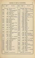
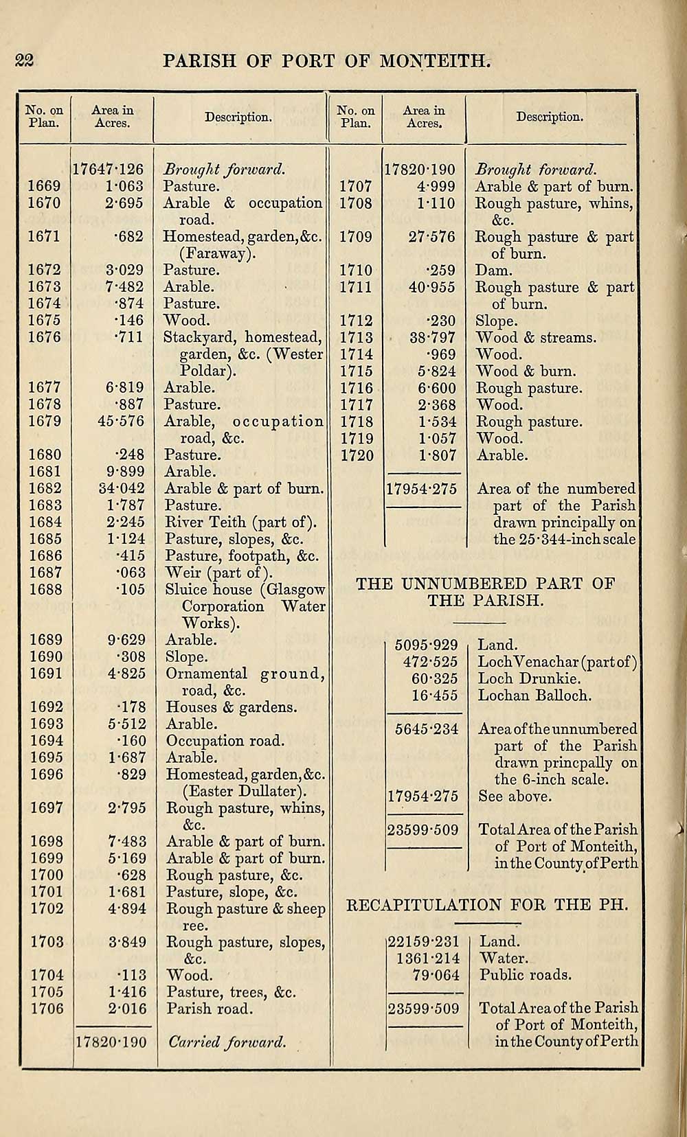
PARISH OF PORT OF MONTEITH
No. on
Plan.
Area in
Acres.
Description.
No. on
Plan.
Area in
Acres.
1669
1670
1671
1672
1673
1674
1675
1676
1677
1678
1679
1680
1681
1682
1683
1684
1685
1686
1687
1688
1689
1690
1691
1692
1693
1694
1695
1696
1697
1698
1699
1700
1701
1702
1703
1704
1705
1706
17647-126
1- 063
2- 695
•682
3- 029
7-482
•874
•146
•711
6-819
•887
45-576
•248
9-899
34-042
1- 787
2- 245
1-124
•415
•063
T05
9-629
•308
4- 825
•178
5- 512
•160
1- 687
•829
2- 795
7-483
5-169
•628
1-681
4-894
3- 849
•113
1- 416
2- 016
47820-190
Brought forward.
Pasture.
Arable & occupation
road.
Homestead, garden,&c.
(Faraway).
Pasture.
Arable.
Pasture.
Wood.
Stackyard, homestead,
garden, &c. (Wester
Poldar).
Arable.
Pasture.
Arable, occupation
road, &c.
Pasture.
Arable.
Arable & part of burn.
Pasture.
River Teith (part of).
Pasture, slopes, &c.
Pasture, footpath, &c.
Weir (part of).
Sluice house (Glasgow
Corporation Water
Works).
Arable.
Slope.
Ornamental ground,
road, &c.
Houses & gardens.
Arable.
Occupation road.
Arable.
Homestead, garden, &c.
(Easter Dullater).
Rough pasture, whins,
&c.
Arable & part of burn.
Arable & part of burn.
Rough pasture, &c.
Pasture, slope, &c.
Rough pasture & sheep
ree.
Rough pasture, slopes,
&c.
Wood.
Pasture, trees, &c.
Parish road.
Carried forward.
1707
1708
1709
1710
1711
1712
1713
1714
1715
1716
1717
1718
1719
1720
17820-190
4-999
1-110
27-576
•259
40-955
•230
38-797
•969
■824
•600
•368
•534
•057
•807
17954-275
Description.
Brought forward.
Arable & part of burn.
Rough pasture, whins,
&c.
Rough pasture & part
of burn.
Dam.
Rough pasture & part
of burn.
Slope.
Wood & streams.
Wood.
Wood & burn.
Rough pasture.
Wood.
Rough pasture.
Wood.
Arable.
Area of the numbered
part of the Parish
drawn principally on
the 25-344-inch scale
THE UNNUMBERED PART OF
THE PARISH.
5095-929
472-525
60-325
16-455
Land.
Loch V enachar (part of)
Loch Drunkie.
Lochan Balloch.
Area of the unnumbered
part of the Parish
drawn princpally on
the 6-inch scale.
See above.
Total Area of the Parish
of Port of Monteith,
in the County of Perth
RECAPITULATION FOR THE PH.
5645-234
17954-275
23599-509
22159-231
1361-214
79-064
23599-509
Land.
Water.
Public roads.
Total Area of the Parish
of Port of Monteith,
in the County of Perth
Set display mode to:
![]() Universal Viewer |
Universal Viewer | ![]() Mirador |
Large image | Transcription
Mirador |
Large image | Transcription
Images and transcriptions on this page, including medium image downloads, may be used under the Creative Commons Attribution 4.0 International Licence unless otherwise stated. ![]()
| Ordnance Survey Books of Reference 1855-1882 > Nairn -- Rathen > (632) Page 22 |
|---|
| Permanent URL | https://digital.nls.uk/99342403 |
|---|
| Attribution and copyright: |
|
|---|---|
| Description | These volumes record acreages of fields and land-use information for each parish in Scotland from 1855-1882. They were compiled with the Ordnance Survey 25 inch to the mile maps for that period, which cover all the inhabited parts of Scotland. Numbered land parcels on these maps, listed consecutively within each parish, are included in the relevant parish Book of Reference. |
|---|---|
| Shelfmark | Map.Ref.C18 |
| Additional NLS resources: | |