Melrose -- Muthill
(668) Page 6
Download files
Complete book:
Individual page:
Thumbnail gallery: Grid view | List view
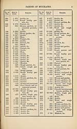
6
PARISH OF MUCKAIRtf.
No. on
Plan.
Area in
Acres.
Remarks.
No. on
Plan.
Area in
Acres.
Remarks.
376
377
378
379
380
381
382
383
384
385
2*509
6-697
•115
•830
1*821
9*732
10-581
2*277
5*419
4*471
Arable.
Rough heathy pas¬
ture, &e.
House and garden.
Arable.
Houses, rough pas¬
ture, gardens, &c.
Arable, &c.
Rough heathy pas¬
ture, arable, &c.
Rough heathy pas¬
ture, &c.
Rough heathy pas¬
ture and arable.
Arable.
386
387
388
389
390
391
392
393
394
725*884
11*306
9*451
3*654
22*177
2*586
25*250
4*504
•393
5872*557
Rough heathy pas¬
ture, &c.
Rough heathy pas¬
ture, &c.
Arable.
Pasture.
Pasture.
Rough pasture, &c.
Arable, &c.
River Nant (part of).
Houses, gardens, &c.
RECAPITULATION.
5625*367
23*838
105*311
•965
114*913
2*163
5872*557
Land.
Roads.
Foreshore.
Foreshore of tidal water.
Water.
Tidal water.
Area of the numbered part of the Parish.
Unnumbered.
15093*922
7*100
7*660
33*800
10*180
15152*662
5872*557
21025*219
Moorland, &c.
Lochan nam Breac Reamhra (part of),
Loch at Parish boundary (part of).
Loch Nant (part of).
Loch Lagain.
Lochan na Craige Deirge.
Loch on Parish boundary (part of).
Loch S.W. of Beinn Ghlas.
Loch N.W. of Carn Gaibhre.
Loch Bealach an Fhiodhain.
Lochan Craige Ruaidhe.
Area unnumbered.
Area numbered.
Area of the whole Parish.
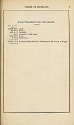
Set display mode to:
![]() Universal Viewer |
Universal Viewer | ![]() Mirador |
Large image | Transcription
Mirador |
Large image | Transcription
Images and transcriptions on this page, including medium image downloads, may be used under the Creative Commons Attribution 4.0 International Licence unless otherwise stated. ![]()
| Ordnance Survey Books of Reference 1855-1882 > Melrose -- Muthill > (668) Page 6 |
|---|
| Permanent URL | https://digital.nls.uk/99333999 |
|---|
| Attribution and copyright: |
|
|---|---|
| Description | These volumes record acreages of fields and land-use information for each parish in Scotland from 1855-1882. They were compiled with the Ordnance Survey 25 inch to the mile maps for that period, which cover all the inhabited parts of Scotland. Numbered land parcels on these maps, listed consecutively within each parish, are included in the relevant parish Book of Reference. |
|---|---|
| Shelfmark | Map.Ref.C18 |
| Additional NLS resources: | |