Melrose -- Muthill
(413) Page 87
Download files
Complete book:
Individual page:
Thumbnail gallery: Grid view | List view
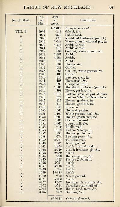
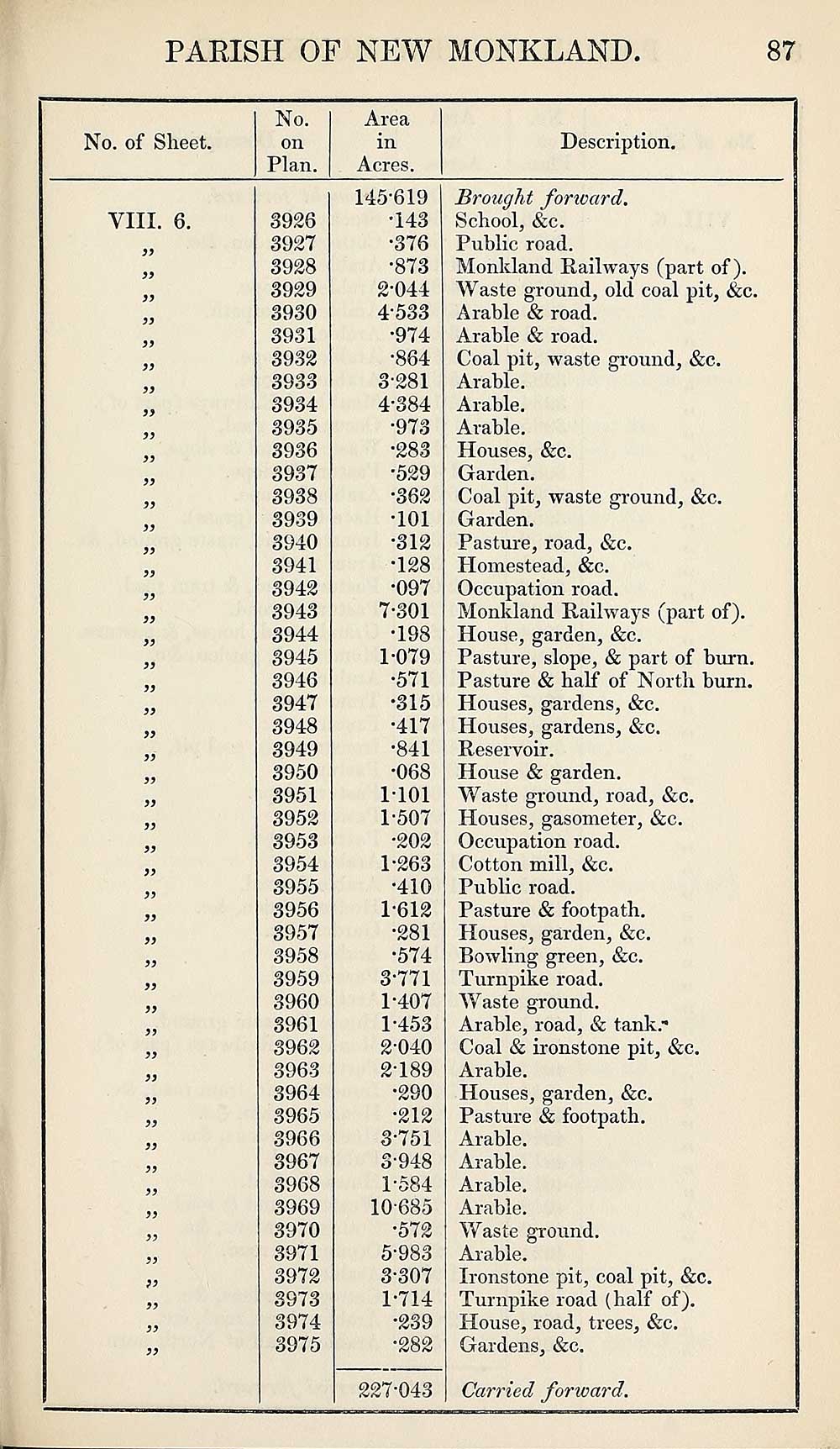
PARISH OF NEW MONKLAND
87
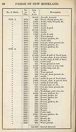
No. of Sheet.
No.
on
Plan.
Area
in
Acres.
Description.
VIII. 6.
a
>>
a
yf
a
a
))
a
a
a
a
a
a
a
a
a
a
a
a
a
a
a
a
a
a
a
a
a
a
a
a
a
a
a
a
a
a
a
a
a
a
a
if
a
if
if
8926
8927
8928
8929
8980
8981
8982
8988
8984
8985
8986
8987
8988
8989
8940
8941
8942
8948
8944
8945
8946
8947
8948
8949
8950
8951
8952
8958
8954
8955
8956
8957
8958
8959
8960
8961
8962
8968
8964
8965
8966
8967
8968
8969
8970
8971
8972
8978
8974
8975
145-619
•148
•876
•878
2- 044
4588
•974
•864
8-281
4- 884
•978
•288
•529
•862
•101
•812
•128
•097
7-801
•198
1-079
•571
•815
•417
•841
•068
1-101
1-507
•202
1-263
•410
1-612
•281
•574
3- 771
1-407
1- 453
2- 040
2189
•290
•212
3- 751
3-948
1-584
10-685
•572
5- 983
3-307
1-714
•239
•282
227-043
Brought fonvard.
School, &c.
Public road.
Monkland Railways (part of).
Waste ground, old coal pit, &c.
Arable & road.
Arable & road.
Coal pit, waste ground, &c.
Arable.
Arable.
Arable.
Houses, &c.
Garden.
Coal pit, waste ground, &c.
Garden.
Pasture, road, &c.
Plomestead, &c.
Occupation road.
Monkland Railways (part of).
House, garden, &c.
Pasture, slope, & part of burn.
Pasture & half of North burn.
Houses, gardens, &c.
Houses, gardens, &c.
Reservoir.
House & garden.
Waste ground, road, &c.
Houses, gasometer, &c.
Occupation road.
Cotton mill, &c.
Public road.
Pasture & footpath.
Houses, garden, &c.
Bowling green, &c.
Turnpike road.
Waste ground.
Arable, road, & tank.-
Coal & ironstone pit, &c.
Arable.
Houses, garden, &c.
Pasture & footpath.
Arable.
Arable.
Arable.
Arable.
Waste ground.
Arable.
Ironstone pit, coal pit, &c.
Turnpike road (half of).
House, road, trees, &c.
Gardens, &c.
Carried forward.
87
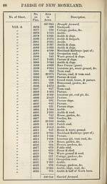
No. of Sheet.
No.
on
Plan.
Area
in
Acres.
Description.
VIII. 6.
a
>>
a
yf
a
a
))
a
a
a
a
a
a
a
a
a
a
a
a
a
a
a
a
a
a
a
a
a
a
a
a
a
a
a
a
a
a
a
a
a
a
a
if
a
if
if
8926
8927
8928
8929
8980
8981
8982
8988
8984
8985
8986
8987
8988
8989
8940
8941
8942
8948
8944
8945
8946
8947
8948
8949
8950
8951
8952
8958
8954
8955
8956
8957
8958
8959
8960
8961
8962
8968
8964
8965
8966
8967
8968
8969
8970
8971
8972
8978
8974
8975
145-619
•148
•876
•878
2- 044
4588
•974
•864
8-281
4- 884
•978
•288
•529
•862
•101
•812
•128
•097
7-801
•198
1-079
•571
•815
•417
•841
•068
1-101
1-507
•202
1-263
•410
1-612
•281
•574
3- 771
1-407
1- 453
2- 040
2189
•290
•212
3- 751
3-948
1-584
10-685
•572
5- 983
3-307
1-714
•239
•282
227-043
Brought fonvard.
School, &c.
Public road.
Monkland Railways (part of).
Waste ground, old coal pit, &c.
Arable & road.
Arable & road.
Coal pit, waste ground, &c.
Arable.
Arable.
Arable.
Houses, &c.
Garden.
Coal pit, waste ground, &c.
Garden.
Pasture, road, &c.
Plomestead, &c.
Occupation road.
Monkland Railways (part of).
House, garden, &c.
Pasture, slope, & part of burn.
Pasture & half of North burn.
Houses, gardens, &c.
Houses, gardens, &c.
Reservoir.
House & garden.
Waste ground, road, &c.
Houses, gasometer, &c.
Occupation road.
Cotton mill, &c.
Public road.
Pasture & footpath.
Houses, garden, &c.
Bowling green, &c.
Turnpike road.
Waste ground.
Arable, road, & tank.-
Coal & ironstone pit, &c.
Arable.
Houses, garden, &c.
Pasture & footpath.
Arable.
Arable.
Arable.
Arable.
Waste ground.
Arable.
Ironstone pit, coal pit, &c.
Turnpike road (half of).
House, road, trees, &c.
Gardens, &c.
Carried forward.
Set display mode to:
![]() Universal Viewer |
Universal Viewer | ![]() Mirador |
Large image | Transcription
Mirador |
Large image | Transcription
Images and transcriptions on this page, including medium image downloads, may be used under the Creative Commons Attribution 4.0 International Licence unless otherwise stated. ![]()
| Ordnance Survey Books of Reference 1855-1882 > Melrose -- Muthill > (413) Page 87 |
|---|
| Permanent URL | https://digital.nls.uk/99331155 |
|---|
| Attribution and copyright: |
|
|---|---|
| Description | These volumes record acreages of fields and land-use information for each parish in Scotland from 1855-1882. They were compiled with the Ordnance Survey 25 inch to the mile maps for that period, which cover all the inhabited parts of Scotland. Numbered land parcels on these maps, listed consecutively within each parish, are included in the relevant parish Book of Reference. |
|---|---|
| Shelfmark | Map.Ref.C18 |
| Additional NLS resources: | |