Melrose -- Muthill
(76) Page 66
Download files
Complete book:
Individual page:
Thumbnail gallery: Grid view | List view
68
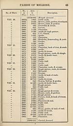
PARISH OF MELROSE
No. of Sheet.
No.
on
Plan.
Area
in
Acres.
Description.
VIII. 10.
>y
y>
ft
tt
ft
tf
tt
tt
a
tt
tt
it
a
it
a
it
a
VIII. 14.
a
it
it
tt
it
tt
a
tt
2905
2906
2907
2908
2909
2910
2911
2912
2913
2914
2915
2916
2917
2918
2919
2920
2921
2922
2923
2924
2925
2926
2927
2928
2929
2929a
2930
2931
25989*251
•109
•558
1- 980
2- 939
1-785
1-696
•153
4- 646
9-738
1-723
12-187
5- 697
•598
3- 473
•233
•588
•640
11-934
■044
•233
4*126
•218
1-384
•765
1-383
•007
•119
•079
26058-286
Brought forward.
House & garden.
Private road.
Arable.
Arable.
Rough pasture, road, & streams.
Plantation & road.
Pasture.
Arable.
Arable.
Plantation & double fence.
Arable.
Arable.
Plantation, road, & stream.
Arable.
Mill-pond.
Whitehill, farmsteading & yards.
Whitehill, house, garden, &c.
Pasture.
Space between boundary & fence.
Private road.
Arable.
Plantation.
Whitelee, farmsteading, yards, &c.
Arable.
Plantation, small pond, &c.
Space between boundary & fence.
Space between boundary & fence.
Plantation.
RECAPITULATION.
25354-649
324-696
264-566
114-375
26058-286
Land.
Public roads.
Water.
Railways.
Total area of the Parish of Melrose,
in the County of Roxburgh.
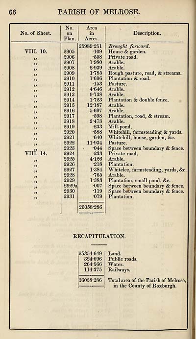
Set display mode to:
![]() Universal Viewer |
Universal Viewer | ![]() Mirador |
Large image | Transcription
Mirador |
Large image | Transcription
Images and transcriptions on this page, including medium image downloads, may be used under the Creative Commons Attribution 4.0 International Licence unless otherwise stated. ![]()
| Ordnance Survey Books of Reference 1855-1882 > Melrose -- Muthill > (76) Page 66 |
|---|
| Permanent URL | https://digital.nls.uk/99327327 |
|---|
| Attribution and copyright: |
|
|---|---|
| Description | These volumes record acreages of fields and land-use information for each parish in Scotland from 1855-1882. They were compiled with the Ordnance Survey 25 inch to the mile maps for that period, which cover all the inhabited parts of Scotland. Numbered land parcels on these maps, listed consecutively within each parish, are included in the relevant parish Book of Reference. |
|---|---|
| Shelfmark | Map.Ref.C18 |
| Additional NLS resources: | |