Kilmartin -- Kinclaven
(423) Page 19
Download files
Complete book:
Individual page:
Thumbnail gallery: Grid view | List view

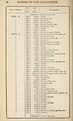
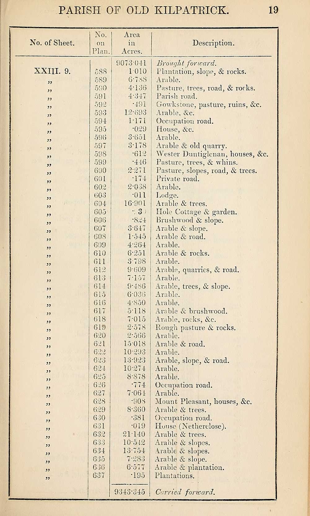
PARISH OF OLD KILPATRICK;.
19
No. of Sheet.
No.
on
Plan.
Area
in
Acres.
Description.
XXIII. 9.
)}
jy
yy
yy
yy
yy
yy
yy
yy
yy
yy
yy
yy
yy
yy
yy
588
589
590
591
592
593
594
595
590
597
598
599
690
601
602
603
604
605
606
607
608
609
610
611
612
613
614
615
616
617
618
619
620
621
622
623
624
625
626
627
628
629
630
631
632
633
634
635
636
637
9073 041
1 010
6'7SS
4-136
4-347
•491
12- 693
M71
•029
3-651
3-178
•612
•416
2-271
•174
2- 038
•Oil
16-901
•: 3;
*824
3- 647
1-545
4- 264
6- 251
3- 798
9-609
7- 157
9-486
6036
4- 850
5- 118
7- 015
2’57 8
2*566
15018
10-293
13- 923
10-274
8- 878
•774
7- 061
•908
8- 360
•381
•019
21140
10-512
13-754
7-283
6"577
*195
9343-345
Brought forward.
Plantation, slope, & rocks.
Arable.
Pasture, trees, road, & rocks.
Parish road.
Gowkstoue, pasture, ruins, See.
Arable, Sec.
Occupation road.
House, Sec.
Arable.
Arable & old quarry.
Wester Duntig-lenan, bouses, Sec.
Pasture, trees, & whins.
Pasture, slopes, road, & trees.
Private road.
Arable.
Lods'e.
O
Arable & trees.
Hole Cottage & garden.
Brushwood Se slope.
Arable Se slope.
Arable & road.
Arable.
Arable & rocks.
Arable.
Arable, quarries, & road.
Arable.
Arable, trees, & slope.
Arable.
Arable.
Arable & brushwood.
Arable, rocks, Sec.
Rough pasture & rocks.
Arable.
Arable & road.
Arable.
Arable, slope, & road.
Arable.
Arable.
Occupation road.
Arable.
Mount Pleasant, bouses, &C.
Arable Sz trees.
Occupation road.
House (Netherelose).
Arable & trees.
Arable & slopes.
Arable; & slopes.
Arable & slope.
Arable & plantation.
Plantations.
Carried forward,.
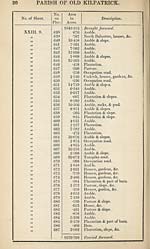
Set display mode to:
![]() Universal Viewer |
Universal Viewer | ![]() Mirador |
Large image | Transcription
Mirador |
Large image | Transcription
Images and transcriptions on this page, including medium image downloads, may be used under the Creative Commons Attribution 4.0 International Licence unless otherwise stated. ![]()
| Ordnance Survey Books of Reference 1855-1882 > Kilmartin -- Kinclaven > (423) Page 19 |
|---|
| Permanent URL | https://digital.nls.uk/99300731 |
|---|
| Attribution and copyright: |
|
|---|---|
| Description | These volumes record acreages of fields and land-use information for each parish in Scotland from 1855-1882. They were compiled with the Ordnance Survey 25 inch to the mile maps for that period, which cover all the inhabited parts of Scotland. Numbered land parcels on these maps, listed consecutively within each parish, are included in the relevant parish Book of Reference. |
|---|---|
| Shelfmark | Map.Ref.C18 |
| Additional NLS resources: | |