Keig -- Kilmaronock
(563) Page 11
Thumbnail gallery: Grid view | List view
PARISH OF KILLIN,
II
No. on
Plan.
Area in
Acres.
Remarks.
No. on
Plan.
Area in
Acres.
Remarks.
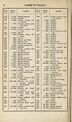
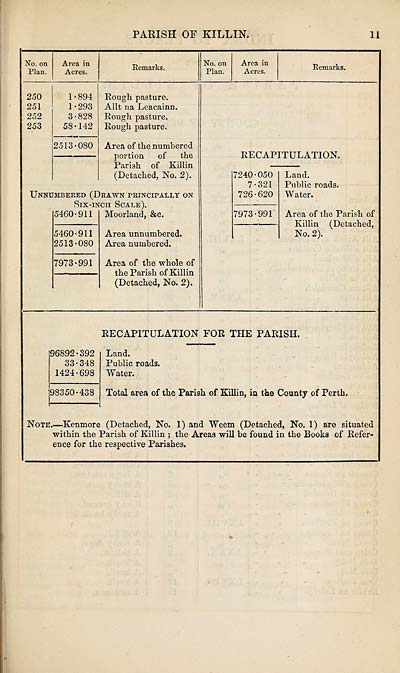
250
251
252
253
1-894
1-293
3-828
58-142
2513-080
Rough pasture.
Allt na Leacainn.
Rough pasture.
Rough pasture.
Area of the numbered
portion of the
Parish of Killin
(Detached, No. 2).
Unnumbered (Drawn principally on
Six-inch Scale).
5460-911 Moorland, &c.
5460-911
2513-080
7973-991
Area unnumbered.
Area numbered.
Area of the whole of
the Parish of Killin
(Detached, No. 2).
RECAPITULATION.
7240-050
7-321
726-620
7973-991
Land.
Public roads.
W ater.
Area of the Parish of
Killin (Detached,
No. 2).
RECAPITULATION FOR THE PARISH.
96892-392
33-348
1424-698
98350-438
Land.
Public roads.
Water.
Total area of the Parish of Killin, in the County of Perth.
Note.—Kenmore (Detached, No. 1) and Weem (Detached, No. 1) are situated
within the Parish of Killin ; the Areas will be found in the Books of Refer¬
ence for the respective Parishes,
II
No. on
Plan.
Area in
Acres.
Remarks.
No. on
Plan.
Area in
Acres.
Remarks.
250
251
252
253
1-894
1-293
3-828
58-142
2513-080
Rough pasture.
Allt na Leacainn.
Rough pasture.
Rough pasture.
Area of the numbered
portion of the
Parish of Killin
(Detached, No. 2).
Unnumbered (Drawn principally on
Six-inch Scale).
5460-911 Moorland, &c.
5460-911
2513-080
7973-991
Area unnumbered.
Area numbered.
Area of the whole of
the Parish of Killin
(Detached, No. 2).
RECAPITULATION.
7240-050
7-321
726-620
7973-991
Land.
Public roads.
W ater.
Area of the Parish of
Killin (Detached,
No. 2).
RECAPITULATION FOR THE PARISH.
96892-392
33-348
1424-698
98350-438
Land.
Public roads.
Water.
Total area of the Parish of Killin, in the County of Perth.
Note.—Kenmore (Detached, No. 1) and Weem (Detached, No. 1) are situated
within the Parish of Killin ; the Areas will be found in the Books of Refer¬
ence for the respective Parishes,
Set display mode to:
![]() Universal Viewer |
Universal Viewer | ![]() Mirador |
Large image | Transcription
Mirador |
Large image | Transcription
Images and transcriptions on this page, including medium image downloads, may be used under the Creative Commons Attribution 4.0 International Licence unless otherwise stated. ![]()
| Ordnance Survey Books of Reference 1855-1882 > Keig -- Kilmaronock > (563) Page 11 |
|---|
| Permanent URL | https://digital.nls.uk/99294583 |
|---|
| Attribution and copyright: |
|
|---|---|
| Description | These volumes record acreages of fields and land-use information for each parish in Scotland from 1855-1882. They were compiled with the Ordnance Survey 25 inch to the mile maps for that period, which cover all the inhabited parts of Scotland. Numbered land parcels on these maps, listed consecutively within each parish, are included in the relevant parish Book of Reference. |
|---|---|
| Shelfmark | Map.Ref.C18 |
| Additional NLS resources: | |