Keig -- Kilmaronock
(414) Page 10
Download files
Complete book:
Individual page:
Thumbnail gallery: Grid view | List view
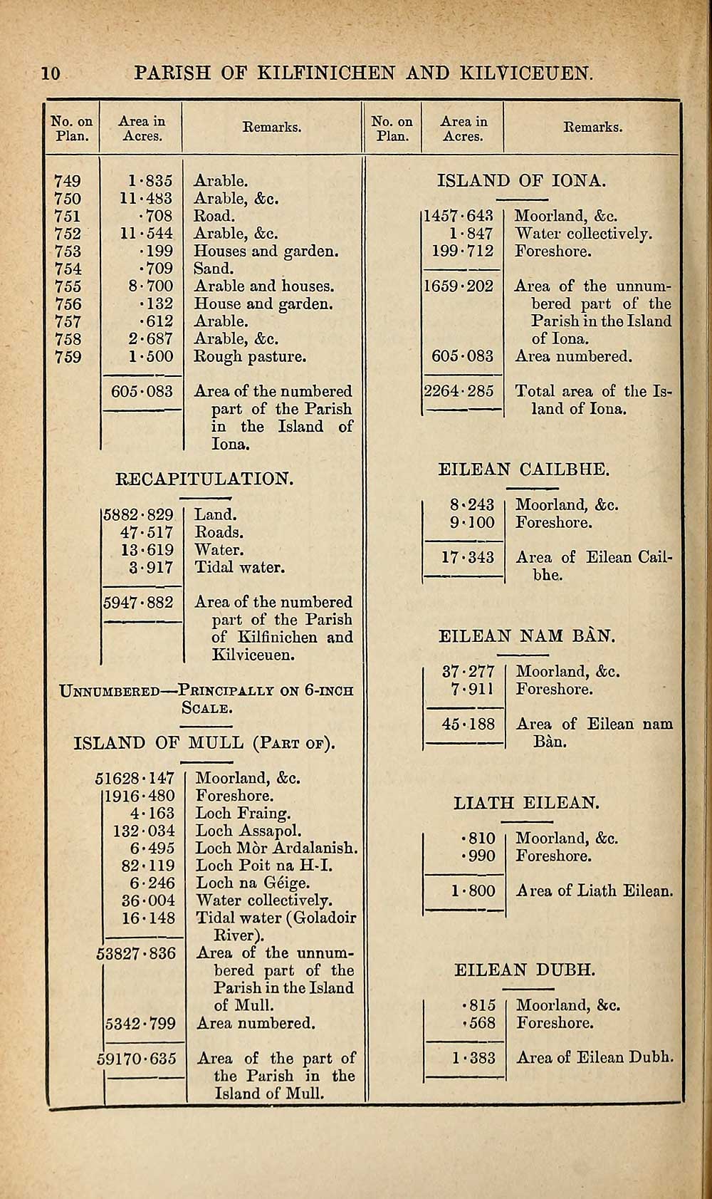
10
PARISH OF KILFINICHEN AND KILVICEUEN.
No. on
Plan.
Area in
Acres.
Remarks.
No. on
Plan.
Area in
Acres.
Remarks.
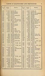
749
750
751
752
753
754
755
756
757
758
759
1- 835
11-483
•708
11-544
•199
•709
8-700
•132
•612
2- 687
1-500
605-083
Arable.
Arable, &c.
Road.
Arable, &c.
Houses and garden.
Sand.
Arable and houses.
House and garden.
Arable.
Arable, &c.
Rough pasture.
Area of the numbered
part of the Parish
in the Island of
Iona.
RECAPITULATION.
5882-829
47-517
13-619
3-917
Land.
Roads.
Water.
Tidal water.
Area of the numbered
part of the Parish
of Kilfinichen and
Kilviceuen.
Unnumbered—Principally on 6-inch
Scale.
5947-882
ISLAND OF MULL (Part of).
51628-147
1916-480
4-163
132-034
6-495
82-119
6-246
36-004
16-148
53827-836
5342-799
59170-635
Moorland, &c.
Foreshore.
Loch Fraing.
Loch Assapol.
Loch Mor Ardalanish.
Loch Poit na H-I.
Loch na Geige.
Water collectively.
Tidal water (Goladoir
River).
Area of the unnum¬
bered part of the
Parish in the Island
of Mull.
Area numbered.
Area of the part of
the Parish in the
Island of Mull.
ISLAND OF IONA.
1457-643
1-847
199-712
1659-202
605-083
2264-285
Moorland, &c.
Water collectively.
Foreshore.
Area of the unnum¬
bered part of the
Parish in the Island
of Iona.
Area numbered.
Total area of the Is¬
land of Iona.
FILE AN CAILBHE.
8- 243
9- 100
17-343
Moorland, &c.
Foreshore.
Area of Eilean Cail-
bhe.
EILEAN NAM BAN.
37-277
7-911
45-188
Moorland, &c.
Foreshore.
Area of Eilean nam
Ban.
LIATH EILEAN.
810
990
1-800
Moorland, &c.
Foreshore.
A rea of Liath Eilean.
EILEAN DUBH.
815
■568
1-383
Moorland, &c.
Foreshore.
Area of Eilean Dubh.
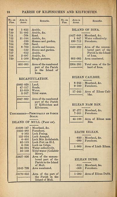
PARISH OF KILFINICHEN AND KILVICEUEN.
No. on
Plan.
Area in
Acres.
Remarks.
No. on
Plan.
Area in
Acres.
Remarks.
749
750
751
752
753
754
755
756
757
758
759
1- 835
11-483
•708
11-544
•199
•709
8-700
•132
•612
2- 687
1-500
605-083
Arable.
Arable, &c.
Road.
Arable, &c.
Houses and garden.
Sand.
Arable and houses.
House and garden.
Arable.
Arable, &c.
Rough pasture.
Area of the numbered
part of the Parish
in the Island of
Iona.
RECAPITULATION.
5882-829
47-517
13-619
3-917
Land.
Roads.
Water.
Tidal water.
Area of the numbered
part of the Parish
of Kilfinichen and
Kilviceuen.
Unnumbered—Principally on 6-inch
Scale.
5947-882
ISLAND OF MULL (Part of).
51628-147
1916-480
4-163
132-034
6-495
82-119
6-246
36-004
16-148
53827-836
5342-799
59170-635
Moorland, &c.
Foreshore.
Loch Fraing.
Loch Assapol.
Loch Mor Ardalanish.
Loch Poit na H-I.
Loch na Geige.
Water collectively.
Tidal water (Goladoir
River).
Area of the unnum¬
bered part of the
Parish in the Island
of Mull.
Area numbered.
Area of the part of
the Parish in the
Island of Mull.
ISLAND OF IONA.
1457-643
1-847
199-712
1659-202
605-083
2264-285
Moorland, &c.
Water collectively.
Foreshore.
Area of the unnum¬
bered part of the
Parish in the Island
of Iona.
Area numbered.
Total area of the Is¬
land of Iona.
FILE AN CAILBHE.
8- 243
9- 100
17-343
Moorland, &c.
Foreshore.
Area of Eilean Cail-
bhe.
EILEAN NAM BAN.
37-277
7-911
45-188
Moorland, &c.
Foreshore.
Area of Eilean nam
Ban.
LIATH EILEAN.
810
990
1-800
Moorland, &c.
Foreshore.
A rea of Liath Eilean.
EILEAN DUBH.
815
■568
1-383
Moorland, &c.
Foreshore.
Area of Eilean Dubh.
Set display mode to:
![]() Universal Viewer |
Universal Viewer | ![]() Mirador |
Large image | Transcription
Mirador |
Large image | Transcription
Images and transcriptions on this page, including medium image downloads, may be used under the Creative Commons Attribution 4.0 International Licence unless otherwise stated. ![]()
| Ordnance Survey Books of Reference 1855-1882 > Keig -- Kilmaronock > (414) Page 10 |
|---|
| Permanent URL | https://digital.nls.uk/99292939 |
|---|
| Attribution and copyright: |
|
|---|---|
| Description | These volumes record acreages of fields and land-use information for each parish in Scotland from 1855-1882. They were compiled with the Ordnance Survey 25 inch to the mile maps for that period, which cover all the inhabited parts of Scotland. Numbered land parcels on these maps, listed consecutively within each parish, are included in the relevant parish Book of Reference. |
|---|---|
| Shelfmark | Map.Ref.C18 |
| Additional NLS resources: | |