Keig -- Kilmaronock
(320) Page 18
Download files
Complete book:
Individual page:
Thumbnail gallery: Grid view | List view
18
PARISH OF KILDALTON AND OA.
No. on
Plan.
Area in
Acres.
Remarks.
No. on
Plan.
Area in
Acres.
Remarks.
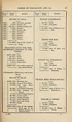
OUTRAM.
4*172
10*436
14*608
Land.
Foreshore.
Area of the Island of
Outram,
EILEAN BHRlDE.
20-827
6-540
27*367
Land.
Foreshore.
Area of Eilean Bhride.
CEANN NAN SGEIREIN.
9-479
5-261
14-740
Land.
Foreshore.
Area of Ceann nan
Sgeirein.
EILEAN NAN CAORACH.
3*386
2-415
5*801
Land.
Foreshore.
Area of Eilean nan
Caorach.
CAM SGEIR.
1-097
1-884
2*981
Land.
Foreshore.
Area of Cam Sgeir.
TARR SGEIR.
1SEANACH M5R.
1-300
•238
1-538
Land.
Foreshore.
Area of the Island of
Iseanach Mor.
CORR SGEIR.
1*721
•361
2*082
Land.
Foreshore.
Area of the Island of
Corr Sgeir.
■989
030
1-019
Land.
Foreshore.
Area of Tarr Sgeir.
ABSTRACT OF THE PARISH.
23682*001
24698*288
48380-289
Area of the unnum¬
bered part of the
Parish.
Area of the numbered
part of the Parish.
Total area of the
Parish of Kildalton
and Oa.
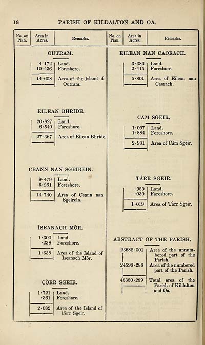
PARISH OF KILDALTON AND OA.
No. on
Plan.
Area in
Acres.
Remarks.
No. on
Plan.
Area in
Acres.
Remarks.
OUTRAM.
4*172
10*436
14*608
Land.
Foreshore.
Area of the Island of
Outram,
EILEAN BHRlDE.
20-827
6-540
27*367
Land.
Foreshore.
Area of Eilean Bhride.
CEANN NAN SGEIREIN.
9-479
5-261
14-740
Land.
Foreshore.
Area of Ceann nan
Sgeirein.
EILEAN NAN CAORACH.
3*386
2-415
5*801
Land.
Foreshore.
Area of Eilean nan
Caorach.
CAM SGEIR.
1-097
1-884
2*981
Land.
Foreshore.
Area of Cam Sgeir.
TARR SGEIR.
1SEANACH M5R.
1-300
•238
1-538
Land.
Foreshore.
Area of the Island of
Iseanach Mor.
CORR SGEIR.
1*721
•361
2*082
Land.
Foreshore.
Area of the Island of
Corr Sgeir.
■989
030
1-019
Land.
Foreshore.
Area of Tarr Sgeir.
ABSTRACT OF THE PARISH.
23682*001
24698*288
48380-289
Area of the unnum¬
bered part of the
Parish.
Area of the numbered
part of the Parish.
Total area of the
Parish of Kildalton
and Oa.
Set display mode to:
![]() Universal Viewer |
Universal Viewer | ![]() Mirador |
Large image | Transcription
Mirador |
Large image | Transcription
Images and transcriptions on this page, including medium image downloads, may be used under the Creative Commons Attribution 4.0 International Licence unless otherwise stated. ![]()
| Ordnance Survey Books of Reference 1855-1882 > Keig -- Kilmaronock > (320) Page 18 |
|---|
| Permanent URL | https://digital.nls.uk/99291907 |
|---|
| Attribution and copyright: |
|
|---|---|
| Description | These volumes record acreages of fields and land-use information for each parish in Scotland from 1855-1882. They were compiled with the Ordnance Survey 25 inch to the mile maps for that period, which cover all the inhabited parts of Scotland. Numbered land parcels on these maps, listed consecutively within each parish, are included in the relevant parish Book of Reference. |
|---|---|
| Shelfmark | Map.Ref.C18 |
| Additional NLS resources: | |