Glenisla -- Jura
(269) Page 11
Download files
Complete book:
Individual page:
Thumbnail gallery: Grid view | List view
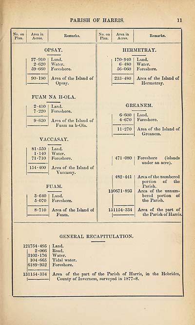
PARISH OF HARRIS.
11
No. on
Plan.
Area in
Acres.
Remarks.
No. on
Plan.
Area in
Acres.
Remarks.
OPSAY.
27-910
2-620
59-660
90-190
Land.
Water.
Foreshore.
Area of the Island of
Op say.
FUAM NA H-OLA.
2-410
7-220
9-630
Land.
Foreshore.
Area of the Island of
Fuara na h-Ola.
YACCASAY.
81-550
1-140
71-710
154-400
Land.
Water.
Foreshore.
Area of the Island of
Yaccasay.
FUAM.
3-640
5-070
8-710
Land.
Foreshore.
Area of the Island of
Fuam.
HERMETRAY.
170-940
6-480
56-060
233-480
Land.
Water.
Foreshore.
Area of the Island of
Hermetray.
GREANEM.
6-600
4-670
11-270
471-080
482-441
130671-893
131154-334
Land.
Foreshore.
Area of the Island of
Greanem.
Foreshore (islands
under an acre).
Area of the numbered
portion of the
Parish.
Area of the unnum¬
bered portion of
the Parish.
Area of the part of
the Parish of Harris
GENERAL RECAPITULATION.
121754-495
2-066
3103-176
104-665
6189-932
131154-334
Land.
Road.
Water.
Tidal water.
Foreshore.
Area of the part of the Parish of Harris, in the Hebrides,
County of Inverness, surveyed in 1877-8.
Set display mode to:
![]() Universal Viewer |
Universal Viewer | ![]() Mirador |
Large image | Transcription
Mirador |
Large image | Transcription
Images and transcriptions on this page, including medium image downloads, may be used under the Creative Commons Attribution 4.0 International Licence unless otherwise stated. ![]()
| Ordnance Survey Books of Reference 1855-1882 > Glenisla -- Jura > (269) Page 11 |
|---|
| Permanent URL | https://digital.nls.uk/99283347 |
|---|
| Attribution and copyright: |
|
|---|---|
| Description | These volumes record acreages of fields and land-use information for each parish in Scotland from 1855-1882. They were compiled with the Ordnance Survey 25 inch to the mile maps for that period, which cover all the inhabited parts of Scotland. Numbered land parcels on these maps, listed consecutively within each parish, are included in the relevant parish Book of Reference. |
|---|---|
| Shelfmark | Map.Ref.C18 |
| Additional NLS resources: | |