Glenisla -- Jura
(266) Page 8
Download files
Complete book:
Individual page:
Thumbnail gallery: Grid view | List view
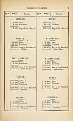
8
PARISH OF HARRIS.
No. on
Plan.
Area in
Acres.
Remarks.
No. on
Plan.
Area in
Acres.
Remarks.
ISLAND WITHOUT NAME, SITU¬
ATED IN “THE OBE.”
2-100
2-400
4-500
Land.
Foreshore.
Area of the Island.
SUEM AN T-SRUITH.
2-220
3-300
5-520
Land.
Foreshore.
Area of the Island of
Suem an t-Sruith.
FIAR EILEAN.
6-720
13-060
19-780
Land.
Foreshore.
Area of Fiar Eilean.
LINGARABAY ISLAND.
35-290
8-850
44-140
Land.
Foreshore.
Area of Lingarabay
Island.
FIN SB AY ISLAND.
3-170
5-110
8-280
Land.
Foreshore.
Area of Finsbay Is¬
land.
EILEAN QUIDNISH.
1-310
4-170
5-480
Land.
Foreshore.
Area of Eilean Quid-
nish.
MANISH ISLAND.
2-690
1-180
3-870
Land.
Foreshore.
Area of Manish Is¬
land.
EILEAN NAN EUN.
1-530
3-850
5-380
Land.
Foreshore.
Area of Eilean nan
Eun,
BERNERAY.
2431-409
62-426
4-120
637-684
3135-639
Moorland, &c.
Loch Bhruist.
Water,
Foreshore.
Area of the unnum¬
bered portion of the
Island of Beraeray.
TOROGAY.
51-970
35-550
87-520
Land.
Foreshore.
Area of the Island of
Torogay.
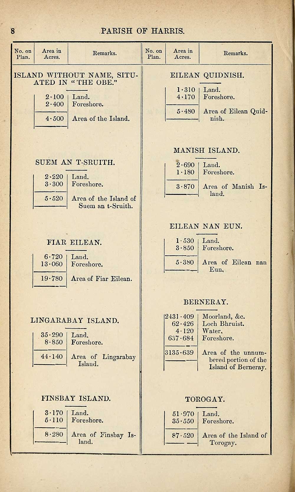
Set display mode to:
![]() Universal Viewer |
Universal Viewer | ![]() Mirador |
Large image | Transcription
Mirador |
Large image | Transcription
Images and transcriptions on this page, including medium image downloads, may be used under the Creative Commons Attribution 4.0 International Licence unless otherwise stated. ![]()
| Ordnance Survey Books of Reference 1855-1882 > Glenisla -- Jura > (266) Page 8 |
|---|
| Permanent URL | https://digital.nls.uk/99283311 |
|---|
| Attribution and copyright: |
|
|---|---|
| Description | These volumes record acreages of fields and land-use information for each parish in Scotland from 1855-1882. They were compiled with the Ordnance Survey 25 inch to the mile maps for that period, which cover all the inhabited parts of Scotland. Numbered land parcels on these maps, listed consecutively within each parish, are included in the relevant parish Book of Reference. |
|---|---|
| Shelfmark | Map.Ref.C18 |
| Additional NLS resources: | |