Forgandenny -- Glendevon
(491) Page 21
Thumbnail gallery: Grid view | List view
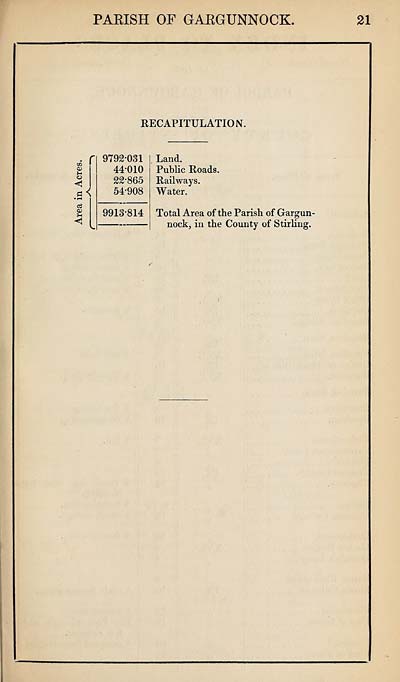
PARISH OF GARGUNNOCK.
KECAPITULATION.
tr>
a>
o
<1
• r—<
CS
(O
?H
<1
9792*031
44*010
22*865
54*908
9913*814
Land.
Public Roads.
Railways.
Water.
Total Area of the Parish of Gargun-
nock, in the County of Stirling.
21
KECAPITULATION.
tr>
a>
o
<1
• r—<
CS
(O
?H
<1
9792*031
44*010
22*865
54*908
9913*814
Land.
Public Roads.
Railways.
Water.
Total Area of the Parish of Gargun-
nock, in the County of Stirling.
21
Set display mode to:
![]() Universal Viewer |
Universal Viewer | ![]() Mirador |
Large image | Transcription
Mirador |
Large image | Transcription
Images and transcriptions on this page, including medium image downloads, may be used under the Creative Commons Attribution 4.0 International Licence unless otherwise stated. ![]()
| Ordnance Survey Books of Reference 1855-1882 > Forgandenny -- Glendevon > (491) Page 21 |
|---|
| Permanent URL | https://digital.nls.uk/99278279 |
|---|
| Attribution and copyright: |
|
|---|---|
| Description | These volumes record acreages of fields and land-use information for each parish in Scotland from 1855-1882. They were compiled with the Ordnance Survey 25 inch to the mile maps for that period, which cover all the inhabited parts of Scotland. Numbered land parcels on these maps, listed consecutively within each parish, are included in the relevant parish Book of Reference. |
|---|---|
| Shelfmark | Map.Ref.C18 |
| Additional NLS resources: | |