Eday -- Forfar
(694) Page 34
Download files
Complete book:
Individual page:
Thumbnail gallery: Grid view | List view
34
PARISH OF FORFAR.
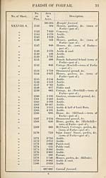
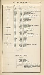
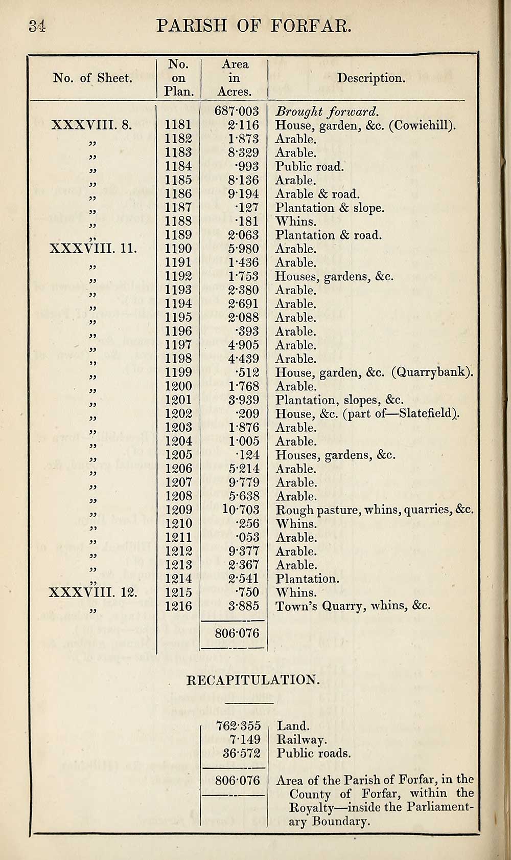
No. of Sheet.
No.
on
Plan.
Area
in
Acres.
Description.
XXXVIII. 8.
33
33
XXXVIII. 11.
XXXVIII. 12.
1181
1182
1183
1184
1185
1186
1187
1188
1189
1190
1191
1192
1193
1194
1195
1196
1197
1198
1199
1200
1201
1202
1203
1204
1205
1206
1207
1208
1209
1210
1211
1212
1213
1214
1215
1216
687*003
2-116
1- 873
8-329
•993
8- 136
9194
•127
•181
2- 063
5-980
1-436
1- 753
2- 380
2- 691
2-088
•393
4-905
4- 439
•512
1-768
3- 939
•209
1- 876
1005
•124
5- 214
9- 779
5-638
10-703
•256
•053
9-377
2- 367
2- 541
•750
3- 885
806-076
Brought forward.
House, garden, &c. (Cowiehill).
Arable.
Arable.
Public road.
Arable.
Arable & road.
Plantation & slope.
Whins.
Plantation & road.
Arable.
Arable.
Houses, gardens, &c.
Arable.
Arable.
Arable.
Arable.
Arable.
Arable.
House, garden, &c. (Quarrybank).
Arable.
Plantation, slopes, &c.
House, &c. (part of—Slatefield).
Arable.
Arable.
Houses, gardens, &c.
Arable.
Arable.
Arable.
Rough pasture, whins, quarries, &c.
Whins.
Arable.
Arable.
Arable.
Plantation.
Whins.
Town’s Quarry, whins, &c.
RECAPITULATION.
762-355
7-149
36-572
806-076
Land.
Railway.
Public roads.
Area of the Parish of Forfar, in the
County of Forfar, within the
Royalty—inside the Parliament¬
ary Boundary.
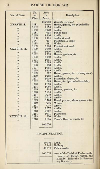
PARISH OF FORFAR.
No. of Sheet.
No.
on
Plan.
Area
in
Acres.
Description.
XXXVIII. 8.
33
33
XXXVIII. 11.
XXXVIII. 12.
1181
1182
1183
1184
1185
1186
1187
1188
1189
1190
1191
1192
1193
1194
1195
1196
1197
1198
1199
1200
1201
1202
1203
1204
1205
1206
1207
1208
1209
1210
1211
1212
1213
1214
1215
1216
687*003
2-116
1- 873
8-329
•993
8- 136
9194
•127
•181
2- 063
5-980
1-436
1- 753
2- 380
2- 691
2-088
•393
4-905
4- 439
•512
1-768
3- 939
•209
1- 876
1005
•124
5- 214
9- 779
5-638
10-703
•256
•053
9-377
2- 367
2- 541
•750
3- 885
806-076
Brought forward.
House, garden, &c. (Cowiehill).
Arable.
Arable.
Public road.
Arable.
Arable & road.
Plantation & slope.
Whins.
Plantation & road.
Arable.
Arable.
Houses, gardens, &c.
Arable.
Arable.
Arable.
Arable.
Arable.
Arable.
House, garden, &c. (Quarrybank).
Arable.
Plantation, slopes, &c.
House, &c. (part of—Slatefield).
Arable.
Arable.
Houses, gardens, &c.
Arable.
Arable.
Arable.
Rough pasture, whins, quarries, &c.
Whins.
Arable.
Arable.
Arable.
Plantation.
Whins.
Town’s Quarry, whins, &c.
RECAPITULATION.
762-355
7-149
36-572
806-076
Land.
Railway.
Public roads.
Area of the Parish of Forfar, in the
County of Forfar, within the
Royalty—inside the Parliament¬
ary Boundary.
Set display mode to:
![]() Universal Viewer |
Universal Viewer | ![]() Mirador |
Large image | Transcription
Mirador |
Large image | Transcription
Images and transcriptions on this page, including medium image downloads, may be used under the Creative Commons Attribution 4.0 International Licence unless otherwise stated. ![]()
| Ordnance Survey Books of Reference 1855-1882 > Eday -- Forfar > (694) Page 34 |
|---|
| Permanent URL | https://digital.nls.uk/99272527 |
|---|
| Attribution and copyright: |
|
|---|---|
| Description | These volumes record acreages of fields and land-use information for each parish in Scotland from 1855-1882. They were compiled with the Ordnance Survey 25 inch to the mile maps for that period, which cover all the inhabited parts of Scotland. Numbered land parcels on these maps, listed consecutively within each parish, are included in the relevant parish Book of Reference. |
|---|---|
| Shelfmark | Map.Ref.C18 |
| Additional NLS resources: | |