Eday -- Forfar
(684) Page 24
Download files
Complete book:
Individual page:
Thumbnail gallery: Grid view | List view
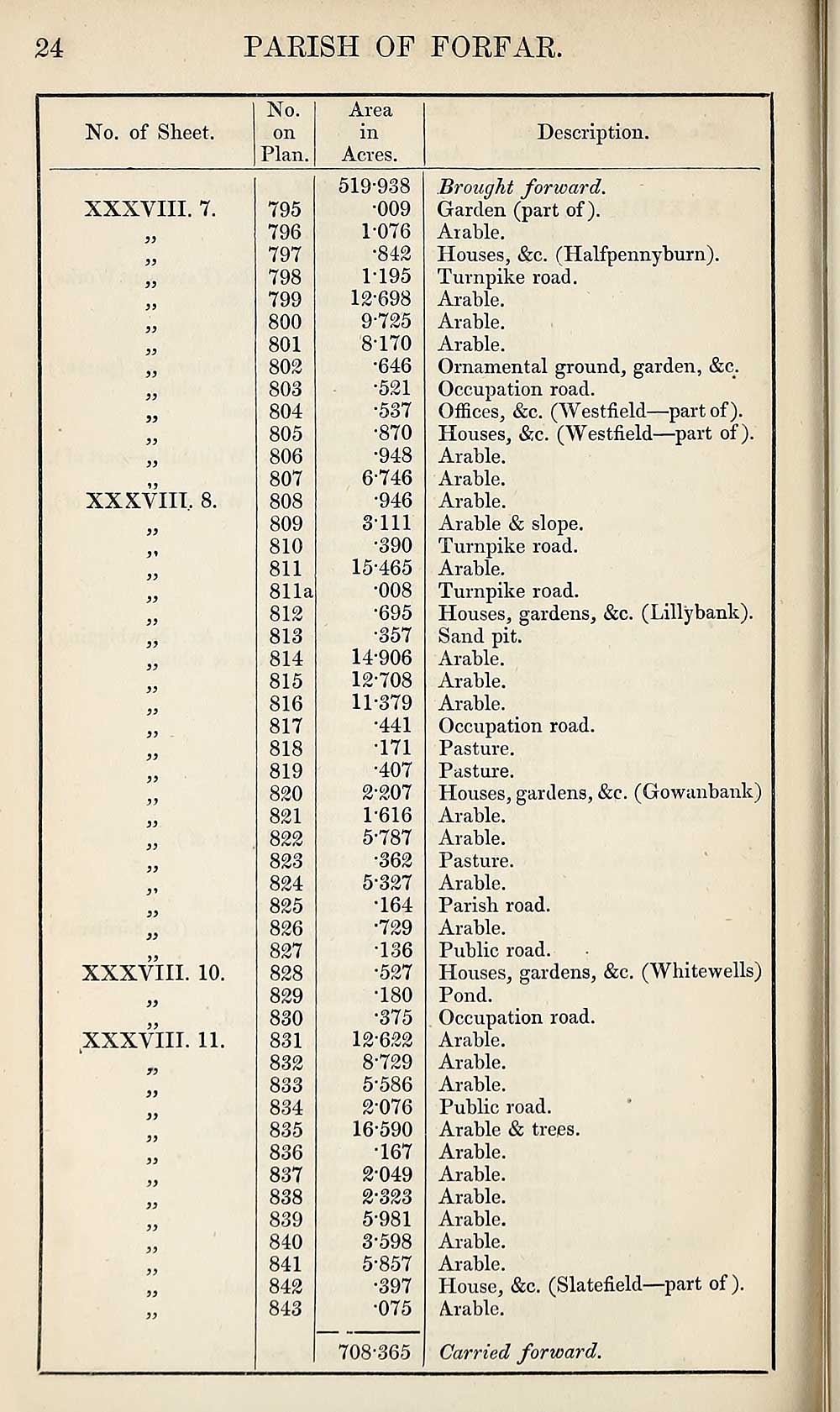
24
PARISH OF FORFAR.
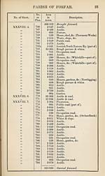
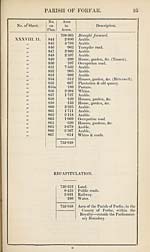
No. of Sheet.
No.
on
Plan.
Area
in
Acres.
Description.
XXXVIII. 7.
>3
93
39
99
XXXVIII. 8.
XXXVIII. 10.
XXXVIII. 11.
79
39
39
99
795
796
797
798
799
800
801
802
803
804
805
806
807
808
809
810
811
811a
812
813
814
815
816
817
818
819
820
821
822
823
824
825
826
827
828
829
830
831
832
833
834
835
836
837
838
839
840
841
842
843
519-938
•009
1-076
•842
1- 195
12-698
9-725
8170
•646
•521
•537
•870
•948
6-746
•946
3111
•390
15- 465
•008
•695
•357
14-906
12-708
11- 379
•441
171
•407
2- 207
1-616
5-787
•362
5-327
•164
•729
•136
•527
•180
•375
12- 622
8-729
5*586
2-076
16- 590
•167
2-049
2- 323
5-981
3- 598
5-857
•397
•075
708-365
Brought forward.
Garden (part of).
Arable.
Houses, &c. (Halfpennyburn).
Turnpike road.
Arable.
Arable.
Arable.
Ornamental ground, garden, &c/
Occupation road.
Offices, &c. (Westfield—part of).
Houses, &c. (Westfield—part of).
Arable.
Arable.
Arable.
Arable & slope.
Turnpike road.
Arable.
Turnpike road.
Houses, gardens, &c. (Lillybank).
Sand pit.
Arable.
Arable.
Arable.
Occupation road.
Pasture.
Pasture.
Houses, gardens, &e. (Gowanbank)
Arable.
Arable.
Pasture.
Arable.
Parish road.
Arable.
Public road.
Houses, gardens, &c. (Whitewells)
Pond.
Occupation road.
Arable.
Arable.
Arable.
Public road.
Arable & trees.
Arable.
Arable.
Arable.
Arable.
Arable.
Arable.
House, &c. (Slatefield—part of ).
Arable.
Carried forward.
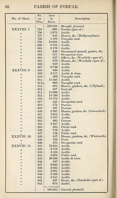
PARISH OF FORFAR.
No. of Sheet.
No.
on
Plan.
Area
in
Acres.
Description.
XXXVIII. 7.
>3
93
39
99
XXXVIII. 8.
XXXVIII. 10.
XXXVIII. 11.
79
39
39
99
795
796
797
798
799
800
801
802
803
804
805
806
807
808
809
810
811
811a
812
813
814
815
816
817
818
819
820
821
822
823
824
825
826
827
828
829
830
831
832
833
834
835
836
837
838
839
840
841
842
843
519-938
•009
1-076
•842
1- 195
12-698
9-725
8170
•646
•521
•537
•870
•948
6-746
•946
3111
•390
15- 465
•008
•695
•357
14-906
12-708
11- 379
•441
171
•407
2- 207
1-616
5-787
•362
5-327
•164
•729
•136
•527
•180
•375
12- 622
8-729
5*586
2-076
16- 590
•167
2-049
2- 323
5-981
3- 598
5-857
•397
•075
708-365
Brought forward.
Garden (part of).
Arable.
Houses, &c. (Halfpennyburn).
Turnpike road.
Arable.
Arable.
Arable.
Ornamental ground, garden, &c/
Occupation road.
Offices, &c. (Westfield—part of).
Houses, &c. (Westfield—part of).
Arable.
Arable.
Arable.
Arable & slope.
Turnpike road.
Arable.
Turnpike road.
Houses, gardens, &c. (Lillybank).
Sand pit.
Arable.
Arable.
Arable.
Occupation road.
Pasture.
Pasture.
Houses, gardens, &e. (Gowanbank)
Arable.
Arable.
Pasture.
Arable.
Parish road.
Arable.
Public road.
Houses, gardens, &c. (Whitewells)
Pond.
Occupation road.
Arable.
Arable.
Arable.
Public road.
Arable & trees.
Arable.
Arable.
Arable.
Arable.
Arable.
Arable.
House, &c. (Slatefield—part of ).
Arable.
Carried forward.
Set display mode to:
![]() Universal Viewer |
Universal Viewer | ![]() Mirador |
Large image | Transcription
Mirador |
Large image | Transcription
Images and transcriptions on this page, including medium image downloads, may be used under the Creative Commons Attribution 4.0 International Licence unless otherwise stated. ![]()
| Ordnance Survey Books of Reference 1855-1882 > Eday -- Forfar > (684) Page 24 |
|---|
| Permanent URL | https://digital.nls.uk/99272407 |
|---|
| Attribution and copyright: |
|
|---|---|
| Description | These volumes record acreages of fields and land-use information for each parish in Scotland from 1855-1882. They were compiled with the Ordnance Survey 25 inch to the mile maps for that period, which cover all the inhabited parts of Scotland. Numbered land parcels on these maps, listed consecutively within each parish, are included in the relevant parish Book of Reference. |
|---|---|
| Shelfmark | Map.Ref.C18 |
| Additional NLS resources: | |