Eday -- Forfar
(682) Page 22
Download files
Complete book:
Individual page:
Thumbnail gallery: Grid view | List view
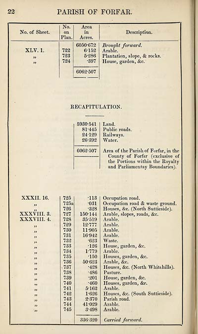
22
PARISH OF FORFAR.
No. of Sheet.
No.
on
Plan.
Area
in
Acres.
Description.
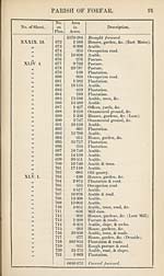
XLV. 1.
))
»
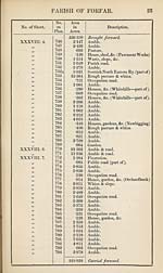
XXXII. 16.
XXXVIII. 3.
XXXVIII. 4.
3)
33
33
33
33
33
33
33
33
33
33
722
723
724
6050-672
6-152
5-286
•397
6062-507
Brought forward.
Arable.
Plantation, slope, & rocks.
House, garden, &c.
[RECAPITULATION.
725
725a
726
727
728
729
730
731
732
733
734
735
736
737
738
739
740
741
742
743
744
745
5930-541
81-445
24T29
26-392
6062-507
•113
•031
•328
150T44
35*519
12-777
11-905
16-942
•623
•126
1-779
T50
50623
•428
•486
•201
•460
5-162
1-626
2*370
41-029
3-498
Land.
Public roads.
Railways.
Water.
Area of the Parish of Forfar, in the
County of Forfar (exclusive of
the Portions within the Royalty
and Parliamentay Boundaries).
336-320
Occupation road.
Occupation road & waste ground.
Houses, &c. (North Suttieside).
Arable, slopes, roads, &c.
Arable.
Arable.
Arable.
Arable.
Waste.
House, garden, &c.
Arable.
Houses, garden, &c.
Arable, &c.
Houses, &c. (North Whitehills).
Pasture.
House, garden, &c.
Houses, garden, &c.
Arable.
Houses, &c. (South Suttieside).
Parish road.
Arable.
Arable.
Carried forward.
PARISH OF FORFAR.
No. of Sheet.
No.
on
Plan.
Area
in
Acres.
Description.
XLV. 1.
))
»
XXXII. 16.
XXXVIII. 3.
XXXVIII. 4.
3)
33
33
33
33
33
33
33
33
33
33
722
723
724
6050-672
6-152
5-286
•397
6062-507
Brought forward.
Arable.
Plantation, slope, & rocks.
House, garden, &c.
[RECAPITULATION.
725
725a
726
727
728
729
730
731
732
733
734
735
736
737
738
739
740
741
742
743
744
745
5930-541
81-445
24T29
26-392
6062-507
•113
•031
•328
150T44
35*519
12-777
11-905
16-942
•623
•126
1-779
T50
50623
•428
•486
•201
•460
5-162
1-626
2*370
41-029
3-498
Land.
Public roads.
Railways.
Water.
Area of the Parish of Forfar, in the
County of Forfar (exclusive of
the Portions within the Royalty
and Parliamentay Boundaries).
336-320
Occupation road.
Occupation road & waste ground.
Houses, &c. (North Suttieside).
Arable, slopes, roads, &c.
Arable.
Arable.
Arable.
Arable.
Waste.
House, garden, &c.
Arable.
Houses, garden, &c.
Arable, &c.
Houses, &c. (North Whitehills).
Pasture.
House, garden, &c.
Houses, garden, &c.
Arable.
Houses, &c. (South Suttieside).
Parish road.
Arable.
Arable.
Carried forward.
Set display mode to:
![]() Universal Viewer |
Universal Viewer | ![]() Mirador |
Large image | Transcription
Mirador |
Large image | Transcription
Images and transcriptions on this page, including medium image downloads, may be used under the Creative Commons Attribution 4.0 International Licence unless otherwise stated. ![]()
| Ordnance Survey Books of Reference 1855-1882 > Eday -- Forfar > (682) Page 22 |
|---|
| Permanent URL | https://digital.nls.uk/99272383 |
|---|
| Attribution and copyright: |
|
|---|---|
| Description | These volumes record acreages of fields and land-use information for each parish in Scotland from 1855-1882. They were compiled with the Ordnance Survey 25 inch to the mile maps for that period, which cover all the inhabited parts of Scotland. Numbered land parcels on these maps, listed consecutively within each parish, are included in the relevant parish Book of Reference. |
|---|---|
| Shelfmark | Map.Ref.C18 |
| Additional NLS resources: | |