Eday -- Forfar
(23) Page 9
Download files
Complete book:
Individual page:
Thumbnail gallery: Grid view | List view
PARISH OF EDAT.
9
No. of Sheet
and Plan
and No. on Plan.
Area in
Acres.
No. of Sheet
and Plan
and No. on Plan.
Area in
Acres.
No. of Sheet
and Plan
and No. on Plan.
Area in
Acres.
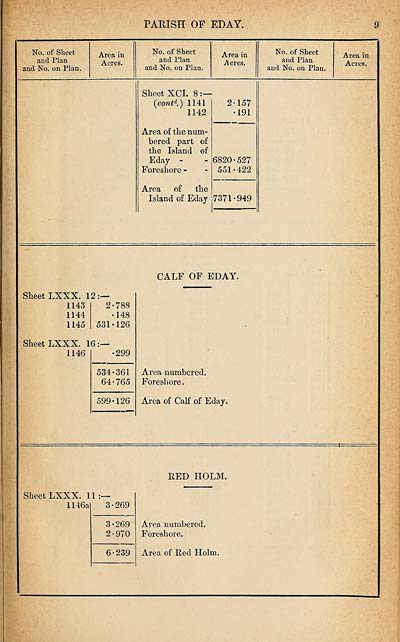
Sheet XCI. 8
(contd.) 1141
1142
Area of the num¬
bered part of
the Island of
Eday -
Foreshore -
Area of the
Island of Eday
157
191
6820-527
551-422
7371-949
CALF OF EDAY.
Sheet LXXX. 12:—
1143
1144
1145
2-788
•148
531-126
Sheet LXXX. 16:—
1146
-299
534-361
64-765
599-126
Area numbered.
Foreshore.
Area of Calf of Eday.
RED HOLM.
Sheet LXXX. 11:—
1146a
3-269
3-269
2-970
6-239
Area numbered.
Foreshore.
Area of Red Holm.
9
No. of Sheet
and Plan
and No. on Plan.
Area in
Acres.
No. of Sheet
and Plan
and No. on Plan.
Area in
Acres.
No. of Sheet
and Plan
and No. on Plan.
Area in
Acres.
Sheet XCI. 8
(contd.) 1141
1142
Area of the num¬
bered part of
the Island of
Eday -
Foreshore -
Area of the
Island of Eday
157
191
6820-527
551-422
7371-949
CALF OF EDAY.
Sheet LXXX. 12:—
1143
1144
1145
2-788
•148
531-126
Sheet LXXX. 16:—
1146
-299
534-361
64-765
599-126
Area numbered.
Foreshore.
Area of Calf of Eday.
RED HOLM.
Sheet LXXX. 11:—
1146a
3-269
3-269
2-970
6-239
Area numbered.
Foreshore.
Area of Red Holm.
Set display mode to:
![]() Universal Viewer |
Universal Viewer | ![]() Mirador |
Large image | Transcription
Mirador |
Large image | Transcription
Images and transcriptions on this page, including medium image downloads, may be used under the Creative Commons Attribution 4.0 International Licence unless otherwise stated. ![]()
| Ordnance Survey Books of Reference 1855-1882 > Eday -- Forfar > (23) Page 9 |
|---|
| Permanent URL | https://digital.nls.uk/99265051 |
|---|
| Attribution and copyright: |
|
|---|---|
| Description | These volumes record acreages of fields and land-use information for each parish in Scotland from 1855-1882. They were compiled with the Ordnance Survey 25 inch to the mile maps for that period, which cover all the inhabited parts of Scotland. Numbered land parcels on these maps, listed consecutively within each parish, are included in the relevant parish Book of Reference. |
|---|---|
| Shelfmark | Map.Ref.C18 |
| Additional NLS resources: | |