Drymen -- Eckford
(390) Page 20
Download files
Complete book:
Individual page:
Thumbnail gallery: Grid view | List view
20
PARISH OF DUNNICHEN
No. of Sheet.
No.
on
Plan.
Area
in
Acres.
Description.
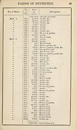
XLV. 2.
39
99
39
99
39
39
99
99
39
99
39
99
39
99
33
39
XLV. 5.
XLV. 6.
99
99
93
99
99
39
99
99
39
39
39
99
99
99
39
631
632
633
634
635
636
637
638
639
640
641
642
643
644
645
646
646a
647
648
649
650
651
652
653
654
655
656
657
658
659
660
661
662
663
664
665
666
667
3606-506
40-291
1-646
1- 117
4-733
•750
•180
13- 437
•082
2*906
4-632
8- 256
•184
2- 449
1- 215
•899
27-957
12-580
2- 070
•285
•141
14- 835
194-217
4-262
11- 287
12- 184
18-466
9- 943
•140
•584
3- 257
9-914
12-206
33-450
6- 672
12-275
10-179
•090
7- 798
4094-075
Brought forward.
Arable.
Houses, garden, yards, &c.
Pasture.
Arable, &c.
Occupation road.
Mill dam.
Arable, &c.
House & garden.
Occupation road.
Fir plantation.
Arable.
House & garden.
Public road.
Arable.
Plouses, garden, &c.
Arable.
Arable.
Public road.
Occupation road.
House, garden, &c.
Arable.
Fir plantation.
Arable.
Arable.
Arable.
Arable.
Arable.
Houses & garden.
Plouses, garden, &c.
Arable.
Arable, &c.
Arable.
Fir plantation.
Fir plantation.
Arable.
Arable, &c.
Plouses & garden.
Arable, &c.
RECAPITULATION.
4027-759
4-633
6P683
4094-075
Land.
Water.
Public Roads.
Area of the Parish of Dunnichen,
(exclusive of Detached Portion).
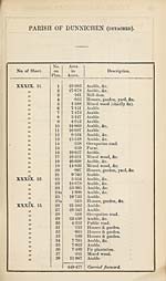
PARISH OF DUNNICHEN
No. of Sheet.
No.
on
Plan.
Area
in
Acres.
Description.
XLV. 2.
39
99
39
99
39
39
99
99
39
99
39
99
39
99
33
39
XLV. 5.
XLV. 6.
99
99
93
99
99
39
99
99
39
39
39
99
99
99
39
631
632
633
634
635
636
637
638
639
640
641
642
643
644
645
646
646a
647
648
649
650
651
652
653
654
655
656
657
658
659
660
661
662
663
664
665
666
667
3606-506
40-291
1-646
1- 117
4-733
•750
•180
13- 437
•082
2*906
4-632
8- 256
•184
2- 449
1- 215
•899
27-957
12-580
2- 070
•285
•141
14- 835
194-217
4-262
11- 287
12- 184
18-466
9- 943
•140
•584
3- 257
9-914
12-206
33-450
6- 672
12-275
10-179
•090
7- 798
4094-075
Brought forward.
Arable.
Houses, garden, yards, &c.
Pasture.
Arable, &c.
Occupation road.
Mill dam.
Arable, &c.
House & garden.
Occupation road.
Fir plantation.
Arable.
House & garden.
Public road.
Arable.
Plouses, garden, &c.
Arable.
Arable.
Public road.
Occupation road.
House, garden, &c.
Arable.
Fir plantation.
Arable.
Arable.
Arable.
Arable.
Arable.
Houses & garden.
Plouses, garden, &c.
Arable.
Arable, &c.
Arable.
Fir plantation.
Fir plantation.
Arable.
Arable, &c.
Plouses & garden.
Arable, &c.
RECAPITULATION.
4027-759
4-633
6P683
4094-075
Land.
Water.
Public Roads.
Area of the Parish of Dunnichen,
(exclusive of Detached Portion).
Set display mode to:
![]() Universal Viewer |
Universal Viewer | ![]() Mirador |
Large image | Transcription
Mirador |
Large image | Transcription
Images and transcriptions on this page, including medium image downloads, may be used under the Creative Commons Attribution 4.0 International Licence unless otherwise stated. ![]()
| Ordnance Survey Books of Reference 1855-1882 > Drymen -- Eckford > (390) Page 20 |
|---|
| Permanent URL | https://digital.nls.uk/99261243 |
|---|
| Attribution and copyright: |
|
|---|---|
| Description | These volumes record acreages of fields and land-use information for each parish in Scotland from 1855-1882. They were compiled with the Ordnance Survey 25 inch to the mile maps for that period, which cover all the inhabited parts of Scotland. Numbered land parcels on these maps, listed consecutively within each parish, are included in the relevant parish Book of Reference. |
|---|---|
| Shelfmark | Map.Ref.C18 |
| Additional NLS resources: | |