Drymen -- Eckford
(204) Page 6
Thumbnail gallery: Grid view | List view
6
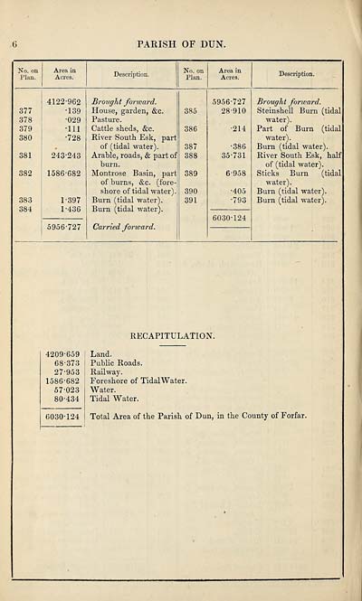
PARISH OF DUN.
No. on
Plan.
Area in
Acres.
Description.
No. on
Plan.
Area in
Acres.
Description.
377
378
379
380
381
382
383
384
4122-962
•139
•029
•111
•728
243-243
1586-682
1-397
1-436
5956-727
Brought forward.
House, garden, &c.
Pasture.
Cattle sheds, &c.
River South Esk, part
of (tidal water).
Arable, roads, & part of
burn.
Montrose Basin, part
of burns, &c. (fore-,
shore of tidal water).
Burn (tidal water).
Burn (tidal water).
Carried forward.
385
386
387
388
389
390
391
5956-727
28-910
•214
■386
35-731
6-958
•405
•793
6030-124
Brought forward.
Steinshell Burn (tidal
water).
Part of Burn (tidal
water).
Burn (tidal water).
River South Esk, half
of (tidal water).
Sticks Burn (tidal
water).
Burn (tidal water).
Burn (tidal water).
RECAPITULATION.
4209-659
68-373
27-953
1586-682
57-023
80-434
6030-124
Land.
Public Roads.
Railway.
Foreshore of Tidal Water.
Water.
Tidal Water.
Total Area of the Parish of Dun, in the County of Forfar.
Set display mode to:
![]() Universal Viewer |
Universal Viewer | ![]() Mirador |
Large image | Transcription
Mirador |
Large image | Transcription
Images and transcriptions on this page, including medium image downloads, may be used under the Creative Commons Attribution 4.0 International Licence unless otherwise stated. ![]()
| Ordnance Survey Books of Reference 1855-1882 > Drymen -- Eckford > (204) Page 6 |
|---|
| Permanent URL | https://digital.nls.uk/99259179 |
|---|
| Attribution and copyright: |
|
|---|---|
| Description | These volumes record acreages of fields and land-use information for each parish in Scotland from 1855-1882. They were compiled with the Ordnance Survey 25 inch to the mile maps for that period, which cover all the inhabited parts of Scotland. Numbered land parcels on these maps, listed consecutively within each parish, are included in the relevant parish Book of Reference. |
|---|---|
| Shelfmark | Map.Ref.C18 |
| Additional NLS resources: | |