Drymen -- Eckford
(181) Page 17
Download files
Complete book:
Individual page:
Thumbnail gallery: Grid view | List view

PARISH OF DUMBARTON.
17
No. of Sheet.
No.
on
Flan,
Area
m
Acres.
Description.
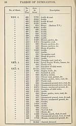
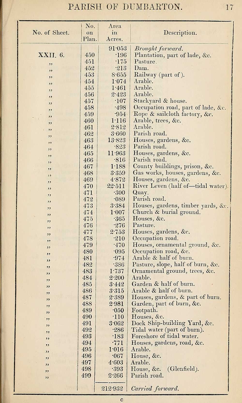
XXII. 6.
7)
ii
77
77
77
450
451
452
453
454
455
456
457
458
459
460
461
462
463
464
465
466
467
468
469
470
471
472
473
474
475
476
477
478
479
480
481
482
483
484
485
486
487
488
489
490
491
492
493
494
495
496
497
498
499
91*053
•196
175
•213
8-655
1074
1- 461
2‘423
•107
•498
•954
M16
2- 812
3-660
13-823
•823
11-963
•816
1-188
3- 359
4- 872
22-511
•300
•089
3-384
1- 007
•365
•276
2- 753
•210
•470
•095
•974
•386
1- 737
2- 200
3- 442
3-315
2-389
2- 981
•050
•110
3- 062
-286
•183
•771
1-016
•067
4- 603
•393
2-266
212-932
Brought forward.
Plantation, part of lade, &c.
Pasture,
Dam.
Railway (part of).
Arable.
Arable.
Arable.
Stackyard & bouse.
Occupation road, part of lade, Ac.
Rope & sailcloth factory, &c.
Arable, trees, &c.
Arable.
Parish road.
Houses, gardens, &c.
Parish road.
Houses, gardens, &c.
Parish road.
County buildings, prison, &c.
Gas works, bouses, gardens, &c.
Houses, gardens, Ac.
River Leven (half of—tidal water).
Quay.
Parish road.
Houses, gardens, timber yards, &c.
Church A burial ground.
Houses, Ac.
Pasture.
Houses, gardens, Ac.
Occupation road.
Houses, ornamental ground, Ac.
Occupation road, Ac.
Arable A half of burn.
Pasture, slope, half of burn, Ac.
Ornamental ground, trees, Ac.
Arable.
Garden A half of burn.
Arable A half of burn.
Houses, gardens, A part of burn.
Garden, part of burn, Ac.
Footpath.
Houses, Ac.
Dock Ship-building Yard, Ac.
Tidal water (part of burn).
Foreshore of tidal water.
Houses, gardens, road, Ac.
Arable.
House, Ac.
Arable.
House, Ac. (Glenfield).
Parish road.
Carried forward.
c
17
No. of Sheet.
No.
on
Flan,
Area
m
Acres.
Description.
XXII. 6.
7)
ii
77
77
77
450
451
452
453
454
455
456
457
458
459
460
461
462
463
464
465
466
467
468
469
470
471
472
473
474
475
476
477
478
479
480
481
482
483
484
485
486
487
488
489
490
491
492
493
494
495
496
497
498
499
91*053
•196
175
•213
8-655
1074
1- 461
2‘423
•107
•498
•954
M16
2- 812
3-660
13-823
•823
11-963
•816
1-188
3- 359
4- 872
22-511
•300
•089
3-384
1- 007
•365
•276
2- 753
•210
•470
•095
•974
•386
1- 737
2- 200
3- 442
3-315
2-389
2- 981
•050
•110
3- 062
-286
•183
•771
1-016
•067
4- 603
•393
2-266
212-932
Brought forward.
Plantation, part of lade, &c.
Pasture,
Dam.
Railway (part of).
Arable.
Arable.
Arable.
Stackyard & bouse.
Occupation road, part of lade, Ac.
Rope & sailcloth factory, &c.
Arable, trees, &c.
Arable.
Parish road.
Houses, gardens, &c.
Parish road.
Houses, gardens, &c.
Parish road.
County buildings, prison, &c.
Gas works, bouses, gardens, &c.
Houses, gardens, Ac.
River Leven (half of—tidal water).
Quay.
Parish road.
Houses, gardens, timber yards, &c.
Church A burial ground.
Houses, Ac.
Pasture.
Houses, gardens, Ac.
Occupation road.
Houses, ornamental ground, Ac.
Occupation road, Ac.
Arable A half of burn.
Pasture, slope, half of burn, Ac.
Ornamental ground, trees, Ac.
Arable.
Garden A half of burn.
Arable A half of burn.
Houses, gardens, A part of burn.
Garden, part of burn, Ac.
Footpath.
Houses, Ac.
Dock Ship-building Yard, Ac.
Tidal water (part of burn).
Foreshore of tidal water.
Houses, gardens, road, Ac.
Arable.
House, Ac.
Arable.
House, Ac. (Glenfield).
Parish road.
Carried forward.
c
Set display mode to:
![]() Universal Viewer |
Universal Viewer | ![]() Mirador |
Large image | Transcription
Mirador |
Large image | Transcription
Images and transcriptions on this page, including medium image downloads, may be used under the Creative Commons Attribution 4.0 International Licence unless otherwise stated. ![]()
| Ordnance Survey Books of Reference 1855-1882 > Drymen -- Eckford > (181) Page 17 |
|---|
| Permanent URL | https://digital.nls.uk/99258927 |
|---|
| Attribution and copyright: |
|
|---|---|
| Description | These volumes record acreages of fields and land-use information for each parish in Scotland from 1855-1882. They were compiled with the Ordnance Survey 25 inch to the mile maps for that period, which cover all the inhabited parts of Scotland. Numbered land parcels on these maps, listed consecutively within each parish, are included in the relevant parish Book of Reference. |
|---|---|
| Shelfmark | Map.Ref.C18 |
| Additional NLS resources: | |