Drymen -- Eckford
(179) Page 15
Download files
Complete book:
Individual page:
Thumbnail gallery: Grid view | List view
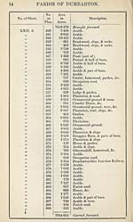
PARISH OF DUMBARTON
15
No. of Sheet.
No.
on
Plan.
Area
in
Acres.
Description.
XXII. 6.
XXII. 7.
XXII. 10.
390
391
392
393
394
395
396
397
398
399
7954*665
2-203
*894
•708
2*066
*052
*102
*195
•040
•698
30*295
7991-918
Brought forward.
Arable.
Arable.
Turnpike road.
Arable.
Arable.
Garden (part of).
Occupation road.
Pasture.
Arable.
River Clyde (half of—tidal water).
RECAPITULATION.
7828*644
13*680
T214
68-007
22-324
58-049
7991*918
Land.
Public roads.
Railway.
Water.
Foreshore of tidal water.
Tidal water.
Area of the Parish of Dumbarton,
(exclusive of that portion within
the Parliamentary Boundary).
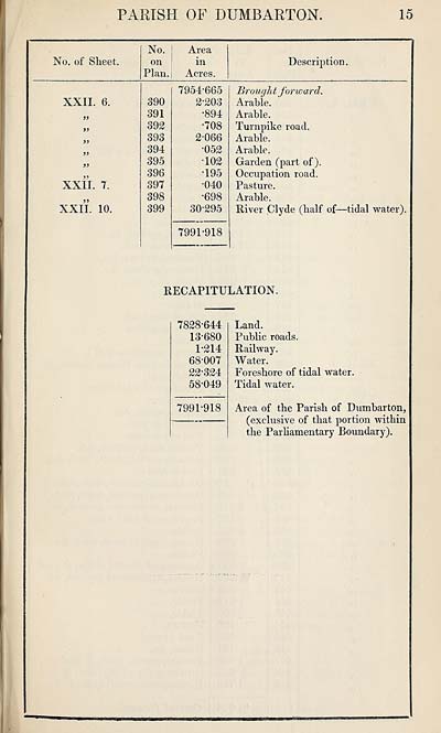
Set display mode to:
![]() Universal Viewer |
Universal Viewer | ![]() Mirador |
Large image | Transcription
Mirador |
Large image | Transcription
Images and transcriptions on this page, including medium image downloads, may be used under the Creative Commons Attribution 4.0 International Licence unless otherwise stated. ![]()
| Ordnance Survey Books of Reference 1855-1882 > Drymen -- Eckford > (179) Page 15 |
|---|
| Permanent URL | https://digital.nls.uk/99258903 |
|---|
| Attribution and copyright: |
|
|---|---|
| Description | These volumes record acreages of fields and land-use information for each parish in Scotland from 1855-1882. They were compiled with the Ordnance Survey 25 inch to the mile maps for that period, which cover all the inhabited parts of Scotland. Numbered land parcels on these maps, listed consecutively within each parish, are included in the relevant parish Book of Reference. |
|---|---|
| Shelfmark | Map.Ref.C18 |
| Additional NLS resources: | |