Drymen -- Eckford
(177) Page 13
Download files
Complete book:
Individual page:
Thumbnail gallery: Grid view | List view
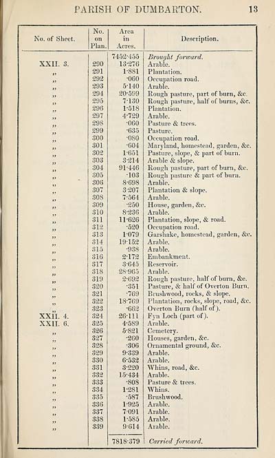
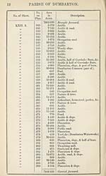
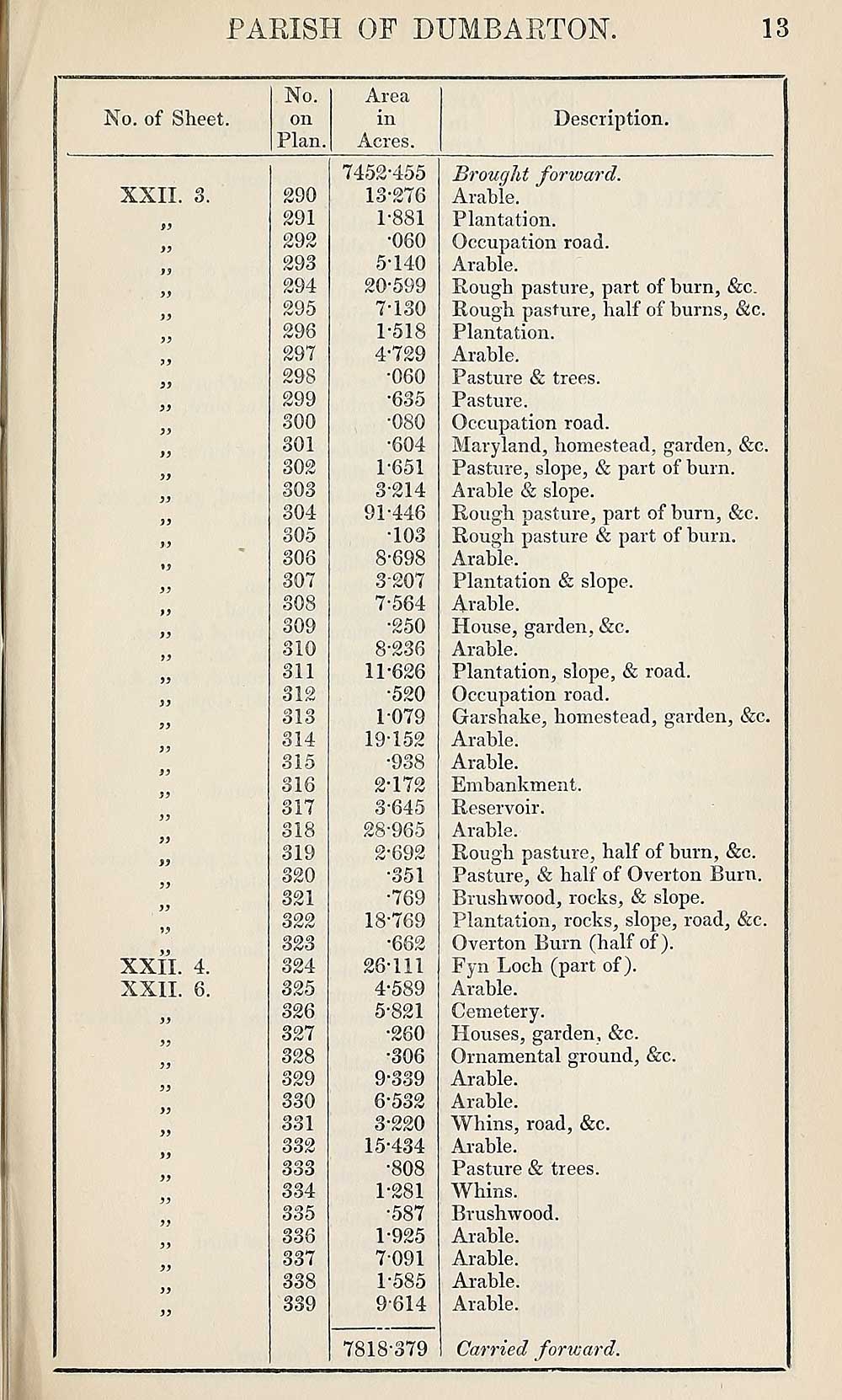
PARISH OF DUMBARTON.
13
No. of Sheet.
No.
on
Plan.
Area
in
Acres.
Description.
XXII. s.
)}
3)
33
33
33
XXII. 4.
XXII. 6.
290
291
292
293
294
295
296
297
298
299
300
301
302
303
304
305
306
307
308
309
310
311
312
CT 1 O
olo
314
315
316
317
318
319
320
321
322
324
325
326
327
328
329
330
331
332
333
334
335
336
337
338
339
7452-455
13-276
1-881
•060
5-140
20-599
7-130
1-518
4-729
•060
•635
•604
1-651
3-214
91-446
•103
8-698
3-207
7- 564
•250
8- 236
11-626
•520
1- 079
19-152
•938
2- 172
3- 645
28-965
2- 692
•351
•769
18-769
•662
26-111
4- 589
5- 821
•260
•306
9- 339
6- 532
3- 220
15-434
•808
1-281
•587
1-925
7- 091
1-585
9-614
7818-379
Brought forward.
Arable.
Plantation.
Occupation road.
Arable.
Rough pasture, part of burn, &c.
Rough pasture, half of burns, &c.
Plantation.
Arable.
Pasture & trees.
Pasture.
Occupation road.
Maryland, homestead, garden, &c.
Pasture, slope, & part of burn.
Arable & slope.
Rough pasture, part of burn, &c.
Rough pasture & part of burn.
Arable.
Plantation & slope.
Arable.
House, garden, &c.
Arable.
Plantation, slope, & road.
Occupation road.
Garshake, homestead, garden, &c.
Arable.
Arable.
Embankment.
Reservoir.
Arable.
Rough pasture, half of burn, &c.
Pasture, & half of Overton Burn.
Brushwood, rocks, & slope.
Plantation, rocks, slope, road, &c.
Overton Bum (half of).
Fyn Loch (part of).
Arable.
Cemetery.
Houses, garden, &c.
Ornamental ground, &c.
Arable.
Arable.
Whins, road, &c.
Arable.
Pasture & trees.
Whins.
Brushwood.
Arable.
Arable.
Arable.
Arable.
Carried forward.
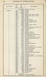
Set display mode to:
![]() Universal Viewer |
Universal Viewer | ![]() Mirador |
Large image | Transcription
Mirador |
Large image | Transcription
Images and transcriptions on this page, including medium image downloads, may be used under the Creative Commons Attribution 4.0 International Licence unless otherwise stated. ![]()
| Ordnance Survey Books of Reference 1855-1882 > Drymen -- Eckford > (177) Page 13 |
|---|
| Permanent URL | https://digital.nls.uk/99258879 |
|---|
| Attribution and copyright: |
|
|---|---|
| Description | These volumes record acreages of fields and land-use information for each parish in Scotland from 1855-1882. They were compiled with the Ordnance Survey 25 inch to the mile maps for that period, which cover all the inhabited parts of Scotland. Numbered land parcels on these maps, listed consecutively within each parish, are included in the relevant parish Book of Reference. |
|---|---|
| Shelfmark | Map.Ref.C18 |
| Additional NLS resources: | |