Chapel of Garioch -- Cruden
(454) Page 24
![[Page 25]](https://deriv.nls.uk/dcn4/9924/99245409.4.jpg)
Download files
Complete book:
Individual page:
Thumbnail gallery: Grid view | List view
24
PARISH OF CRAWFORD.
No. of Sheet.
No.
on
Plan.
Area
in
Acres.
Description.
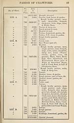
LIII. D.
})
LV. A.
LV. B.
755
756
757
758
759
760
761
762
763
'61
67678*069 Brought forward.
S'Slo Pasture.
10,339 Rough pasture, road, &c.
4-041 Pasture, road, house, & garden.
2‘658 Rough heathy pasture & slope.
6*272 Rough pasture.
3*568 Rough heathy pasture & footpath.
1*400 Pasture.
*883 Pasture.
Rough heathy pasture, rough
pasture, rocks, footpath, Row-
1122‘589 <( antree Grain, half of Crook
Burn, part of Daer Water, &
sheep rees.
4*110 Pasture.
68839*442
RECAPITULATION.
Land.
Public roads.
Railway.
Water.
Total area of the Parish of Craw¬
ford, in the County of Lanark.
68222*493
172*351
131*402
313*196
68839*442
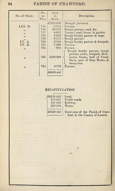
PARISH OF CRAWFORD.
No. of Sheet.
No.
on
Plan.
Area
in
Acres.
Description.
LIII. D.
})
LV. A.
LV. B.
755
756
757
758
759
760
761
762
763
'61
67678*069 Brought forward.
S'Slo Pasture.
10,339 Rough pasture, road, &c.
4-041 Pasture, road, house, & garden.
2‘658 Rough heathy pasture & slope.
6*272 Rough pasture.
3*568 Rough heathy pasture & footpath.
1*400 Pasture.
*883 Pasture.
Rough heathy pasture, rough
pasture, rocks, footpath, Row-
1122‘589 <( antree Grain, half of Crook
Burn, part of Daer Water, &
sheep rees.
4*110 Pasture.
68839*442
RECAPITULATION.
Land.
Public roads.
Railway.
Water.
Total area of the Parish of Craw¬
ford, in the County of Lanark.
68222*493
172*351
131*402
313*196
68839*442
Set display mode to:
![]() Universal Viewer |
Universal Viewer | ![]() Mirador |
Large image | Transcription
Mirador |
Large image | Transcription
Images and transcriptions on this page, including medium image downloads, may be used under the Creative Commons Attribution 4.0 International Licence unless otherwise stated. ![]()
| Ordnance Survey Books of Reference 1855-1882 > Chapel of Garioch -- Cruden > (454) Page 24 |
|---|
| Permanent URL | https://digital.nls.uk/99245395 |
|---|
| Attribution and copyright: |
|
|---|---|
| Description | These volumes record acreages of fields and land-use information for each parish in Scotland from 1855-1882. They were compiled with the Ordnance Survey 25 inch to the mile maps for that period, which cover all the inhabited parts of Scotland. Numbered land parcels on these maps, listed consecutively within each parish, are included in the relevant parish Book of Reference. |
|---|---|
| Shelfmark | Map.Ref.C18 |
| Additional NLS resources: | |