Chapel of Garioch -- Cruden
(448) Page 18
Download files
Complete book:
Individual page:
Thumbnail gallery: Grid view | List view
18
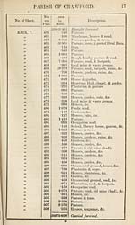
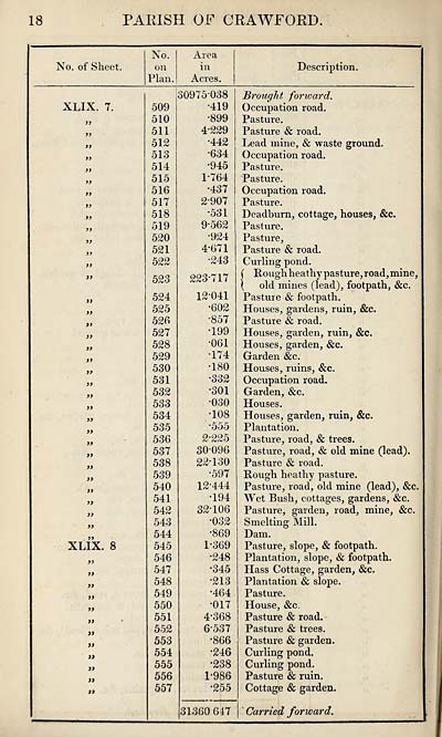
PARISH OP CRAWFORD.
No. of Sheet.
No.
on
Plan.
Area
in
Acres.
Description.
XLIX. 7.
»
>>
»
tf
y>
>>
»>
>>
y>
a
3>
y»
a
i>
a
)f
XLIX. 8
3i
33
33
33
33
33
33
33
33
33
33
33
509
510
511
512
513
514
515
516
517
518
519
520
521
522
523
524
525
526
527
528
529
530
531
532
533
534
535
536
537
538
539
540
541
542
543
544
545
546
547
548
549
550
551
552
553
554
555
556
557
30975-038
•419
•899
4*229
•442
•634
•945
1- 764
•437
2907
•531
9-562
•924
4-671
•243
223*717
12041
•602
•857
•199
•061
•174
•180
•332
•301
•030
•108
*555
2- 225
30-096
22-130
•597
12-444
•194
32-106
•032
•869
1-369
•248
•345
•213
•464
•017
4-368
6-537
•866
•246
•238
1-986
•255
31360 647
Brought forward.
Occupation road.
Pasture.
Pasture & road.
Lead mine, & waste ground.
Occupation road.
Pasture.
Pasture.
Occupation road.
Pasture.
Deadburn, cottage, houses, &c.
Pasture.
Pasture,
Pasture & road.
Curling pond.
{ Hough heathy pasture, road, mine,
( old mines (lead), footpath, &c.
Pasture Sc footpath.
Houses, gardens, ruin, &c.
Pasture & road.
Houses, garden, ruin, &c.
Houses, garden, &c.
Garden &c.
Houses, ruins, &c.
Occupation road.
Garden, &c.
Houses.
Houses, garden, ruin, &c.
Plantation.
Pasture, road, & trees.
Pasture, road, & old mine (lead).
Pasture & road.
Rough heathy pasture.
Pasture, road, old mine (lead), &c.
Wet Bush, cottages, gardens, &c.
Pasture, garden, road, mine, &c.
Smelting Mill.
Dam.
Pasture, slope, & footpath.
Plantation, slope, & footpath.
Hass Cottage, garden, &c.
Plantation & slope.
Pasture.
House, &c.
Pasture & road.
Pasture & trees.
Pasture & garden.
Curling pond.
Curling pond.
Pasture & ruin.
Cottage & garden.
Carried forward.
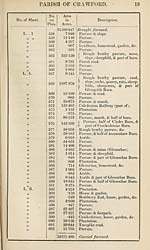
Set display mode to:
![]() Universal Viewer |
Universal Viewer | ![]() Mirador |
Large image | Transcription
Mirador |
Large image | Transcription
Images and transcriptions on this page, including medium image downloads, may be used under the Creative Commons Attribution 4.0 International Licence unless otherwise stated. ![]()
| Ordnance Survey Books of Reference 1855-1882 > Chapel of Garioch -- Cruden > (448) Page 18 |
|---|
| Permanent URL | https://digital.nls.uk/99245323 |
|---|
| Attribution and copyright: |
|
|---|---|
| Description | These volumes record acreages of fields and land-use information for each parish in Scotland from 1855-1882. They were compiled with the Ordnance Survey 25 inch to the mile maps for that period, which cover all the inhabited parts of Scotland. Numbered land parcels on these maps, listed consecutively within each parish, are included in the relevant parish Book of Reference. |
|---|---|
| Shelfmark | Map.Ref.C18 |
| Additional NLS resources: | |