Chapel of Garioch -- Cruden
(437) [Page 7]

Download files
Complete book:
Individual page:
Thumbnail gallery: Grid view | List view
![(437) [Page 7] -](https://deriv.nls.uk/dcn17/9924/99245193.17.jpg)
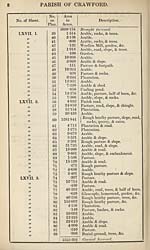
PARISH OF CRAWFORD,
IN THE
COUNTY OF LANARK.
No. of Sheet.
No.
on
Plan.
Area
in
Acres.
Description.
XLIII. 13.
»
)>
)>
3)
33
33
33
33
33
33
33
XLIII. D.
XLYI. 8.
33
33
XLVII. 1.
33
33
33
33
33
33
33
33
3
4
5
6
7
8
9
9a
10
11
12
13
14
15
16
17
18
19
20
21
22
23
24
25
23
27
28
29
30
31
32
33
34
35
36
•210
10- 759
4-709
•183
8-806
•288
•279
1 833
3-897
•173
•305
•504
•079
•515
•187
•241
3600-067
6-758
3-250
•397
1-953
•152
•858
•371
1-470
6127
1-410
1- 301
6-541
•229
•358
3-471
•416
2- 860
3-125
11- 203
11-736
•178
1-955
3699-154
Pasture.
Arable, slope, & embankment.
Arable.
Pasture.
Arable & embankment.
Occupation road, slope, &c.
Waste ground.
Arable.
Arable.
Parish road.
Plantation.
Southwood, homestead (part of),&c.
Plantation.
Southwood, homestead (part of),&c.
Plantation.
Dam.
I Rough heathy pasture, road, slope,
rocks, footpath, sheepfolds, sheep-
( rees, & part of Grains Burn.
Pasture, house, garden, &c.
Glengonnar Water (half of).
Meadow, slope, & half of burn.
Meadow & slope.
Lettershaw, house, garden, &c.
Arable & road.
Pasture.
Rough heathy pasture.
Arable & slope.
Arable.
Arable & road.
Arable & shed.
Arable.
Plantation.
Arable & slope.
Occupation road, &c.
Arable & slope.
Plantation & slope.
Arable & road.
Arable.
Pasture.
Plantation & slope.
Carried forward.
Set display mode to:
![]() Universal Viewer |
Universal Viewer | ![]() Mirador |
Large image | Transcription
Mirador |
Large image | Transcription
Images and transcriptions on this page, including medium image downloads, may be used under the Creative Commons Attribution 4.0 International Licence unless otherwise stated. ![]()
| Ordnance Survey Books of Reference 1855-1882 > Chapel of Garioch -- Cruden > (437) [Page 7] |
|---|
| Permanent URL | https://digital.nls.uk/99245191 |
|---|
| Attribution and copyright: |
|
|---|---|
| Description | These volumes record acreages of fields and land-use information for each parish in Scotland from 1855-1882. They were compiled with the Ordnance Survey 25 inch to the mile maps for that period, which cover all the inhabited parts of Scotland. Numbered land parcels on these maps, listed consecutively within each parish, are included in the relevant parish Book of Reference. |
|---|---|
| Shelfmark | Map.Ref.C18 |
| Additional NLS resources: | |