Download files
Complete book:
Individual page:
Thumbnail gallery: Grid view | List view
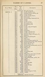
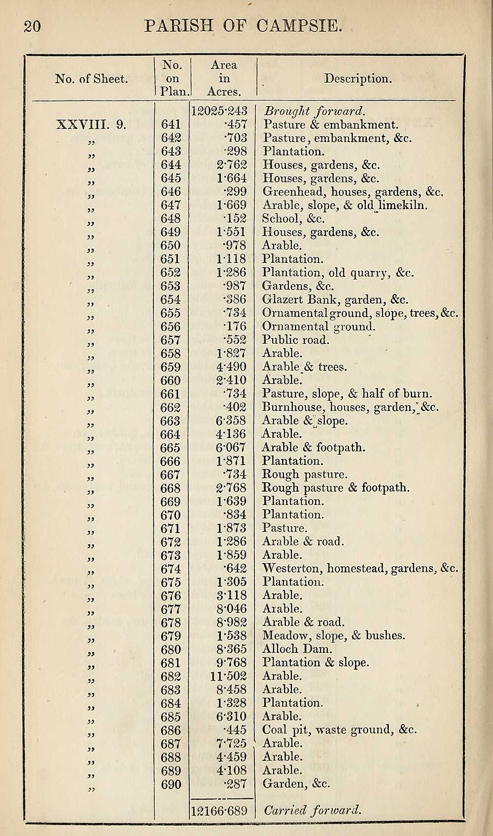
20
PARISH OF CAMPSIE
No. of Sheet.
No.
on
Plan.
Area
in
Acres.
Description.
XXVIII. 9.
5?
f)
f>
Si
S3
S3
S3
33
33
33
33
33
33
33
33
33
33
33
33
33
33
33
33
33
33
33
33
33
33
33
33
33
33
33
33
33
33
641
642
643
644
645
646
647
648
649
650
651
652
653
654
655
656
657
658
659
660
661
662
663
664
665
666
667
668
669
670
671
672
673
674
675
676
677
678
679
680
681
682
683
684
685
686
687
688
689
690
12025-243
•457
•703
•298
2-762
P664
•299
1-669
152
1-551
•978
1-118
1-286
•987
•386
•734
176
•552
1- 827
4-490
2- 410
•734
•402
6358
4-136
6-067
1- 871
•734
2- 768
1-639
•834
1-873
1-286
1-859
•642
1-305
3- 118
8-046
8-982
1-538
8- 365
9- 768
11-502
8-458
1-328
6- 310
•445
7- 725
4-459
4-108
•287
12166-689
Brought forward.
Pasture & embankment.
Pasture, embankment, &c.
Plantation.
Houses, gardens, &c.
Houses, gardens, &c.
Greenhead, houses, gardens, &c.
Arable, slope, & old limekiln.
School, &c.
Houses, gardens, &c.
Arable.
Plantation.
Plantation, old quarry, &c.
Gardens, &c.
Glazert Bank, garden, &c.
Ornamental ground, slope, trees, &c.
Ornamental ground.
Public road.
Arable.
Arable & trees.
Arable.
Pasture, slope, & half of burn.
Burnhouse, bouses, garden,^&c.
Arable & slope.
Arable.
Arable & footpath.
Plantation.
Rough pasture.
Rough pasture & footpath.
Plantation.
Plantation.
Pasture.
Arable & road.
Arable.
Westerton, homestead, gardens, &c.
Plantation.
Arable.
Arable.
Arable & road.
Meadow, slope, & bushes.
Alloch Dam.
Plantation & slope.
Arable.
Arable.
Plantation.
Arable.
Coal pit, waste ground, &c.
Arable.
Arable.
Arable.
Garden, &c.
Carried forward.
Set display mode to:
![]() Universal Viewer |
Universal Viewer | ![]() Mirador |
Large image | Transcription
Mirador |
Large image | Transcription
Images and transcriptions on this page, including medium image downloads, may be used under the Creative Commons Attribution 4.0 International Licence unless otherwise stated. ![]()
| Ordnance Survey Books of Reference 1855-1882 > Cabrach (part of) -- Cawdor (parts of) and Moy and Dalarossie (part of) > (262) Page 20 |
|---|
| Permanent URL | https://digital.nls.uk/99234711 |
|---|
| Attribution and copyright: |
|
|---|---|
| Description | These volumes record acreages of fields and land-use information for each parish in Scotland from 1855-1882. They were compiled with the Ordnance Survey 25 inch to the mile maps for that period, which cover all the inhabited parts of Scotland. Numbered land parcels on these maps, listed consecutively within each parish, are included in the relevant parish Book of Reference. |
|---|---|
| Shelfmark | Map.Ref.C18 |
| Additional NLS resources: | |