Benholm -- North Bute
(567) 1878 - Bracadale (Island of Skye), County of Inverness
Thumbnail gallery: Grid view | List view
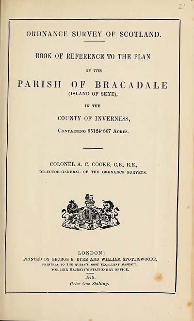
ORDNANCE SURVEY OE SCOTLAND.
BOOK OF REFERENCE TO THE PLAN
OF THE
PARISH OF BRACADALE
(ISLAND OF SKYE),
IN THE
COUNTY OF INVERNESS,
Containing 95124c867 Acres.
COLONEL A. C. COOKE, C.B., R.E.,
DIRECTOR-GENERAL OF THE ORDNANCE SURVEYS.
LONDON:
PRINTED BY GEORGE E. EYRE AND WILLIAM SPOTTISWOODE,
PRINTERS TO THE QUEEN’S MOST EXCELLENT MAJESTY.
FOR HER MAJESTY’S STATIONERY OFFICE.
1878.
Price One Shilling.
Set display mode to:
![]() Universal Viewer |
Universal Viewer | ![]() Mirador |
Large image | Transcription
Mirador |
Large image | Transcription
Images and transcriptions on this page, including medium image downloads, may be used under the Creative Commons Attribution 4.0 International Licence unless otherwise stated. ![]()
| Ordnance Survey Books of Reference 1855-1882 > Benholm -- North Bute > (567) 1878 - Bracadale (Island of Skye), County of Inverness |
|---|
| Permanent URL | https://digital.nls.uk/99230087 |
|---|---|
| Attribution and copyright: |
|
|---|---|
| Description | These volumes record acreages of fields and land-use information for each parish in Scotland from 1855-1882. They were compiled with the Ordnance Survey 25 inch to the mile maps for that period, which cover all the inhabited parts of Scotland. Numbered land parcels on these maps, listed consecutively within each parish, are included in the relevant parish Book of Reference. |
|---|---|
| Shelfmark | Map.Ref.C18 |
| Additional NLS resources: | |