Benholm -- North Bute
(361) [Page 7]

Download files
Complete book:
Individual page:
Thumbnail gallery: Grid view | List view
![(361) [Page 7] -](https://deriv.nls.uk/dcn17/9922/99227737.17.jpg)
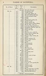
PARISH OF BOTHWELL,
IN THE
COUNTY OF LANARK.
No. of Sheet.
No.
on
Plan.
Area
in
Acres.
Description.
VII. 14.
VIE 15.
a
j}
>>
a
>>
)3
}}
)}
3}
33
33
3
4
5
6
7
8
9
10
11
12
13
14
15
16
17
18
19
20
21
09
rfV'fV
23
24
25
26
27
28
29
30
31
32
33
34
35
36
37
38
39
40
7*526
6*483
1*279
*716
*928
10*655
*278
*168
•419
1157
1*152
24-111
•646
1*341
8*935
2-760
12-237
•500
1*082
•427
3*359
7*870
6-419
1*043
5*757
*159
•678
•919
*205
1-578
8*306
21*128
1*111
•388
11-506
1- 205
2- 065
16-379
11*928
•343
185-146
Plantation, rocks, slope, &c.
Arable, slope, & trees.
Garden, &c.
Garden, slope, &c.
Wood, slope, road, &c.
Arable.
Arable.
Occupation road.
Garden, &c.
Homestead, stackyard, &c.
Woody slope.
Arable & trees.
Occupation road.
Woody slope & rocks.
Arable & slope.
Wood, slope, road, & rocks.
Arable.
Arable & trees.
Homesteads, gardens, &c.
Wood, rocks, & half of burn.
Arable & half of burn.
Arable.
Arable.
Coal pit, waste ground, &c.
Woody slope & part of burn.
Pasture, slope, & half of burn.
Arable, slope, & part of burn.
Occupation road.
Bough pasture, trees, &c.
Wood, rocks, & half of burn.
Arable & half of burn.
Arable, road, & slope.
Tram road.
Pasture, slope, & trees.
Arable & slope.
Wood, slope, & half of burn.
Wood, slope, & half of burn.
Arable & slope.
Arable, slope, road, &c.
Pasture, road, slope, & trees.
Carried forward.
Set display mode to:
![]() Universal Viewer |
Universal Viewer | ![]() Mirador |
Large image | Transcription
Mirador |
Large image | Transcription
Images and transcriptions on this page, including medium image downloads, may be used under the Creative Commons Attribution 4.0 International Licence unless otherwise stated. ![]()
| Ordnance Survey Books of Reference 1855-1882 > Benholm -- North Bute > (361) [Page 7] |
|---|
| Permanent URL | https://digital.nls.uk/99227735 |
|---|
| Attribution and copyright: |
|
|---|---|
| Description | These volumes record acreages of fields and land-use information for each parish in Scotland from 1855-1882. They were compiled with the Ordnance Survey 25 inch to the mile maps for that period, which cover all the inhabited parts of Scotland. Numbered land parcels on these maps, listed consecutively within each parish, are included in the relevant parish Book of Reference. |
|---|---|
| Shelfmark | Map.Ref.C18 |
| Additional NLS resources: | |