Benholm -- North Bute
(91) Explanatory remarks
Thumbnail gallery: Grid view | List view
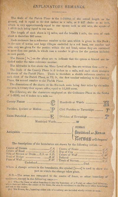
EXPLANATORY REMARKS.
Tho Scale of the Parish Plans is the 1-2500th of the ictual length on the
ground, and is equal to 25'344 inches to a mile, or 3*157 chain - to an in. !.,
which is very approximately equal to one square inch to one acre, the square of
1 *0018 inch being equal to one acre.
Tho length of each sheet is iJ2- miles, and the breadth 1 mile, the area of each
si’eet is therefore 960 acres.
Each enclosure has a reference number to the area which is given in this Book ;
V! ’ll" caso towns and large villages encircled by a red band, one number am1
'troa only are given for the portion within the red band, unless they are contained
in more than one parish, in which case a number is given for the portion included
in each parish.
I he Braces [ <S ] on the plans arc to indicate that the spaces so braced are in¬
cluded under the same reference number.
The Altitudes in feet above the Mean Level of the Sea are written thus 3 / ‘4.
The Scale ol tho County Plans is 6 inches to a mile, and each sheet contains
16 shoots of 1 he Parish Plans. There is therefore a double reference number j,o
o, eh sheet of the Parish Plans, as VI. 9., the first number referring to the County
Plans, the second number to the Parish Plans.
'llu- dimensions of the sheets on the Six-inch scale being four miles by six miles
tho area is twenty-four square miles, equal to 15,360 acres.
Die following are the characters employed on the Ordnance Plans on the Scales
of 1-2500, and 6 inches to a mile 2—
County Names
Parishes, Ancient or Mother 1 £
Extra Parochial
Municipal Wards.
Hundreds or Wards
Civil Parishes or Townships 'X1'
Division of Townships
ROMAN
Ajlti‘iuities - ...<
otSubseqtient
The descriptions of the boundaries are shown by the following initials :•
Centre of Stream C.S.
Centre of Road
Side of Stream or Drain or S.D.
Root of Hedge R.H.
Face of Wall v FJV.
Undefined.......,.,
Centre of Fence
Top of Cop T.C
Centre of Wall _ C.IV.
Defaced ^ ^
Track of Stream V S
Und.
W here a change occurs in the boundaries, the symbol [o—o] is used to show the
part at which the change takes place.
N.B.—The areas are computed to the centre of fence, or other boundasy of
enclosure, except in the following cases :
d.) W he a the fence or other boundary is also the boundarv of a Paris! or oth«i Pivil Dm,; I ,
S the Centre 0f the fence>the area is <0 the Pansn or
Ihe fences, &c., bounding either side of a railway are included wholly within its
acea.
Set display mode to:
![]() Universal Viewer |
Universal Viewer | ![]() Mirador |
Large image | Transcription
Mirador |
Large image | Transcription
Images and transcriptions on this page, including medium image downloads, may be used under the Creative Commons Attribution 4.0 International Licence unless otherwise stated. ![]()
| Ordnance Survey Books of Reference 1855-1882 > Benholm -- North Bute > (91) Explanatory remarks |
|---|
| Permanent URL | https://digital.nls.uk/99224735 |
|---|
| Attribution and copyright: |
|
|---|---|
| Description | These volumes record acreages of fields and land-use information for each parish in Scotland from 1855-1882. They were compiled with the Ordnance Survey 25 inch to the mile maps for that period, which cover all the inhabited parts of Scotland. Numbered land parcels on these maps, listed consecutively within each parish, are included in the relevant parish Book of Reference. |
|---|---|
| Shelfmark | Map.Ref.C18 |
| Additional NLS resources: | |