Ardisier -- Bellie (part of)
(373) Page 59
Download files
Complete book:
Individual page:
Thumbnail gallery: Grid view | List view
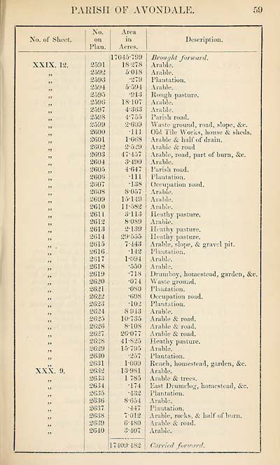
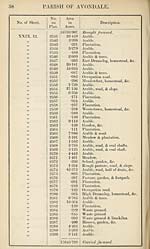
PARISH OF AVONDALE
59
No. of Sheet.
No.
on
Plan.
Area
in
Acres.
Description.
XXIX. 12.
XXX. 9.
2591
2592
2593
2594
2595
2596
2597
2588
2599
2600
2601
2602
2603
2604
2605
2606
2607
2608
2609
2610
2611
2612
2613
2614
2615
2616
2617
2618
2619
2620
2621
2622
2623
2624
2625
2626
2627
2628
2629
2630
2631
2632
2633
2634
2635
2636
2637
2638
2639
2640
17045-799
18-278
5018
■279
5- 594
•913
18-107
4‘383
4'755
2-609
-111
1-668
2- 529
47"457
3- 490
4- 647
•111
•138
8-057
15-149
11-582
3113
8-089
2- 139
29'555
7- 443
•142
1-094
•550
•718
•074
•080
•608
•102
8 943
10-735
8- 108
26-077
41-825
15-795
•257
1-009
13-981
1 785
•174
•432
8-654
•447 !
7-012 !
6- 480
3- 407
Brough t forward.
Arable.
Arable.
Plantation.
Arable.
Hough pasture.
Arable.
Arable.
Parish road.
Waste ground, road, slope, &c.
Old Tile Works, bouse & sheds.
Arable & half of drain.
Arable & road.
Arable, road, part of burn, &c.
Arable.
Parish road.
Plantation.
Occupation road.
Arable.
Arable.
Arable.
Heathy pasture.
Arable.
Heathy pasture.
Heathy pasture.
Arable, slope, & gravel pit.
Plantation.
Arable.
Arable.
Drumboy, homestead, garden, &c.
Waste ground.
Plantation.
Occupation road.
Plantation.
Arable.
Arable & road.
Arable & road.
Arable & road.
Heathy pasture.
Arable.
Plantation.
Rench, homestead, garden, &c.
Arable.
Arable & trees.
East Diumclog, homestead, &c.
Plantation.
Arable.
Plantation.
Arable, rocks, & half of burn.
Arable & road.
Arable.
17409" 482 | Carried for ward.
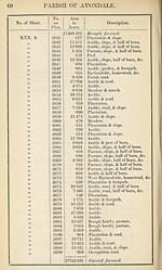
Set display mode to:
![]() Universal Viewer |
Universal Viewer | ![]() Mirador |
Large image | Transcription
Mirador |
Large image | Transcription
Images and transcriptions on this page, including medium image downloads, may be used under the Creative Commons Attribution 4.0 International Licence unless otherwise stated. ![]()
| Ordnance Survey Books of Reference 1855-1882 > Ardisier -- Bellie (part of) > (373) Page 59 |
|---|
| Permanent URL | https://digital.nls.uk/99219523 |
|---|
| Attribution and copyright: |
|
|---|---|
| Description | These volumes record acreages of fields and land-use information for each parish in Scotland from 1855-1882. They were compiled with the Ordnance Survey 25 inch to the mile maps for that period, which cover all the inhabited parts of Scotland. Numbered land parcels on these maps, listed consecutively within each parish, are included in the relevant parish Book of Reference. |
|---|---|
| Shelfmark | Map.Ref.C18 |
| Additional NLS resources: | |