Ardisier -- Bellie (part of)
(336) Page 22
Download files
Complete book:
Individual page:
Thumbnail gallery: Grid view | List view
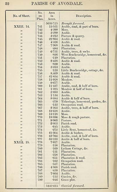
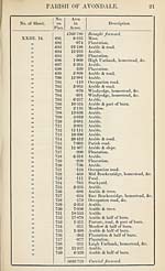
22
PARISH OF AVONDALE.
No. of Sheet.
No.
on
Plan.
Area
in
Acres.
Description.
XXIII. 14.
a
3)
33
33
33
33
33
33
33
33
33
33
33
33
33
33
33
33
33
33
33
33
33
33
33
33
33
33
33
33
33
XXIII. 15.
33
33
33
33
33
33
33
33
33
33
33
33
741
742
743
744
745
746
747
748
749
750
751
752
753
754
755
756
757
758
759
760
761
762
763
764
765
766
767
768
769
770
771
772
773
774
775
776
777
778
779
780
781
782
783
784
785
786
787
788
789
790
5030-725
15-531
4-200
3-299
3- 212
22-864
4- 326
7- 968
•484
6- 751
•826
•119
8- 438
•820
3- 313
•123
8.469
41-854
11-018
9- 677
11-437
1- 325
2- 893
1- 134
8- 084
•370
•133
2 263
44-618
13-118
18-896
9- 903
2- 663
•645
•272
41-364
43-704
33-233
7- 017
•158
•169
•151
■318
•651
•162
•557
4- 868
•430
7-664
•152
•046
5442*415
Brough t for ward.
Arable, road, & part of burn.
Moss.
Arable.
Pasture & quarry.
Arable & road.
Arable.
Arable & road.
Plantation.
Arable, trees, & rocks.
West Brackenridge, homestead, &c.
Plantation.
Arable & road.
Arable.
Arable.
Little Bracken ridge, cottage, &c.
Arable & road.
Arable & road.
Meadow.
Arable.
Arable, road, & half of burn.
Meadow & half of burn.
Arable.
Arable.
Arable & half of burn.
Titherings, homestead, garden, &c.
Occupation road.
Arable, trees, & half of burn.
Arable.
Moss.
Moss & rough pasture.
Pasture.
Parish road.
Arable.
Little Bent, homestead, &c.
Arable & bushes.
Arable, road, & half of burn.
Arable & half of burn.
Arable.
Plantation.
Letham Cottage, &c.
Plantation.
Plantation.
Plantation & road.
Occupation road.
Plantation.
Parish road.
Plantation.
Arable.
Garden, &c.
Grass plot.
Carried forward.
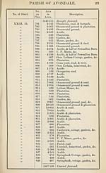
Set display mode to:
![]() Universal Viewer |
Universal Viewer | ![]() Mirador |
Large image | Transcription
Mirador |
Large image | Transcription
Images and transcriptions on this page, including medium image downloads, may be used under the Creative Commons Attribution 4.0 International Licence unless otherwise stated. ![]()
| Ordnance Survey Books of Reference 1855-1882 > Ardisier -- Bellie (part of) > (336) Page 22 |
|---|
| Permanent URL | https://digital.nls.uk/99219079 |
|---|
| Attribution and copyright: |
|
|---|---|
| Description | These volumes record acreages of fields and land-use information for each parish in Scotland from 1855-1882. They were compiled with the Ordnance Survey 25 inch to the mile maps for that period, which cover all the inhabited parts of Scotland. Numbered land parcels on these maps, listed consecutively within each parish, are included in the relevant parish Book of Reference. |
|---|---|
| Shelfmark | Map.Ref.C18 |
| Additional NLS resources: | |