Ardisier -- Bellie (part of)
(321) [Page 7]
Download files
Complete book:
Individual page:
Thumbnail gallery: Grid view | List view
![(321) [Page 7] -](https://deriv.nls.uk/dcn17/9921/99218901.17.jpg)
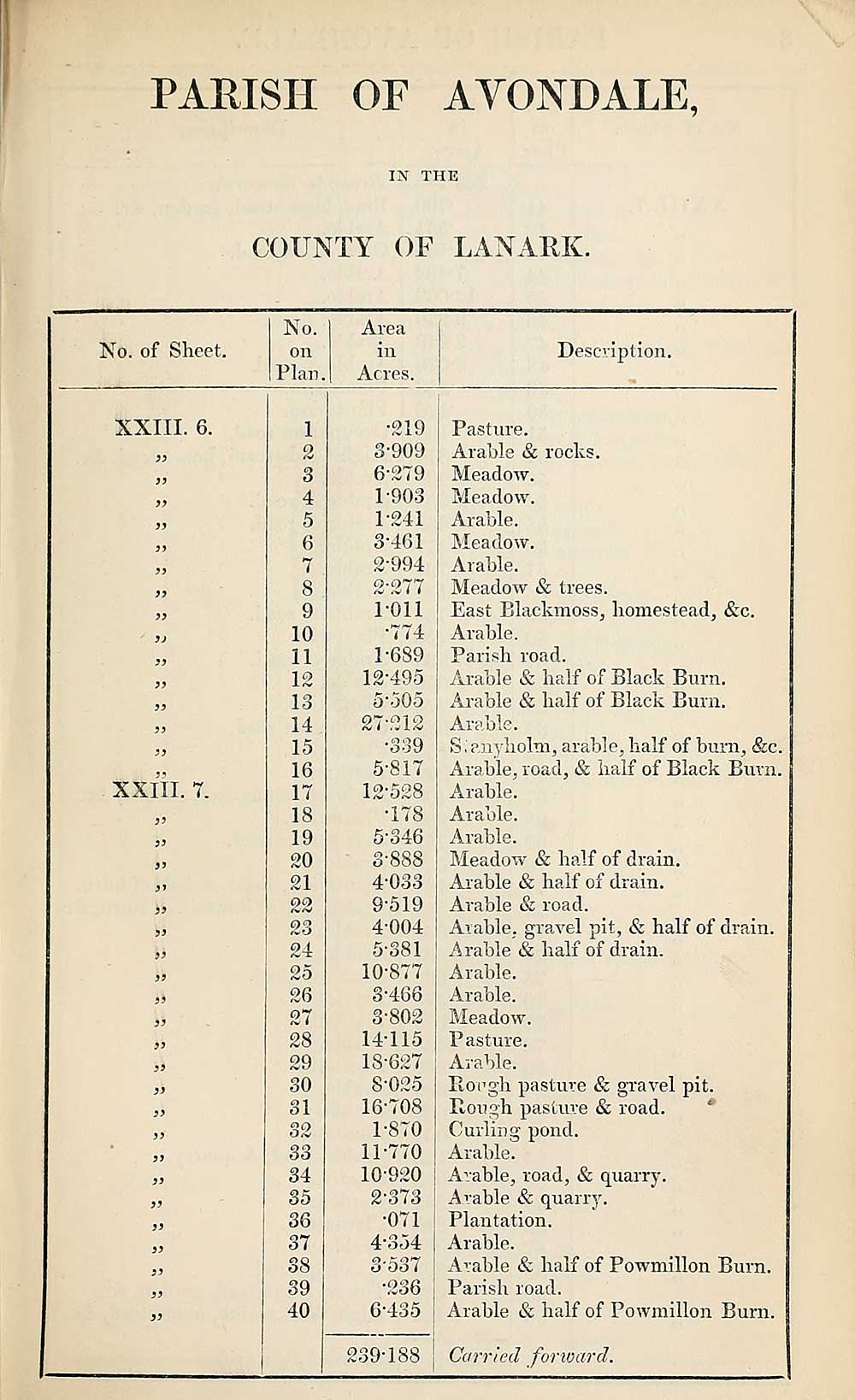
PARISH OF AVONDALE,
IN THE
COUNTY OF LANARK.
No. of Sheet.
No.
on
Plan.
Area
in
Acres.
Description.
XXIII. 6.
})
3)
33
33
33
33
33
33
3J
33
33
33
33
33
XXIII. 7.
33
33
33
33
33
33
33
33
33
33
33
si
33
33
33
33
33
33
33
33
33
33
33
3
4
5
6
7
8
9
10
11
1 o
A rv
13
14
15
16
17
18
19
20
21
24
25
26
27
28
29
30
31
32
33
34
35
36
37
38
39
40
•219
3-909
6-279
1-903
1- 241
3-461
2- 994
2- 277
1-011
•774
1-689
12-495
5*505
27-212
•339
5-817
12*528
•178
5-346
3- 888
4- 033
9-519
4- 004
5- 381
10- 877
3-466
3- 802
14-115
18-627
8-025
16-708
1- 870
11- 770
10-920
2- 373
•071
4- 354
3*537
•236
6- 435
Pasture.
Arable & rocks.
Meadow.
Meadow.
Arable.
Meadow.
Arable.
Meadow & trees.
East Blackmoss, homestead, &c.
Arable.
Parish road.
Arable & half of Black Burn.
Arable & half of Black Burn.
Arable.
S. anyholm, arable, half of burn, &c.
Arable, road, & half of Black Burn.
Arable.
Arable.
Arable.
Meadow & half of drain.
Arable & half of drain.
Arable & road.
Arable, gravel pit, & half of drain.
A rable & half of drain.
Arable.
Arable.
Meadow.
P asture.
Arable.
Bough pasture & gravel pit.
Bough pasture & road.
Curling pond.
Arable.
Arable, road, & quarry.
Arable & quarry.
Plantation.
Arable.
Arable & half of Powmillon Burn.
Parish road.
Arable & half of Powmillon Bum.
oq
9*188 ; Carried forward.
Set display mode to:
![]() Universal Viewer |
Universal Viewer | ![]() Mirador |
Large image | Transcription
Mirador |
Large image | Transcription
Images and transcriptions on this page, including medium image downloads, may be used under the Creative Commons Attribution 4.0 International Licence unless otherwise stated. ![]()
| Ordnance Survey Books of Reference 1855-1882 > Ardisier -- Bellie (part of) > (321) [Page 7] |
|---|
| Permanent URL | https://digital.nls.uk/99218899 |
|---|
| Attribution and copyright: |
|
|---|---|
| Description | These volumes record acreages of fields and land-use information for each parish in Scotland from 1855-1882. They were compiled with the Ordnance Survey 25 inch to the mile maps for that period, which cover all the inhabited parts of Scotland. Numbered land parcels on these maps, listed consecutively within each parish, are included in the relevant parish Book of Reference. |
|---|---|
| Shelfmark | Map.Ref.C18 |
| Additional NLS resources: | |