Abbey -- Ardclach
(623) Page 33
(624) next ›››
Agents for the sale of the Ordnance plans
Download files
Complete book:
Individual page:
Thumbnail gallery: Grid view | List view
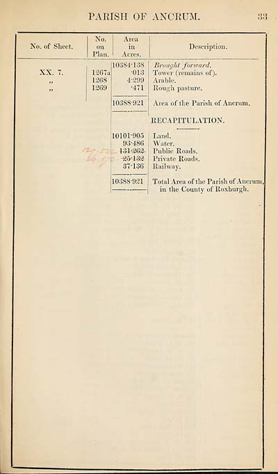
PARISH OF ANCRUM.
oo
oo
No. of Sheet.
No.
on
Plan.
Area
in
Acres.
Description.
XX. 7.
1267a
1268
1269
10384-138
•013
4-299
•471
10388-921
Brought forward.
Tower (remains of).
Arable.
Rough pasture.
Area of the Parish of Ancrum.
RECAPITULATION.
10101-905
93-486
131-262’
25T32
37-136
10388-921
Land.
Water.
Public Roads.
Private Roads.
Railway.
Total Area of the Parish of Ancrum,
in the County of Roxburgh.
oo
oo
No. of Sheet.
No.
on
Plan.
Area
in
Acres.
Description.
XX. 7.
1267a
1268
1269
10384-138
•013
4-299
•471
10388-921
Brought forward.
Tower (remains of).
Arable.
Rough pasture.
Area of the Parish of Ancrum.
RECAPITULATION.
10101-905
93-486
131-262’
25T32
37-136
10388-921
Land.
Water.
Public Roads.
Private Roads.
Railway.
Total Area of the Parish of Ancrum,
in the County of Roxburgh.
Set display mode to:
![]() Universal Viewer |
Universal Viewer | ![]() Mirador |
Large image | Transcription
Mirador |
Large image | Transcription
Images and transcriptions on this page, including medium image downloads, may be used under the Creative Commons Attribution 4.0 International Licence unless otherwise stated. ![]()
| Ordnance Survey Books of Reference 1855-1882 > Abbey -- Ardclach > (623) Page 33 |
|---|
| Permanent URL | https://digital.nls.uk/99214071 |
|---|
| Attribution and copyright: |
|
|---|---|
| Description | These volumes record acreages of fields and land-use information for each parish in Scotland from 1855-1882. They were compiled with the Ordnance Survey 25 inch to the mile maps for that period, which cover all the inhabited parts of Scotland. Numbered land parcels on these maps, listed consecutively within each parish, are included in the relevant parish Book of Reference. |
|---|---|
| Shelfmark | Map.Ref.C18 |
| Additional NLS resources: | |