Abbey -- Ardclach
(74) Page 64
Download files
Complete book:
Individual page:
Thumbnail gallery: Grid view | List view
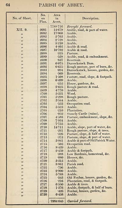
64
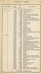
PARISH OF ABBEY
No. of Sheet.
No.
on
Plan, j
XII. 9.
}>
>»
>>
»»
fi
>>
>y
if
a
a
a
a
a
a
a
it
tt
it
tt
if
a
a
it
tt
tt
tt
tt
tt
2681
2682
2683
2684
2685
2686
2687
2688
2689
2690
2691
2692
2693
2694
2695
2696
2697
2698
2699
2700
2701
2702
2703
2704
2705
2706
2707
2708
2709
2710
2711
2712
2713
2714
2715
2716
2717
2718
2719
2720
2721
2722
2723
2724
2725
2726
2727
2728
2729
2730
Area
in
Acres.
7738-716
14-679
17-060
3- 763
2-728
5*210
4- 403
10-792
•335
•538
•837
6-075
6-635
•094
•569
1*508
6- 499
•253
2- 625
4- 770
5- 331
3*298
3*544
•533
5-523
•210
•032
4- 588
7- 934
7- 755
14-711
•261
•326
•373
3- 061
•503
8- 439
2- 459
•388
•080
3- 313
8-861
•796
2-900
5- 768
•543
*216
6- 550
1-376
•426
6*458
Description.
7984-645
Brought forward.
Arable, road, & part of water.
Arable.
Arable.
Arable.
Arable.
Arable & road.
Arable & road.
Pasture.
Arable, road, & embankment.
Reservoir.
Durrockstock Dam.
Rough pasture, part of burn, &c.
Durrockstock, houses, garden, &c.
Reservoir.
Pasture, road, slope, & footpath.
Arable.
House, gardens, &c.
Rough pasture & road.
Arable.
Wood.
Rough pasture.
Arable.
Occupation road.
Arable.
Plantation.
Stanely Castle (ruins).
Pasture, embankment, slope, &c.
Arable.
Arable.
Arable, slope, part of water, &c.
Rough pasture, slope, & trees.
Pasture, slope, & half of water.
Pasture, slope, & part of water.
Arable ik part of Old Patrick Water.
Occupation road.
Arable.
Arable & footpath.
Low Bardrain, homestead, &c.
Houses, &c.
Arable.
Parish road.
Arable.
Arable.
Arable.
Old Foxbar, houses, garden, &c.
Plantation, road, & footpath.
Arable & trees.
Arable, footpath, & half of burn.
Foxbar, houses, garden, &c.
Arable.
Carried forward.
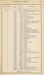
Set display mode to:
![]() Universal Viewer |
Universal Viewer | ![]() Mirador |
Large image | Transcription
Mirador |
Large image | Transcription
Images and transcriptions on this page, including medium image downloads, may be used under the Creative Commons Attribution 4.0 International Licence unless otherwise stated. ![]()
| Ordnance Survey Books of Reference 1855-1882 > Abbey -- Ardclach > (74) Page 64 |
|---|
| Permanent URL | https://digital.nls.uk/99208035 |
|---|
| Attribution and copyright: |
|
|---|---|
| Description | These volumes record acreages of fields and land-use information for each parish in Scotland from 1855-1882. They were compiled with the Ordnance Survey 25 inch to the mile maps for that period, which cover all the inhabited parts of Scotland. Numbered land parcels on these maps, listed consecutively within each parish, are included in the relevant parish Book of Reference. |
|---|---|
| Shelfmark | Map.Ref.C18 |
| Additional NLS resources: | |