Abbey -- Ardclach
(45) Page 35
Download files
Complete book:
Individual page:
Thumbnail gallery: Grid view | List view
PARISH OF ABBEY.
35
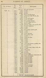
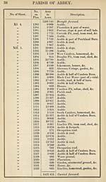
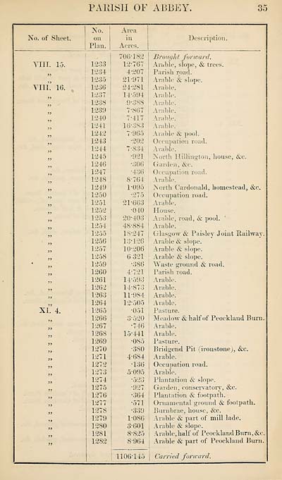
No. of Sheet.
No.
on
Plan.
Area
in
Acres.
vm. 15.
VIII. 10.
JJ
}}
}}
XI. 4.
1203
1234
1255
1230
1257
1238
1239
1240
1241
1242
1243
1244
1245
1246
1247
1248
1249
1250
1251
1252
1253
1254
1255
1256
1257
1258
1259
1260
1261
1262
1263
1264
1265
1266
1267
1268
1269
1270
1271
1272
1273
1274
1275
1276
1277
1278
1279
1280
1281
1282
706-182
12- 767
4-207
21-971
24-281
14-594
9-388
7*867
7-417
16*383
7'965
•202
7- 834
•921
*306
-436
8- 764
1*095
*275
21*663
•040
20-403
48-884
18-247
13- 126
10-206
6 321
•386
4-721
14- 595
14- 873
11- 984
12- 505
■051
3*520
•746
15- 441
■085
•380
4- 684
•136
5- 095
•523
•927
*364
•571
•339
1-086
3-601
8-825
8-964
Description.
Brought forward.
Arable, slope, & trees.
Parish road.
Arable & slope.
Arable.
Arable.
Arable.
Arable.
Arable.
Arable.
Arable & pool.
Occupation road.
Arable.
North Hilling-ton, house, &c.
Garden, &c.
Occupation road.
Arable.
North ('ardonald, homestead, &c.
Occupation road.
Arable.
House.
Arable, road, & pool.
Arable.
Glasgow & Paisley Joint Railway.
Arable & slope.
Arable & slope.
Arable & slope.
Waste ground & road.
Parish road.
Arable.
Arable.
Arable.
Arable.
Pasture.
Meadow & half of Peockland Burn.
Arable.
Arable.
Pasture.
Bridgend Pit (ironstone), &c.
Arable.
Occupation road.
Arable.
Plantation & slope.
Garden, conservatory, &c.
Plantation & footpath.
Ornamental ground & footpath.
Burnbrae, house, &c.
Arable & part of mill lade.
Arable & slope.
Arable,half of Peockland Burn, &c.
Arable & part of Peockland Burn.
1106’145 | Carried forward.
35
No. of Sheet.
No.
on
Plan.
Area
in
Acres.
vm. 15.
VIII. 10.
JJ
}}
}}
XI. 4.
1203
1234
1255
1230
1257
1238
1239
1240
1241
1242
1243
1244
1245
1246
1247
1248
1249
1250
1251
1252
1253
1254
1255
1256
1257
1258
1259
1260
1261
1262
1263
1264
1265
1266
1267
1268
1269
1270
1271
1272
1273
1274
1275
1276
1277
1278
1279
1280
1281
1282
706-182
12- 767
4-207
21-971
24-281
14-594
9-388
7*867
7-417
16*383
7'965
•202
7- 834
•921
*306
-436
8- 764
1*095
*275
21*663
•040
20-403
48-884
18-247
13- 126
10-206
6 321
•386
4-721
14- 595
14- 873
11- 984
12- 505
■051
3*520
•746
15- 441
■085
•380
4- 684
•136
5- 095
•523
•927
*364
•571
•339
1-086
3-601
8-825
8-964
Description.
Brought forward.
Arable, slope, & trees.
Parish road.
Arable & slope.
Arable.
Arable.
Arable.
Arable.
Arable.
Arable.
Arable & pool.
Occupation road.
Arable.
North Hilling-ton, house, &c.
Garden, &c.
Occupation road.
Arable.
North ('ardonald, homestead, &c.
Occupation road.
Arable.
House.
Arable, road, & pool.
Arable.
Glasgow & Paisley Joint Railway.
Arable & slope.
Arable & slope.
Arable & slope.
Waste ground & road.
Parish road.
Arable.
Arable.
Arable.
Arable.
Pasture.
Meadow & half of Peockland Burn.
Arable.
Arable.
Pasture.
Bridgend Pit (ironstone), &c.
Arable.
Occupation road.
Arable.
Plantation & slope.
Garden, conservatory, &c.
Plantation & footpath.
Ornamental ground & footpath.
Burnbrae, house, &c.
Arable & part of mill lade.
Arable & slope.
Arable,half of Peockland Burn, &c.
Arable & part of Peockland Burn.
1106’145 | Carried forward.
Set display mode to:
![]() Universal Viewer |
Universal Viewer | ![]() Mirador |
Large image | Transcription
Mirador |
Large image | Transcription
Images and transcriptions on this page, including medium image downloads, may be used under the Creative Commons Attribution 4.0 International Licence unless otherwise stated. ![]()
| Ordnance Survey Books of Reference 1855-1882 > Abbey -- Ardclach > (45) Page 35 |
|---|
| Permanent URL | https://digital.nls.uk/99207687 |
|---|
| Attribution and copyright: |
|
|---|---|
| Description | These volumes record acreages of fields and land-use information for each parish in Scotland from 1855-1882. They were compiled with the Ordnance Survey 25 inch to the mile maps for that period, which cover all the inhabited parts of Scotland. Numbered land parcels on these maps, listed consecutively within each parish, are included in the relevant parish Book of Reference. |
|---|---|
| Shelfmark | Map.Ref.C18 |
| Additional NLS resources: | |