Abbey -- Ardclach
(41) Page 31
Download files
Complete book:
Individual page:
Thumbnail gallery: Grid view | List view
PARISH OP ABBEY.
31
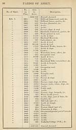
No. of Sheet.
No.
on
Plan.
Area
in
Acres.
Description.
XII. 7
XII? 10.
1053
1054
1055
1056
1057
1058 |
1059
1060
1061 :
1062
1063
1064
1065
1066
1067
1068
1069
1070
1071
1072
1073 i
1074
1075
1076
1077
1078
1079
1080
1081 :
1082
1083
1083a
2517247
3-756
5-215
3- 900
•462
4- 293
•823
1-577
•668
■075
•090
•120
3-665
5- 341
5-960
5-257
3-285
10-803
•432
6 254
3- 577
5-861
621
1-778
4- 365
•171
3-710
8-718
•871
1-806
•301
•306
•016
Brought forward.
Arable.
Arable.
Arable & trees.
Mavisbank, homestead, &c.
Arable.
Plouses, gardens, &c.
Arable & half of Hawkhead Burn.
Low Mavisbank, houses, &c.
Plantation.
West Lodge, &c.
Pasture & half of Hawkhead Burn.
Arable & part of old quarry.
Arable.
Arable.
Arable.
Arable & slope.
Arable & slope.
Plantation.
Arable.
Parish road.
Arable.
Pasture.
Arable.
Arable.
Occupation road.
Arable
Arable.
Arable.
Arable.
Potterhill, homestead, garden, &c.
Arable.
Parish road (part of).
2611-324
RECAPITULATION.
2465-711
76-777
23-385
1-641
34-008
7-105
2" 697
2611-324
Land.
Public roads.
Public Railways.
Private Railways.
Water.
Tidal Water.
Foreshore of tidal water.
Area of kthe Parish of Abbey (ex¬
clusive of Abbey Det.), within
the Parliamentary Boundary of
Paisley.
31
No. of Sheet.
No.
on
Plan.
Area
in
Acres.
Description.
XII. 7
XII? 10.
1053
1054
1055
1056
1057
1058 |
1059
1060
1061 :
1062
1063
1064
1065
1066
1067
1068
1069
1070
1071
1072
1073 i
1074
1075
1076
1077
1078
1079
1080
1081 :
1082
1083
1083a
2517247
3-756
5-215
3- 900
•462
4- 293
•823
1-577
•668
■075
•090
•120
3-665
5- 341
5-960
5-257
3-285
10-803
•432
6 254
3- 577
5-861
621
1-778
4- 365
•171
3-710
8-718
•871
1-806
•301
•306
•016
Brought forward.
Arable.
Arable.
Arable & trees.
Mavisbank, homestead, &c.
Arable.
Plouses, gardens, &c.
Arable & half of Hawkhead Burn.
Low Mavisbank, houses, &c.
Plantation.
West Lodge, &c.
Pasture & half of Hawkhead Burn.
Arable & part of old quarry.
Arable.
Arable.
Arable.
Arable & slope.
Arable & slope.
Plantation.
Arable.
Parish road.
Arable.
Pasture.
Arable.
Arable.
Occupation road.
Arable
Arable.
Arable.
Arable.
Potterhill, homestead, garden, &c.
Arable.
Parish road (part of).
2611-324
RECAPITULATION.
2465-711
76-777
23-385
1-641
34-008
7-105
2" 697
2611-324
Land.
Public roads.
Public Railways.
Private Railways.
Water.
Tidal Water.
Foreshore of tidal water.
Area of kthe Parish of Abbey (ex¬
clusive of Abbey Det.), within
the Parliamentary Boundary of
Paisley.
Set display mode to:
![]() Universal Viewer |
Universal Viewer | ![]() Mirador |
Large image | Transcription
Mirador |
Large image | Transcription
Images and transcriptions on this page, including medium image downloads, may be used under the Creative Commons Attribution 4.0 International Licence unless otherwise stated. ![]()
| Ordnance Survey Books of Reference 1855-1882 > Abbey -- Ardclach > (41) Page 31 |
|---|
| Permanent URL | https://digital.nls.uk/99207639 |
|---|
| Attribution and copyright: |
|
|---|---|
| Description | These volumes record acreages of fields and land-use information for each parish in Scotland from 1855-1882. They were compiled with the Ordnance Survey 25 inch to the mile maps for that period, which cover all the inhabited parts of Scotland. Numbered land parcels on these maps, listed consecutively within each parish, are included in the relevant parish Book of Reference. |
|---|---|
| Shelfmark | Map.Ref.C18 |
| Additional NLS resources: | |