Kilmartin -- Kinclaven
(355) Map - Parish of Kilninver and Kilmelfort
Thumbnail gallery: Grid view | List view
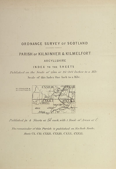
ORDNANCE SORVEY 0 F SCOT LAND
PARISH of KILNINVER & KILMELFQRT
ARGYLLSHIRE
INDEX TO THE S H E E T S
Published on the Scale of 25o« or 25‘344 Inches to a i
Scale of this Index One [nch to a Mile.
KILBRANDON &
KILCHATTAN P?
& cf
Pubfwhed in 4? Sheet#, at 2/6 each, with 1 Booh oTArea# at 1
TheremceiTtder of this Pairishy Ls p ub lishrA on SiffhAi Scalr)
Sheets CX. CXI. CXX1I. CXXJIL CXXX, CXXXL
Set display mode to:
![]() Universal Viewer |
Universal Viewer | ![]() Mirador |
Large image | Transcription
Mirador |
Large image | Transcription
Images and transcriptions on this page, including medium image downloads, may be used under the Creative Commons Attribution 4.0 International Licence unless otherwise stated. ![]()
| Ordnance Survey Books of Reference 1855-1882 > Kilmartin -- Kinclaven > (355) Map - Parish of Kilninver and Kilmelfort |
|---|
| Permanent URL | https://digital.nls.uk/136089297 |
|---|
| Attribution and copyright: |
|
|---|---|
| Description | These volumes record acreages of fields and land-use information for each parish in Scotland from 1855-1882. They were compiled with the Ordnance Survey 25 inch to the mile maps for that period, which cover all the inhabited parts of Scotland. Numbered land parcels on these maps, listed consecutively within each parish, are included in the relevant parish Book of Reference. |
|---|---|
| Shelfmark | Map.Ref.C18 |
| Additional NLS resources: | |