Cullen -- Drumoak
(615) Map - Parish of Dornoch & Do. (detached)
Download files
Complete book:
Individual page:
Thumbnail gallery: Grid view | List view
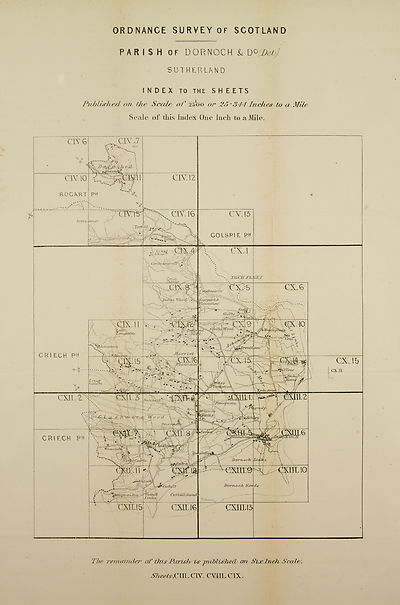
ORDNANCE SURVEY OF SCOTLAND
PARISH of DORNOCH & D°/Ztefc
SUTHERLAND
INDEX TO THE SHEETS
Publushed on th& Scale* of 2500 or 25•344 Inches to a Mile
Scale of this Index One Inch to a Mile.
Trcnis-u lonar
GOLSPIE PH
[pHozt
CartiluLkndreCiltl
USOA'Vti-
iemtcdiaru
SJceZbo
Wood
'‘^tAdhos’ili ch'
'enfharro
a\J6
'iPlantdliori.'
As.ta.iTe
ValcTicgll
WrorLefpiatn
Vversjcdh
lavoci
d) crrrvo oh*.. Hr,
'‘Vuthdil / CicfhfUl/Sccncl
Xvilkd /_
jEf0gy[towrifri
GSTLIG
CX. 15
CXH.
Thw -nrmatnder of thisTarishyies piMUdhecU orb StoeTneh ScaW.
SheelsdClXL dST. CVJiL CIX.
Set display mode to:
![]() Universal Viewer |
Universal Viewer | ![]() Mirador |
Large image | Transcription
Mirador |
Large image | Transcription
Images and transcriptions on this page, including medium image downloads, may be used under the Creative Commons Attribution 4.0 International Licence unless otherwise stated. ![]()
| Ordnance Survey Books of Reference 1855-1882 > Cullen -- Drumoak > (615) Map - Parish of Dornoch & Do. (detached) |
|---|
| Permanent URL | https://digital.nls.uk/130594722 |
|---|
| Attribution and copyright: |
|
|---|---|
| Description | These volumes record acreages of fields and land-use information for each parish in Scotland from 1855-1882. They were compiled with the Ordnance Survey 25 inch to the mile maps for that period, which cover all the inhabited parts of Scotland. Numbered land parcels on these maps, listed consecutively within each parish, are included in the relevant parish Book of Reference. |
|---|---|
| Shelfmark | Map.Ref.C18 |
| Additional NLS resources: | |