Chapel of Garioch -- Cruden
(653) Map - Parish of Cross, Orkney & Shetland (Orkney)
Thumbnail gallery: Grid view | List view
/Orkney)
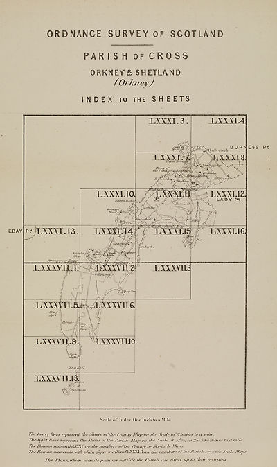
INDEX to the SH EETS
T/w Jmry represent the Sheets of the Countr Map on the Seale „fti inches to a mile.
The light lines represent the Sheets of the Parish Map. on the Scale of zthro, or 26 344 inches to a mile.
-L he Hot ruin nunieraLkSSCk\ nee the numbers of the ('aunty or Six-in eh JSlaps.
TheMoinan TUimemls with plain fitjures affixedXSS3SS\.are the numbers of the Parish or jfli'oo Scale Slaps.
The Plans, whiih intitule portions outside dm Parish, are /Wed' up to their margins.
RH
Set display mode to:
![]() Universal Viewer |
Universal Viewer | ![]() Mirador |
Large image | Transcription
Mirador |
Large image | Transcription
Images and transcriptions on this page, including medium image downloads, may be used under the Creative Commons Attribution 4.0 International Licence unless otherwise stated. ![]()
| Ordnance Survey Books of Reference 1855-1882 > Chapel of Garioch -- Cruden > (653) Map - Parish of Cross, Orkney & Shetland (Orkney) |
|---|
| Permanent URL | https://digital.nls.uk/130385367 |
|---|
| Attribution and copyright: |
|
|---|---|
| Description | These volumes record acreages of fields and land-use information for each parish in Scotland from 1855-1882. They were compiled with the Ordnance Survey 25 inch to the mile maps for that period, which cover all the inhabited parts of Scotland. Numbered land parcels on these maps, listed consecutively within each parish, are included in the relevant parish Book of Reference. |
|---|---|
| Shelfmark | Map.Ref.C18 |
| Additional NLS resources: | |