Hamilton manuscripts
(183) Page iii
Download files
Complete book:
Individual page:
Thumbnail gallery: Grid view | List view

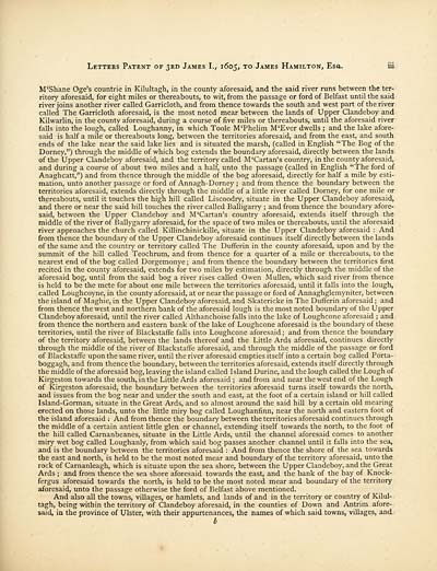
Letters Patent of 3rd James I., 1605, to James Hamilton, Esa. iii
M'Shane Oge's countrie in Kilultagh, in the county aforesaid, and the said river runs between the ter-
ritory aforesaid, for eight miles or thereabouts, to wit, from the passage or ford of Belfast until the said
river joins another river called Garricloth, and from thence towards the south and west part of the river
called The Garricloth aforesaid, is the most noted mear between the lands of Upper Clandeboy and
Kilwarlin, in the county aforesaid, during a course of five miles or thereabouts, until the aforesaid river
falls into the lough, called Loughanny, in which Toole M'Phelim M'Ever dwells ; and the lake afore-
said is half a mile or thereabouts long, between the territories aforesaid, and from the east, and south
ends of the lake near the said lake lies and is situated the marsh, (called in English "The Bog of the
Dorney,") through the middle of which bog extends the boundary aforesaid, directly between the lands
of the Upper Clandeboy aforesaid, and the territory called M'Cartan's country, in the county aforesaid,
and during a course of about two miles and a half, unto the passage (called in English "The ford of
Anaghcatt,") and from thence through the middle of the bog aforesaid, directly for half a mile by esti-
mation, unto another passage or ford of Annagh-Dorney ; and from thence the boundary between the
territories aforesaid, extends directly through the middle of a little river called Dorney, for one mile or
thereabouts, until it touches the high hill called Liscoodry, situate in the Upper Clandeboy aforesaid,
and there or near the said hill touches the river called Balligarry ; and from thence the boundary afore-
said, between the Upper Clandeboy and M'Cartan's country aforesaid, extends itself through the
middle of the river of Ballygarry aforesaid, for the space of two miles or thereabouts, until the aforesaid
river approaches the church called Killinchinickille, situate in the Upper Clandeboy aforesaid : And
from thence the boundary of the Upper Clandeboy aforesaid continues itself directly between the lands
of the same and the country or territory called The Dufferin in the county aforesaid, upon and by the
summit of the hill called Teochrum, and from thence for a quarter of a mile or thereabouts, to the
nearest end of the bog called Dorgemonye; and from thence the boundary between the territories first
recited in the county aforesaid, extends for two miles by estimation, directly through the middle of the
aforesaid bog, until from the said bog a river rises called Owen Mullen, which said river from thence
is held to be the mete for about one mile between the territories aforesaid, until it falls into the lough,
called Loughcoyne, in the county aforesaid, at or near the passage or ford of Annaghglemyniter, between
the island of Maghie, in the Upper Clandeboy aforesaid, and Skatericke in The Dufferin aforesaid ; and
from thence the west and northern bank of the aforesaid lough is the most noted boundary of the Upper
Clandeboy aforesaid, until the river called Althanchoise falls into the lake of Loughcone aforesaid ; and
from thence the northern and eastern bank of the lake of Loughcone aforesaid is the boundary of these
territories, until the river of Blackstaffe falls into Loughcone aforesaid ; and from thence the boundary
of the territory aforesaid, between the lands thereof and the Little Ards aforesaid, continues directly
through the middle of the river of Blackstaffe aforesaid, and through the middle of the passage or ford
of Blackstaffe upon the same river, until the river aforesaid empties itself into a certain bog called Porta-
boggagh, and from thence the boundary, between the territories aforesaid, extends itself directly through
the middle of the aforesaid bog, leaving the island called Island Durine, and the lough called the Lough of
Kirgeston towards the south, in the Little Ards aforesaid ; and from and near the west end of the Lough
of Kirgeston aforesaid, the boundary between the territories aforesaid turns itself towards the north,
and issues from the bog near and under the south and east, at the foot of a certain island or hill called
Island-Gorman, situate in the Great Ards, and so almost around the said hill by a certain old mearing
erected on those lands, unto the little miry bog called Loughanfinn, near the north and eastern foot of
the island aforesaid ; And from thence the boundary between the territories aforesaid continues through
the middle of a certain antient little glen or channel, extending itself towards the north, to the foot of
the hill called Carnanbeanes, situate in the Little Ards, until the channel aforesaid comes to another
miry wet bog called Loughanly, from which said bog passes another channel until it falls into the sea,
and is the boundary between the territories aforesaid : And from thence the shore of the sea towards
the east and north, is held to be the most noted mear and boundary of the territory aforesaid, unto the
rock of Carnanleagh, which is situate upon the sea shore, between the Upper Clandeboy, and the Great
Ards ; and from thence the sea shore aforesaid towards the east, and the bank of the bay of Knock-
fergus aforesaid towards the north, is held to be the most noted mear and boundary of the territory
aforesaid, unto the passage otherwise the ford of Belfast above mentioned.
And also all the towns, villages, or hamlets, and lands of and in the territory or country of Kilul-
tagh, being within the territory of Clandeboy aforesaid, in the counties of Down and Antrim afore-
said, in the province of Ulster, with their appurtenances, the names of which said towns, villages, and
b
Set display mode to:
![]() Universal Viewer |
Universal Viewer | ![]() Mirador |
Large image | Transcription
Mirador |
Large image | Transcription
Images and transcriptions on this page, including medium image downloads, may be used under the Creative Commons Attribution 4.0 International Licence unless otherwise stated. ![]()
| Histories of Scottish families > Hamilton manuscripts > (183) Page iii |
|---|
| Permanent URL | https://digital.nls.uk/95559661 |
|---|
| Description | A selection of almost 400 printed items relating to the history of Scottish families, mostly dating from the 19th and early 20th centuries. Includes memoirs, genealogies and clan histories, with a few produced by emigrant families. The earliest family history goes back to AD 916. |
|---|

