Topographical, statistical, and historical gazetteer of Scotland > Volume 2
(615) Page 597
Download files
Complete book:
Individual page:
Thumbnail gallery: Grid view | List view

RON
597
RON
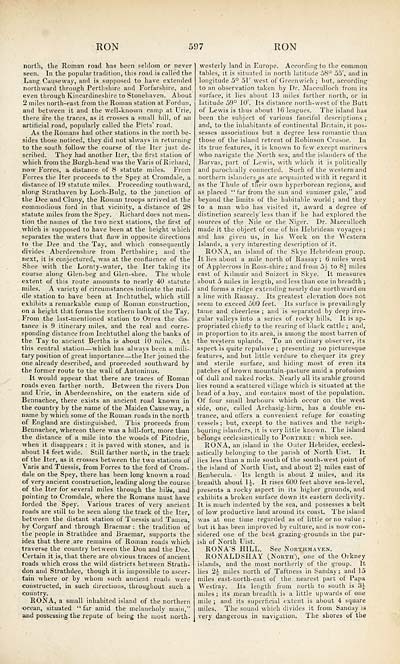
north, the Roman roail has been seldom or never
seen. In the popular tradition, this road is called the
Lang Causeway, and is supposed to have extended
northward through Perthshire and Forfarshire, and
even through Kincardineshire to Stonehaven. About
2 miles north-east from the Roman station at Fordun,
and between it and the well-known camp at Urie,
there are the traces, as it crosses a small hill, of an
artilieial road, popularly called the Picts' road.
As the Romans had other stations in the north be-
sides those noticed, they did not always in returning
to the south follow the course of the Iter just de-
scribed. They had another Iter,, the first station of
which from the Burgh-head was the Varis of Richard,
now Forres, a distance of 8 statute miles. From
Forres the Iter proceeds to the Spey at Cromdale, a
distance of 19 statute miles. Proceeding southward,
along Strathaven by Loch-Bulg, to the junction of
the Dee and Cluny, the Roman troops arrived at the
commodious ford in that vicinity, a distance of 28
statute miles from the Spey. Richard does not men-
tion the names of the two next stations, the first of
which is supposed to have been at the height which
separates the waters that flow in opposite directions
to the Dee and the Tay, and which consequently
divides Aberdeenshire from Perthshire; and the
next, it is conjectured, was at the confluence of the
Shee with the Lornty-water, the Iter taking its
course along Glen-beg and Glen-shee. The whole
extent of this route amounts to nearly 40 statute
miles. A variety of circumstances indicate the mid-
dle station to have been at Inchtuthel, which still
exhibits a remarkable camp of Roman construction,
on a height that forms the northern bank of the Tay.
From the last-mentioned station to Orrea the dis-
tance is 9 itinerary miles, and the real and corre-
sponding distance from Inchtuthel along the banks of
the Tay to ancient Bertha is about 10 miles. At
this central station — which has always been a mili-
tary position of great importance — the Iter joined the
one already described, and proceeded southward by
the former route to the wall of Antoninus.
It would appear that there are traces of Roman
roads even farther north. Between the rivers Don
and Urie, in Aberdeenshire, on the eastern side of
Bennachee, there exists an ancient road known in
the country by the name of the Maiden Causeway, a
name by which some of the Roman roads in the north
of England are distinguished. This proceeds from
Bennachee, whereon there was a hill-fort, more than
the distance of a mile into the woods of Pitodrie,
when it disappears : it is paved with stones, and is
about 14 feet wide. Still farther north, in the track
of the Iter, as it crosses between the two stations of
Varis and Tuessis, from Forres to the ford of Crom-
dale on the Spey, there has been long known a road
of very ancient construction, leading along the course
of the Iter for several miles through the hilis, and
pointing to Cromdale, where the Romans must have
forded the Spey. Various traces of very ancient
roads are still to be seen along the track of the Iter,
between the distant station of Tuessis and Tainea,
by Corgarf and through Braemar : the tradition of'
the people in Strathdee and Braemar, supports the
idea that there are remains of Roman roads which
traverse the country between the Don and the Dee.
Certain it is, that there are obvious traces of ancient
roads which cross the wild districts between Strath-
don and Strathdee, though it is impossible to ascer-
tain where or by whom such ancient roads were
constructed, in such directions, throughout such a
country.
RONA, a small inhabited island of the northern
ocean, situated "far amid the melancholv main,"
and possessing the repute of being the most north-
westerly land in Europe. According to the common
tables, it is situated in north latitude 58° 55', and in
longitude 5° 51' west of Greenwich; but, according
to an observation taken by Dr. Macculloch from its
surface, it lies about 13 miles farther north, or ia
latitude 59° 10'. Its distance north-west of the Butt
of Lewis is thus about 16 leagues. The island han
been the subject of various fanciful descriptions ;
and, to the inhabitants of continental Britain, it pos-
sesses associations but a degree less romantic than
those of the island retreat of Robinson Crusoe. In
its true features, it is known to few except mariners
who navigate the North sea, and the islanders of the
Barvas, part of Lewis, with which it is politically
and parochially connected. Such of the western and
northern islanders as are acquainted with it regard it
as the Thule of their own hyperborean regions, and
as placed " tar from the sun and summer gale," and
beyond the limits of the habitable world ; and they
to a man who has visited it, award a degree of
distinction scarcely less than if he had explored the
sources of the Nile or the Niger. Dr. Macculloch
made it the object of one of his Hebridean voyages;
and has given us, in his Work on the Western
Islands, a very interesting description of it.
RONA, an island of the Skye Hebridean group.
It lies about a mile north of Raasay; 6 miles west
of Applecross in Ross-shire; and from 5i to 8J miles
east of Kilmuir and Snizort in Skye. It measures
about 5 miles in length, and less than one in breadth ;
and forms a ridge extending nearly due northward on
a line with Raasay. . Its greatest elevation does not
seem to exceed 500 feet. Its surface is prevailingly
tame and cheerless ; and is separated by deep irre-
gular valleys into a series of rocky hills. It is ap-
propriated chiefly to the rearing of black cattle ; and,
in proportion to its-area, is among the most barren of
the western uplands. To an ordinary observer, its
aspect is quite repulsive ; presenting no picturesque
features, and but little verdure to chequer its grey
and sterile surface, and hiding most of even its
patches of brown mountain-pasture amid a profusion
of dull and naked rocks.. Nearly all its arable ground
lies round a scattered village which is situated at the
head of a. bay, and contains most of the population.
Of four small harbours which occur on the west
side, one, called Archasig-hirm, has a double en-
trance, and offers a convenient refuge for coasting
vessels; but, except to the natives and the neigh-
bouring islanders, it is very little known. The island
belongs ecclesiastically to Portree : which see.
RONA, an island in the Outer Hebrides, ecclesi-
astically belonging to the parish of North Uist. It
lies less than a mile south of the south-west point of
the island of North Uist, and about 2.V miles east of
Benbecula. ■ Its length is about 2 miles, and its
breadth about 1J. It rises 600 feet above sea-level,
presents a rocky aspect in its higher grounds, and
exhibits a broken surface down its eastern declivity.
It is much indented by the sea, and possesses a belt
of low productive land around its coast. The island
was at one time regarded as of little or no value ;
but it has been improved by culture, and is now con-
sidered one of the best grazing-grounds in the par-
ish of North Uist.
RONA'S HILL. See Northmaven.
RONALDSHAY (North), one of the Orkney
islands, and the most northerly of the group. It
lies 2J- miles north of Taftness in Sanday ; and 15
miles east-north-east of the nearest part of Papa
West'ray. Its length from north to south is 3J-
miles ; its mean breadth is a little upwards of one
mile ; and its superficial extent is about 4 square
miles. The sound which divides it from Sanday is
very dangerous in navigation. The shores of the
Set display mode to: Large image | Transcription
Images and transcriptions on this page, including medium image downloads, may be used under the Creative Commons Attribution 4.0 International Licence unless otherwise stated. ![]()
| Gazetteers of Scotland, 1803-1901 > Topographical, statistical, and historical gazetteer of Scotland > Volume 2 > (615) Page 597 |
|---|
| Permanent URL | https://digital.nls.uk/97501343 |
|---|
| Description | Volume second. I-Z. |
|---|---|
| Attribution and copyright: |
|

