Topographical, statistical, and historical gazetteer of Scotland > Volume 2
(323) Page 309
Download files
Complete book:
Individual page:
Thumbnail gallery: Grid view | List view

LOR
309
LOT
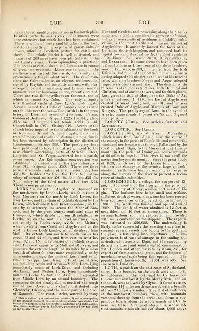
ills' on the red sandstone formation in tlie north plain.
In other parts the soil is clay. The mosses were
Oiree extensive, but much land lias heen reclaimed.
There is a line of benty sand-hillocks on the east;
and to the north a fine expanse of grassy links or
downs, affording excellent pasture for cattle and
sheep. The whole district is well-cultivated, and
upwards of 200 acres have heen planted within the
last twenty years. Trench-ploughing is practised.
The breeds of cattle, sheep, and horses are in course
of great improvement. Limestone is found in the
north-eastern part of the parish, but sienite and
greenstone are the prevalent rock. The chief man-
sions are Cairness-house, an elegant residence, de-
signed by Playfair, and tastefully adorned with plea-
sure-grounds and plantations, and Crimond-mogate
mansion, another handsome edifice, recently erected.
There are two fishing-villages on the coast, one of
which is named St. Colm. The only antiquity
is a Druidical circle at Newark, Crimond-mogate.
A castle mimed the Castle of Lonmay once existed
on the links near the sea. — The parisli is in. the pres-
bytery of Deer, and synod of Aberdeen. Patron,
Gordon of Beithlaw. Stipend £225 13s. 3d. ; glebe
£18 15s. Unappropriated tenuis £224 7s. 4d.
Church built in 1787. Sittings G49. Access to the
church being impeded to the inhabitants of the lands
of Kinninmonth and Crimond-mogate, by a large
tract of mossy bad roads and distance, a new church
has been erected by subscription in the district of
Kinninmonth : sittings 3fi0. The presbytery have
been petitioned to have the district annexed to the
new church, — including parts of Strichen, Deer,
Longside, and St. Fergus, — erected into a parish,
quoad sacra. An Episcopalian congregation was
established here shortly after the Revolution : sit-
tings 342. Stipend about £50. There are three
parochial schools r salary of first master £28 ; fees
£23 8s., besides £25 from the Dick bequest : —
salary of second master £21 6s. 3d. ; fees £21 Gs.
3d.: — salary of the third master £10; fees £15.
There is one private school.
LORN,* a district in Argyleshire; bounded on
ithe north-west by Linnhe-Loch, which divides it
from Morvern ; on the north by Loch-Leven, the
river Leven, and the chain of lochlets drained by the
Leven, which divide it from Inverness-shire ; on the
cast by an arbitrary line across the Moor of Ran-
noch, and by the great central southward ridge of
Grampians, which divide it from Breadalbane in
Perthshire; on the south by brief arbitrary lines,
and chiefly by Lochs Awe, Avich, and Melfort,
which divide it from Cowal and Argyle ; and on the
west by Lower Loch-Linnhe, which divides it from
Mull. Its extent from north to south varies be-
tween 33 and 22 miles, and from, east to west be-
tween 32 and 15. The district of it which extends
along the coast opposite to Mull and Morvern, and
possesses the extreme length of 33 miles by a mean
breadth of about 9, bears more emphatically, or by
more uniform usage, the name of Lorn ; and is di-
vided into Upper Lorn, lying north of Locli-Etive,
and including Appin and Aiids, — Middle Lorn, lying
immediately south of Loch-Etive, and including
Muckairn, — and Nether Lorn, lying immediately
north of Lochs Melfort and Avich, but separated
from Middle Lorn by no natural boundary. The
remaining district nearly all lies north of the north
end of Loch-Awe, and is chiefly distributed into
Glenorchy, Glencoe, and the minor part of the Moor
ot Rannoch. The coast-district, watered by many
* This is evidently a modern contraction, if not a corruption,
of the ancient name of this interesting district, — a district so
frequently alluded to by the Scottish historian and antiquarian.
The Gaelic orthography is Labhrin, pronounced by the Gael
**1 the district Laurin.
lakes and rivulets, and possessing along their banks
much arable land, a considerable aggregate of wood,
and extensive results of assiduous and skilful culti-
vation, is the most fertile and pleasant, district of
Argyleshire. It anciently formed the focus of the
Dalriadan Scottish kingdom, and possessed both its
capital town and its royal castle, the chief residence
of its kings. See Beregorium, Dunstaftnace,
and Dai.riads. Its name seems to have been given
it from Labhrin or Loam, one of the three brothers,
sons of Ere, who, in 503, immigrated from the Irish
Dalriada, and founded the Scottish monarchy; Loam
having adopted this district as the seat of his nascent
tribe, while his brothers Fergus and Angus adopted
respectively Kintyre and Islay. The district is rife
in remains of religious structures, both Druidical and
Christian, and of ancient towers, and fortified places,
horn gives the title of Marquis to the Duke of Ar-
gyle's eldest son. In 1470, one Earl of Argyle was
created Baron of Lorn; and, in 1701, another was
created Duke of Argyle, and Marquis of Lorn and
Kintyre. The presbytery of Lorn, in the synod of
Argyle, comprehends 7 quoad civilia and 3 quoad
sacra parishes.
LORNTY (The). See articles Clunib and
Lethendy.
LOSKENTTR. See Harris.
LOSSIE (The), a small river in Morayshire,
which issues from Loch-Lossie, near the centre of
the county, in the parish of Edenkiflie, and runs north-
wards and north-eastwards through Dallas, and by the
royal burgh of Elgin, to the Moray frith, at Lossie-
mouth, in the parish of Drainy, — a course upwards
of 26 miles in length. This river is too small for
navigation beyond its mouth. Since the great floods
of 1829, which swelled the Lossie to inundation,
with serious damage to the vicinity, large embank-
ments of earth have been raised at great expense
along the margins of the river to prevent a recur-
rence of similar calamities.
LOSSIEMOUTH, a village, the sea-port of El-
gin, at the mouth of the Lossie, in the parish of
Drainy, county of Moray, 5 miles north-east of El-
gin. The harbour here being small and without
sufficient depth of water, a new one has been erected
by a company incorporated by act of parliament in
1834. The work was finished and opened end of
1829. The depth of water obtained is 12 feet at
neap-tides, and 16 feet at spring-tides. There is
an inner harbour, completely protected, and provided
with many conveniences for shipping. The expense
was estimated at £20,000. The undertaking is
likely to be successful ; the coasting trade lias in-
creased ; several vessels now belong to the port, and
the place is fast rising into importance. The im-
provement is of vast advantage to the trading and
agricultural interests of Elgin, and the surrounding
district ; a direct and uninterrupted communication
with London and other markets by steam, &e., for
exports of farm-stock and grain, and for imports of
merchandise and coals being thus opened up. The
population of Lossiemouth, in 1S31, was 535. See
also article Dkainv.
LOTH, a parish on the east coast of Sutherland-
shire. It is bounded on the north-west and north
by Kildonan ; on the north-east by Caithness; on
the east and south-east by the Moray frith ; and on
the south-west and west by Clyne. It forms a stripe,
extending LL} miles north-eastward, with a breadth
of from 2 to nearly 4 miles. The Ord of Caithness,
at the north-east boundary, rises, with mountain
vastness, sheer up from the ocean, and forms a stu-
pendous barrier along the whole march with Caith-
ness : see Ord. A range of steep hills, wdiose lof-
tiest summits attain altitudes of about 1,900 above
Set display mode to: Large image | Transcription
Images and transcriptions on this page, including medium image downloads, may be used under the Creative Commons Attribution 4.0 International Licence unless otherwise stated. ![]()
| Gazetteers of Scotland, 1803-1901 > Topographical, statistical, and historical gazetteer of Scotland > Volume 2 > (323) Page 309 |
|---|
| Permanent URL | https://digital.nls.uk/97497839 |
|---|
| Description | Volume second. I-Z. |
|---|---|
| Attribution and copyright: |
|

