Download files
Complete book:
Individual page:
Thumbnail gallery: Grid view | List view

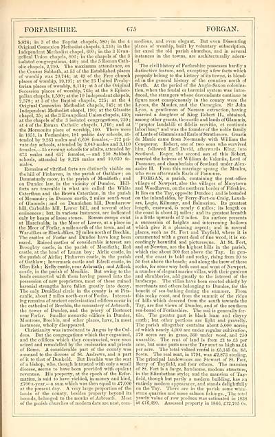
FORFARSHIRE.
G75
FORGAN.
5,824; ill 3 of the Baptist chapels, 580; in the 4
Original Connexion Methodist chapels, 1,330; in the
Independent Methodist chapel, 600; in the 3 Evan-
gelical Union chapels, 806 ; in the chapels of the 3
isolated congregations, 440; and the 5 Roman Cath-
olic chapels, 2,290. The maximum attendance, on
the Census Sabbath, at 53 of the Established places
of worship was 20,744; at 49 of the Free church
places of worship, 19,197; at the 23 United Presby-
terian places of worship, 8,114; at 5 of the Original
Secession places of worship, 765; at the 8 Episco-
palian chapels, 1,590; at the 10 Independent chapels,
2,578; at 3 of the Baptist chapels, 225; at the 4
Original Connexion Methodist chapels, 745; at the
Independent Methodist chapel, 190; at the Glassite
chapel, 35; at the 3 Evangelical Union chapels, 440;
at the chapels of the 3 isolated congregations, 230 ;
at 4 of the Roman Catholic chapels, 1,246; and at
the Mormonite place of worship, 100. There were
in 1851, in Forfarshire, 181 public day schools, at-
tended by 9,263 males and 6,698 females,— 122 pri-
vate day schools, attended by 3,049 males and 3,110
females, — 35 evening schools for adults, attended by
673 males and 657 females, — and 230 Sabbath
schools, attended by 8,128 males and 10,030 fe-
males.
Remains of vitrified forts are distinctly visible on
the hill of Finhaven, in the parish of Oathlaw; on
Drumsturdy moor, in the parish of Monifieth ; and
on Dundee law, in the vicinity of Dundee. Hill-
forts are traceable in what are called the White
Caterthun and the Brown Caterthun, in the parish
of Menmuir; in Denoon castle, 2 miles south-west
of Glammis ; and on Dunnichen hill, Dumbarrow
hill, Carbuddo hill, Lower hill, and several other
eminences ; but, in various instances, are indicated
only by heaps of loose stones. Roman camps exist
at Harefaulds, in the Moor of Lower, at a place in
the Moor of Forfar, a mile north of the town, and at
War-dikes or Black-dikes, 2 J miles north of Brechin.
The castles of Forfar and Dundee have long been
razed. Ruined castles of considerable interest are
Broughtj' castle, in the parish of Monifieth ; Red
castle, at the head of Lunan bay ; Airlie castle, in
the parish of Airlie; Finhaven castle, in the parish
of Oathlaw ; Invermark castle and Edzell castle, in
Glen Esk ; Kelly castle, near Arbroath ; and Affleck
castle, in the parish of Monikie. But owing to the
lands connected rath them having passed into the
possession of new proprietors, most of these ruined
baronial strengths have fallen greatly into decay.
The only Druidical circle in the county is at Pits-
canlie, about 2 miles north-east of Forfar. Interest-
ing remains of ancient ecclesiastical edifices occur in
the cathedral of Brechin, the monastery of Arbroath,
the tower of Dundee, and the priory of Restenet
near Forfar. Smaller monastic edifices in Dundee,
Montrose, Brechin, and other places, have, in most
instances, wholly disappeared.
Christianity was introduced to Angus by the Oil-
dees. But the congregations which they organized,
and the edifices which they constructed, were soon
seized and remodelled by the emissaries and priests
of Rome. A considerable part of the county was
annexed to the diocese of St. Andrews, and a part
of it to that of Dunkeld. But Brechin was the seat
of a bishop, who, though intrusted with only a small
diocese, seems to have been provided with opulent
revenues. His property, at the epoch of the Refor-
mation, is said to have yielded, in money and kind,
£700a-year, — a sum which was then equal to £7,000
at the present day. A very large proportion of the
lands of the county, besides property beyond its
bounds, belonged to the monks of Arbroath. Most
of the parish churches of modem date are neat, com-
modious, and even elegant. But even Dissenting
places of worship, built by voluntary subscription,
far excel the old parish churches, and in several
instances in the towns, are architecturally adorn-
ed.
The civil history of Forfarshire possesses hardly a
distinctive feature, and, excepting a few facts which
properly belong to the history of its towns, is blend-
ed in the general history of the counties north of
Forth. At the period of the Anglo-Saxon coloniza-
tion, when the feudal or baronial system was intro-
duced, the strangers whose descendants continue to
figure most conspicuously in the county were the
Lyons, the Maules, and the Carnegies. Sir John
Lyon, a gentleman of Norman extraction, having
married a daughter of King Robert II., obtained,
among other grants, the castle and lands of Glammis,
" propter laudabili et fidelia servitio, et contimiis
laboribus;" and was the founder of the noble family
of Lords of GlammisandEarlsofStrathmore. Guarin
de Maule came from Normandy with William the
Conqueror. Robert, one of two sons who survived
him, followed Earl David, afterwards King, into
Scotland. Roger, the second son of this Robert,
married the heiress of William de Valoniis, Lord of
Panmure, and chamberlain of Scotland under Alex-
ander II. From this marriage sprang the Maules,
who were afterwards Earls of Panmure.
FORGAN, a parish, containing the post-office
village of Newport, also the villages of Marytown
and Woodhaven, on the northern border of Fifeshire.
It lies on the Tay, opposite Dundee ; and is bounded
on the inland sides, by Ferry-Port-on-Craig, Leuch-
ars, Logie, Kilmany, and Balmerino. Its greatest
length, eastward, is nearly 6 miles; its length on
the coast is about 3J miles ; and its greatest breadth
is a little upwards of 2 miles. Its surface presents
a succession of heights and intervening hollows
which give it a pleasing aspect; and in several
places, such as St. Fort and Tayfield, where it is
ornamented with a great deal of fine wood, it is ex-
ceedingly beautiful and picturesque. At St. Fort,
and at Newton, are the highest hills in the parish,
which rise about 300 feet above the Tay. In gen-
eral, the coast is bold and rocky, rising from 30 to
50 feet above the beach ; and along the brow of these
rocks, for some way both east and west of Newport,
a number of elegant marine villas, with their gardens
and shrubberies, add greatly to the interest of the
landscape. The villas have been erected chiefly by
merchants and others belonging to Dundee, for the
benefit of sea-bathing during the summer. From
this rocky coast, and from the summit of the ridge
of hills which descend from the south towards the
Tay, are fine views of Dundee, and of the southern
sea-board of Forfarshire. The soil is generally fer-
tile. The greater part is black loam and clayey
earth ; but other portions are light and gravelly.
The parish altogether contains about 5,000 acres;
of which nearly 4,000 are under regular cultivation,
370 acres are in grass, 360 under wood, and 250
unarable. The rent of land is from £1 to £3 per
acre, but some parts near the Tay rent as high as £4
per acre. The total valued rental is £5.145 6s. 8d.
Scots. The real rent, in 1794, was £2,873 sterling.
The principal landowners are Stewart of St. Fort,
Berry of Tayfield, and four others. The mansion
of St. Fort is a large, handsome, modern structure,
in the Elizabethan style; aud the mansion of Tay-
field, though but partly a modern building, has an
entirely modern appearance, and stands delightfully
on the Taj'. There are in the parish some whin-
stone quarries and some salmon fishings. .The total
yearly value of raw produce was estimated in 1838
at £16,490. Assessed property in 1866, £12,705 0s.
Set display mode to: Large image | Transcription
Images and transcriptions on this page, including medium image downloads, may be used under the Creative Commons Attribution 4.0 International Licence unless otherwise stated. ![]()
| Gazetteers of Scotland, 1803-1901 > Imperial gazeteer of Scotland, or, Dictionary of Scottish topography > Volume 1 > (807) Page 675 |
|---|
| Permanent URL | https://digital.nls.uk/97468814 |
|---|
| Description | Volume I: Aan-Gordon. |
|---|---|
| Attribution and copyright: |
|

