Imperial gazeteer of Scotland, or, Dictionary of Scottish topography > Volume 1
(585) Page 467 - DUN
Download files
Complete book:
Individual page:
Thumbnail gallery: Grid view | List view

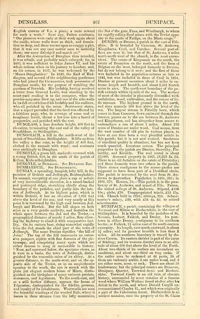
DUNGLASS.
■ir.7
DUNIPACE.
English crowns of V.s. a piece; a mete reward
for such a work." Next clay, Patten continues,
" Our pioneers were early at their work again about
the castle, whose walls were so thick, and founda-
tion so deep, and there too set upon so craggy a plot,
that it was not any easy matter soon to underdig
them; our army dislodged and march on."
After the destruction of Dunglass thus recorded,
it was rebuilt, and probably much enlarged; for, in
1603, it was sufficient to lodge James VI. and his
whole retinue when on his journey to London; and,
on his return, in 1617, he was welcomed by the
' Muses Dunglasides. 1 In 1640, the Earl of Had-
dington, and several of the neighbouring gentlemen
who had joined the Covenanters, took possession of
Dunglass castle, for the purpose of watching the
garrison of Berwick. His lordship, having received
a letter from General Leslie, was standing in the
court-yard reading it to the company, when the
powder-magazine blew up, and one of the side-walls
in its fall overwhelmed his lordship and his auditors,
who all perished in the ruins. Scotstarvet states,
that a report prevailed that the deed was effected by
a faithless page, who, in revenge of some real or
imaginary insult, thrust a hot iron into a barrel of
gunpowder, and perished with the rest.
DUNGLASS, a bare desolate height, 400 feet in
elevation, terminating the east end of the valley of
Strathblane, in Stirlingshire.
DUNGOIACH, a hill in the north-west of the
parish of Strathblane, Stirlingshire. It lifts up from
the valley a fine cone, to the height of 400 feet,
clothed to the summit with wood ; and contrasts
very strikingly to Dunglass.
DUNGYLE, a green hill, anciently crowned with
a strong British fort, in the south of the parish of
Kelton, Kirkcudbrightshire.
DUNGYLE, or Dunagoii.. See Dunagoil Bat.
DUNHAKDUIL. See Dundornadil.
DUNIAN, a spreading, lumpish, lofty hill, in the
parishes of Bedrule and Jedburgh, Roxburghshire.
Its summit, excepting at one place a cap or nobule
of very inconsiderable elevation, is a round-backed
and prolonged ridge, stretching chiefly along the
boundary of the parishes, and partly into the inte-
rior of Jedburgh. At its highest point, which is
■within Bedrule, it has an elevation of 1,031 feet
above the level of the sea; and very nearly at this
point it is traversed by the high road between Jed-
burgh and Hawick. But the hill slopes on both
sides in a very gentle acclivity, and bestrides the
whole space between the Jed and the Teviot, — a
geographical distance of nearly 3 miles, thus allow-
ing the highway to climb it with comparative faci-
lity. On its eastern base, rising somewhat rapidly
from the Jed, stands the chief part of the town of
Jedburgh. The name Dunian signifies ' the hill of
John.' The top of the hill commands an exten-
sive prospect, replete with fine features of the pic-
turesque, and comprising many spots which are
either famous in song or memorable in history.
" Near, and eastward below, the spectator views, as
it were in a basin, the town of Jedburgh, distin-
guished by the venerable ruins of its abbey. At a
greater distance, to the north-west, and on the op-
posite side of the Teviot, as in an amphitheatre
opening to the south, the eye is struck with the
plain yet elegant modem house of Minto, distin-
guished as the birthplace of many eminent patriots,
statesmen, and legislators. To the south-east, and
at a still farther distance, appears the house of
Edgerston, distinguished for the fidelity, prowess,
and loyalty of its inhabitants. Westwards are seen
the beautiful windings of the wooded Rule, where it
issues in three streams from the lofty mountains,
the Not o' the gate, Fana, and Windhurgh, to where
its rapidly rolling flood mixes with the Teviot oppo-
site to the castle of Fatlips, on the Minto crags."
DUNINO, or Denino, a parish in the cast of Fife-
shire. It is bounded by Cameron, St. Andrews,
Kingsbams, Crail, and Cambce. Several post-of-
fices are near it; but that of St. Andrews, 4 miles
north-north west of the church, is the most conve-
nient. The estate of Kingsmuir on the south, the
estate of Bonnyton on the north, and the farm of
Brigton on the west, belonged formerly to Dunino,
but do not belong to it now; and the first of these
was included in its population-returns so late as
1841, but was included in those of Crail in 1851.
Dunino at present measures about 3 miles in ex-
treme length and breadth, and about 2,431 Scotch
acres in area. The north-east boundary of the pa-
rish extends within 1 J mile of the sea. The surface
of most of the interior is pleasantly diversified with
undulation, wood, cultivation, and the course of lit-
tle streams. The highest ground is in the north,
and rises scarcely 300 feet above the level of the
sea. The largest stream is Pitmilly burn, which
comes in from Cameron, flows eastward through the
interior, passes on to the sea between St. Andrews
and Kingsbarns, and has altogether from source to
embouchure a run of about 7 miles. About 270
acres of Dunino are under wood. Coal seems, from
the vast number of old pits in various places, to
have at one time been a very plentiful article in
this parish; but it is not now worked. Sandstone
of excellent quality is abundant, but has not been
much quarried. Ironstone occurs. The principal
properties in the parish are Dunino, Stravithy, Pit-
tairthy, and Kinaldy. The real rental is about
£3,000. Assessed property in 1865, £4,305 5s. 3d.
There is an old fortalice on the estate of Pittairthy ;
and there formerly were two others in the parish.
Three stones contiguous to the manse-garden are
supposed to have been part of a Druidical circle.
The parish is traversed by the road from St. An-
drews to Anstruther. Population in 1831, 383; in
1861, 370. Houses, 70. — This parish is in the pres-
bytery of St. Andrews, and synod of Fife. Patron,
the united college of St. Andrews. Stipend, £198
16s.; glebe, £28. Unappropriated teinds, £33 15s.
lOd. Church built in 1826; sittings, 224. School-
master's salary, £40, with £34 4s. 6d. to retired
schoolmaster.
DUNIPACE, a parish, containing the villages of
Toi wood and Milton or Herbertshire, in the east of
Stirlingshire. It is bounded by the parishes of St.
Ninians, Larbert, Falkirk, and. Denny. Its post-
town is either Denny, contiguous to its southern
border, or Falkirk, 2J miles east of its south-eastern
extremity. Its length, east-south-eastward, is about
5J miles; and its greatest breadth is less than 3
miles. All its southern boundary is traced by the
river Carron. Its eastern district is part of the carse
of Stirling; and its western district rises to an alti-
tude of about 600 feet above the level of the Forth.
About two-thirds of its surface are incumbent on
sandstone, and about one-third on trap rocks. If
the entire area be reckoned at 46 parts, 38 of
them are variously arable, 5 are under wood, and 3
are either moss, moor, or rock. There are about 30
landowners; but the principal estates are Denovan,
Dunipace, Quarter, Torwood-head, and Herbert-
shire. Torwood Castle is an old ruin, of obscure
history, surrounded by some remains of a famous
wood where William Wallace found shelter after his
defeat in the north, and where Donald Cargill ex-
communicated Charles II., and which was originally
a part of the Caledonian forest. Herbertshire is an
ancient mansion, once the property of the St. Clairs
Set display mode to: Large image | Transcription
Images and transcriptions on this page, including medium image downloads, may be used under the Creative Commons Attribution 4.0 International Licence unless otherwise stated. ![]()
| Gazetteers of Scotland, 1803-1901 > Imperial gazeteer of Scotland, or, Dictionary of Scottish topography > Volume 1 > (585) Page 467 - DUN |
|---|
| Permanent URL | https://digital.nls.uk/97466150 |
|---|
| Description | Volume I: Aan-Gordon. |
|---|---|
| Attribution and copyright: |
|

