Imperial gazeteer of Scotland, or, Dictionary of Scottish topography > Volume 1
(380) Page 272 - CLA
Download files
Complete book:
Individual page:
Thumbnail gallery: Grid view | List view

CLACKMANNANSHIRE.
272
CLATT.
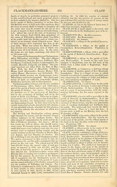
family of Argyle, in particular, possessed property
in this neighbourhood, and made perpetual grants
to their vassals in the manner alluded to. One feu
in the parish of Dollar, extending to no less than
200 Scottish acres, is held under this condition, that
the feuar or tenant shall be bound to slaughter all
the cattle that may be wanted for the use of the
family of Argyle in their residence of Castle-Camp-
bell. About the . end of the 16th, or beginning of
the 17th century, Lord Colvil, then proprietor of
the estate of Tillicoultry, divided about four-fifths
of the arable land into 40 feus, each of which con-
tained, on an average, about 30 Scotch acres. Most
of these tenures were converted into feus in the
year 1605. What was called the Mains of Dollar
was divided into 8 oxengates, each of which con-
tained from 30 to 45 Scotch acres. In the carse,
the farms are not large, containing only about 80
or 100 acres each.
The towns of Clackmannanshire are Clackmannan,
Alloa, Tillicoultry, and Dollar. The chief villages
are Newtonshaw, Sauchie, Kennet, Tullibody, Hot-
ton-Square, Coalyland, Cambus, Coalsnaughton, De-
vonside, Menstrie, Craigmill, and Abbey. The prin-
cipal mansions are Alloa Park, the Earl of Mar;
Shaw Park, the Earl of Mansfield; Tullibody
House, Lord Abereromby; Kennet House; Tilli-
coultry House ; Harvieston ; and Dollarfield. The
principal feudal remains are Clackmannan tower,
Alloa tower, and Castle-Campbell. The chief muni-
ments of trade are collieries, iron-works, tileries,
distilleries, breweries, and woollen factories.
Clackmannanshire contains only the four parishes
of Clackmannan, Alloa, Dollar, and Tillicoultry,
part of the parish of Logie, and perhaps also part of
the parish of Stirling. See Abbey. Two of these
six parishes are in the presbytery of Dunblane,
four in the presbytery of Stirling, and all in the
synod of Perth and Stirling. There are in Clack-
mannanshire seven Free churches, four United Pres-
byterian churches, two Independent chapels, and
one Episcopalian chapel. In 1837, there were in the
county 4 parochial schools, attended by 187 scholars,
1 5 non-parochial schools, attended by 905 scholars,
and 1 6 other schools, the attendance at which was
not reported.
The Stirling and Dunfermline railway passes
right through the county, and the Scottish Central
railway impinges on its northern border. The
other means of communication by roads and by the
frith of Forth are abundant. See Alloa. All the
law courts are held at Alloa, — the sheriff county
court every Wednesday during session, the sheriff
small debt court every ordinary court day, the com-
missary court as required dining session, and the
quarter sessions on the first Tuesday of March, May,
And August, and last Tuesday of October. The
jail of Stirling is also the jail of Clackmannanshire.
The prison assessment in this county is 2Jd., the
rogue-money 2d., and the police assessment 1 Jd. per
pound on the real rent. The valued rent in 1674,
was £26,482 Scots; the annual value of real pro-
perty as assessed in 1843, was £51,522; and the
real rent of heritable property as valued in 1850,
was £48,714 16s. Clackmannanshire unites with
Kinross-shire in sending one member to parliament;
but for this purpose, by provision of the Reform
bill, it comprises also "the Stirlingshire parish of
Alva, the Perthshire portion of the parish of Logie,
and the detached district of Perthshire, comprehend-
ing the parishes of Tulliallan and Culross. Par-
liamentary constituency in 1853, 1,149. Population
in 1801, 10,853; in 1811, 12,010; in 1821, 13,263;
in 1831, 14,729; in 1841, 19,155; in 1861, 33,543.
Inhabited houses in 1861. 2,996; uninhabited, 143;
building, 22. In 1849 the number of criminal
offenders was 80; the number of persons on the
poor roll was 673; and the amount of money raised
for the poor was £2,809 10s. 5d.
CLADlSH, an inn on the banks of Loch- Awe, 7
miles from Inverary, Argyleshire.
CLAIR INCH, a small island on the south side
of Inch-Cailleach, in the Stirlingshire part of Loch -
lomond.
CLAIRTOWN (St.). See Slnclalktows.
CLANYARD. See Kibkmaiden.
CLAONAIG. See Saddel.
CLAONARY, a village in the parish of Inverary,
Argyleshire.
CLAREBRAND, a village in the parish of
Crossmichael, Kirkcudbrightshire. Population in
1851, 54.
CLARENCEFIELD, a village with a post-office
in the parish of Ruthwell, Dumfries-shire. Popu-
lation, 86.
CLARKSTON, a village in the parish of Cath-
cart, Renfrewshire. It stands on the road from
Glasgow to Eaglesham, near the left bank of the
White Cart, 4 miles north of Eaglesham. Popu-
lation, 180.
CLARKSTON, or Cleekston, a thriving village
in the vicinity of Airdrie, parish of New Monkland,
Lanarkshire. Here is a chapel of ease, to which
formerly was attached a quoad sacra parochial terri-
tory, comprising the villages of Arden and Balloch-
ney, and containing a population of 4,526.
CLASHBENNIE. See Ebrol.
CLASHCARNOCH, a small harbour on the north
coast of the parish of Durness, 3 miles east of Cape
Wrath, Sutherlandshire. It has a slip for boats,
and is a point of communication with the neigh-
bouring lighthouse, hut lies much exposed to the
north.
CLASHMORE, a hamlet with a post-office in the
parish of Dornoch, in Sutherlandshire. It is the
nearest point to the Mickle ferry, which, before the
existence of Bonar bridge, was the only practicable
mode of reaching Sutherland and Caithness from
the south. The mail-coach here leaves the Skibc
road for Dornoch. There is a good inn here. A
fair for cattle is held on the Monday after the first
Wednesday of May.
CLASHNESSIE, a bay and a village in the parish
of Assynt, Sutherlandshire. The bay indents the
north coast of the parish ; and the village stands at
the head of the bay, 5^ miles north-west of Lochin-
ver. Population, 194.
CLATCHARD CRAG. See Abdie.
CLATHEY, a village nearly in the centre of the
parish of Gask, Perthshire. Population, 120.
CLATT, a parish, containing a village of its own
name, in the western extremity of the district of Ga-
rioch, Aberdeenshire. Its post-town is Old Rayne ;
and it is bounded by the parishes of Kinnethmont,
Leslie, Tullynessle, Auchindoir, and Rhynie. Its
length eastward is about 4 miles; and its breadth
is from 2 to 3 miles. The north-west boundary is
traced by the Bogie; and most of the interior is
drained eastward by the head-streams of the Gadie.
Part of the Suie and Coreen range of hills occupies
the southern border; some rising-grounds occur in
the north-west; and all the rest of the surface is
a plain lying at an elevation of about 600 feet above
sea-level. About 1,800 acres are undivided com-
mon; about 250 are in pasture; about 200 are under
wood; and most of the remainder, amounting to
about 2,800, are regularly or occasionally in til-
lage. The only landowners are Gordon of Knockes-
poch, who has a mansion in the parish, and Sir A.
Leith Hay of Rannes. Granite abounds, but only
Set display mode to: Large image | Transcription
Images and transcriptions on this page, including medium image downloads, may be used under the Creative Commons Attribution 4.0 International Licence unless otherwise stated. ![]()
| Gazetteers of Scotland, 1803-1901 > Imperial gazeteer of Scotland, or, Dictionary of Scottish topography > Volume 1 > (380) Page 272 - CLA |
|---|
| Permanent URL | https://digital.nls.uk/97463690 |
|---|
| Description | Volume I: Aan-Gordon. |
|---|---|
| Attribution and copyright: |
|

