Download files
Complete book:
Individual page:
Thumbnail gallery: Grid view | List view

BOELEY.
182
BOEEOWSTOWNNESS.
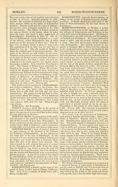
The total yearly value of raw produce was estimated
in 1843, at £17,133. Assessed property in 1860,
£10,526. The mansion of Earlston is a large, hand-
some, modem edifice in the midst of well-wooded
grounds. Plunton castle and the tower of Balman-
gan are fine ruins, belonging probably to the 15th
or 16th century. The village of Borgue stands in
the eastern district of the parish, about 2J miles
from the coast, and about 4 miles south-west of
Kirkcudbright. Population in 1851, 47. The vil-
lage of Kirkandrews stands contiguous to a creek
of the Solway, called Kirkandrews bay, 3 miles
Bouth-east of the entrance of Fleet bay. This vil-
lage was, in former times, a place of some note.
The population of it in 1841, was 47; and that of
Chapelton was 31. The old parish of Sandwick
forms the southern part of the present parish. The
ruins of its church are still visible on the coast.
Tradition relates that it was sacrilegiously plundered
of its plate by French rovers, sometime previous to
the Reformation; but that a storm wrecked the
vessel on a rock nearly opposite the church, where
the pirates perished. It is called the Frenchman's
rock. The church of Kirkandrews originally be-
longed to the monks of Iona. When the devasta-
tions of the Danish pirates left them without an
establishment, William the Lion transferred it, along
with their churches and estates in Galloway, to the
monks of Holyrood. It afterwards fell into the
hands of the prior and canons of Whithorn. The
rains of it still exist. Population of the parish in
1831, 894; in 1861, 1,162. Houses, 203.
This parish is in the presbytery of Kirkcudbright,
and synod of Galloway. Patron, the Crown. Sti-
pend, £230 16s. 10d.; glebe, £29. Schoolmaster's
salary now is £70, with £36 fees, and £50 other
emoluments. The parish church was built in 1814,
and contains about 500 sittings. It is a handsome
Gothic structure, and stands on a conspicuous site.
There is a Free church: attendance. 170; yearly
sum raised in 1865, £127 15s. 7jd. There is a pri-
vate school.
BORLAND. See Boeeland.
BOELEY (Loch), a small lake in the parish of
Durness, north of Sutherlandshire, containing abun-
dance of a species of trouts called Red bellies, which
are only fished for in October.
BOROUGH HEAD, the promontory at the south-
ern extremity of the parish of Whitehorn, and east
side of the entrance of Luce Bay, Wigtonshire. It
forms a projection at the extreme south of Scotland
similar to the Mull of Galloway; and it terminates
in bold cliffs, 200 feet high, and pierced with caves.
BOROUGH-MOOR, a tract of ground, formerly
an open common, in the parishes of St. Cuthbert
and Liberton, Edinburghshire. It lies adjacent to
the south side of the city of Edinburgh. In the
west end of it once stood a large chapel dedicated to
St. Eoque; and round this was a cemetery where
those who died of the plague were interred. The
town-council, in 1532, granted four acres of ground
in the Borough-moor to Sir John Young the chap-
lain, for which he was bound to keep the roof and
windows of the chapel in repair; but at the Reforma-
tion the church and churchyard were converted into
private property. A part of the walls of this chapel
are still standing ; Grose has preserved a view of it.
This moor appears, in 1513, to have abounded with
large oak-trees; and here James IV. reviewed his
army before he marched to the fatal battle of Flod-
den-field. See Edinburgh.
BORROWSTOWN, a hamlet on the coast of the
parish of Reay, 6 miles west of Thurso, Caithness-
shire. Near it are a number of small caves and a
strong natural arch.
BORROWSTOWN— formerly Burwardstown— a
village in the parish of Borrowstownness, Linlith-
gowshire. It stands about § of a mile south of the
town of Borrowstownness, on the road thence to
Linlithgow.
BORROWSTOWNNESS, or Bo'kess, a parish
containing a post-town of the same name, and also
the villages of Borrowstown and Newtown, in the
north-west corner of Linlithgowshire. It is bounded
by Stirlingshire, the frith of Forth, and the parishes
of Carriden and Linlithgow. Its length eastward is
about 4 miles; and its average breadth is about
2 miles. The river Avon traces all the bouudary
with Stirlingshire. The highest ground in the
parish is Irongath Hill or Glour-o'er-'em, situated
in the south-east corner, rising to the height of 520
feet above the level of the frith, and commanding a
very extensive and beautiful prospect. A tract of
flat rich alluvium, called the carse of Kinniel, lies in
the north-west; and the beach thence eastward is
low ground between a high bank landward and a
great expanse of muddy silts at ebb tide seaward.
All the rest of the parish declines gradually from
Irongath Hill to the west and north. The soil is a
deep loam well-cultivated. There are several ex-
cellent coal-pits; ironstone also abounds; and there
are great beds of limestone, but of bad quality.
Quarries of freestone and whinstone are wrought.
The house of Kinniel, long inhabited by the vener-
able and accomplished metaphysician, Dugald Stew-
art, is a seat of the Hamilton family, and as such is
frequently mentioned in history. Antoninus' Wall
traversed the parish, and had a fort in it, and is
thought by some to have terminated here. The
Duke of Hamilton is the only heritor. The real
rental is about £14,700. In 1774 an embankment,
1J mile in length, was made westwards from the
town along the north side of the carse of Kinniel,
with the view not of gaining but of saving ground
from the sea. It has answered this purpose very
well, and effectually protects about 450 acres of
carse-land, at present rented at £4 4s. per acre.
Population of the parish in 1831,2,809; in 1861,
5,698. Houses, 609. The increase of population
has arisen from the working of coal and iron mines.
Assessed property in 1860, £25,917.
This parish is in the presbytery of Linlithgow,
and synod of Lothian and Tweeddale. Patron, the
Duke of Hamilton. Stipend, £272 7s. 7d. ; glebe,
£21. Schoolmaster's salary now is £55, with £60
fees. The parish church is situated in the town of
Borrowstownness. It was repaired and partly re-
built in 1820, and contains 950 sittings. There is
a Free church for Borrowstownness and Carriden :
attendance from 300 to 400; yearly sum raised in
1865, £173 Is. 9Jd. There is an United Presby-
terian church in the town, containing about 400 sit-
tings. There are several private schools. — Prior
to the middle of the 17th century, Kinniel was the
name of the parish ; but the inhabitants of Borrows-
townness having built a church for themselves, the
town was created a separate parish. In 1669, the
Duke of Hamilton procured an act of parliament for
uniting the two districts ; and since that time the
old landward church of Kinniel has been neglected,
though the burying-ground remains. There was a
considerable town of Kinniel long before the found-
ing of the town of Borrowstownness ; but it has
completely disappeared.
The Town of Bokrowstownness is a sea-port and
a burgh of barony, 3 miles north of Linlithgow, 8
east by north of Falkirk, and 9 west-north-west of
South Queensferry. It is situated on a low penin-
sula washed by the Forth, at the north-east corner
of the parish, only a few feet above high water-mark.
Set display mode to: Large image | Transcription
Images and transcriptions on this page, including medium image downloads, may be used under the Creative Commons Attribution 4.0 International Licence unless otherwise stated. ![]()
| Gazetteers of Scotland, 1803-1901 > Imperial gazeteer of Scotland, or, Dictionary of Scottish topography > Volume 1 > (282) Page 182 |
|---|
| Permanent URL | https://digital.nls.uk/97462514 |
|---|
| Description | Volume I: Aan-Gordon. |
|---|---|
| Attribution and copyright: |
|

