Imperial gazeteer of Scotland, or, Dictionary of Scottish topography > Volume 1
(255) Page 157 - BER
Download files
Complete book:
Individual page:
Thumbnail gallery: Grid view | List view
BERWICK (North).
157
BERWICKSHIRE.
was often called in old times South Berwick. The
town ranks at once as post-town, market-town,
watering-place, sea-port, and royal burgh ; it con-
sists principally of two streets nearly at right angles
to each other ; it was greatly enlarged and improved
during the twelve years ending in 1865 ; it has a
large puhlic hotel, a good private hotel, and, on
both sides, commodious new villas for summer vis-
itors; it acquired a howling-green in 1865; and it
looks all healthiness and cheerfulness, and is sur-
rounded on sea and land by very beautiful environs.
The beach on both sides of the harbour presents
fine gently sloping sands, and forms excellent bath-
ing-ground ; the links afford good scope for the
healthy diversion of golfing; and the frith, the
rocky "isles, the low trap hills to landward, and
especially North Berwick law, immediately south
of the town, with a rich skirt of wood and a delight-
ful zigzag walk to the summit, comprise enough of
scenery to give very pleasing exercise to the ima-
gination. The result is that North Berwick is a
select place, — attracting a larger proportion of
wealthy and well-informed visitors than most towns
of its size.
North Berwick was created a royal burgh by Ro-
bert III., and received a confirmation of its privi-
leges by charter from James VI. The parliamen-
tary boundaiy extends from the Yellow Craig rock
on the east, to Point Garry on the west — a distance
of nearly a mile in a direct line, but considerably
more by the curvatures of the coast — with an aver-
age breadth betwixt the shore and the southern
boundary line of about 360 yards. The burgh joins
with Haddington, Dunbar, Jedburgh, and Lauder,
in returning a member to parliament. The parlia-
mentary constituency in 1865 was 87. The town
is said to have been a sea-port so early as the time
of Robert II.; it is said also to have been a place of
noticeable trade some time or other long ago. But
Mr. Tucker, in his enumeration of the ports of Scot-
land in 1656, does not even mention North Berwick,
though he notices Eyemouth and Dunbar, and the
minor ports of the Forth up to Borrowstounness.
In the report of the commissioners appointed by the
convention of royal burghs, in 1691, to visit the
different burghs, and report upon their condition,
it is stated " that there were neither yearly fairs
nor weekly markets ; " and the other observations
on its trade are summed up in these words, " ships
they have none, nor ferry boat, except two fish-boats
which pay nothing to the town." At the present
day the harbour is formed by a tolerably good pier,
on which considerable sums have been laid out ;
but it is dry at low water, and neither very easy of
access, nor very well sheltered when gained. There
were in 1834 five vessels belonging to the port,
amounting in burden to 249 tons ; and in 1850 there
were four vessels, amounting in burden to 270 tons.
For fifty years the trade may be considered to have
been stationary, the letting of the customs and
shore dues having varied very immaterially during
the greatest part of that time. "There has latter-
ly," say the Parliamentary commissioners, " been a
great falling-off in the grain and lime trade; but
new objects of traffic have sprung up in the export
of potatoes, turnips, and flour ; and within the last
ten years there has been a considerable increase in
the importation of foreign rape cake, and crashed
bones for manure. There are no manufactures, and
no traces of any such ever having existed in the
burgh. There are still no regular markets, and
only two annual fairs, one in the month of June,
and the other in the month of November." A weekly
stock grain-market was recently established, with
seemingly good prospect of success; but it lasted
only three months, and docs not appear at all likely
to be resumed. The revenue of the burgh, in 1833,
was £141 18s., of which £85 arose from customs and
shore-dues. The expenditure during the same year
was £124 5s. 2d.; and the debt amounted to £794
19s. 8d. The revenue in 1863 was about £380.
The municipal government is vested in 12 council-
lors, who elect 2 bailies, and a treasurer. Munici-
pal constituency in 1865, 59. The town-clerk is
appointed by the magistrates during pleasure, and
has a salary of £10 10s. There is no regular burgh-
court; but sheriff small-debt courts are held three or
four times in the year. The burgesses have a right
of commouty on the links on both sides of the town.
In 1814, the town-council sold the island of Craig-
leith, lying off the harbour, to Sir Hew Dalrymple
for £400. The town has an office of the British
Linen Company's Bank. It has also a subscrip-
tion library, and two or three benevolent societies.
A branch of the North British railway deflects at
Drem, and rata north-eastward to a terminus at
North Berwick. There are several passenger trains
daily ; and there is a station for Dirleton about
midway between Drem and North Berwick. Popu-
lation of the municipal burgh of North Berwick in
1841, 607; in 1861, 700. Houses, 114. Population
of the parliamentary burgh in 1841, 1,037 ; iu 1861,
1,164. Houses, 179.
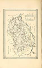
BERWICKSHIRF., the most south-easterly county
of Scotland, lying on the coast of the German ocean,
and along the north-east border of England. Its
principal division was anciently called the Merse,
or March, a name which it still retains, and which
probably signifies the Border-district, or frontier-
province. But this district seems formerly to have
included a considerable portion of the eastern low-
lands of Teviotdale, as Roxburgh castle was an-
ciently called Marchmount, or the Castle of the
March or Merse. This denomination, the Merse,
is still often used, loosely, for the whole county.
The modern name, Berwickshire, is derived from
the town of Berwick-upon-Tweed, once its chief
burgh or county town; but which, after the demise
of Elizabeth, and the accession of James VI. of
Scotland to the English throne, was constituted a
peculiar jurisdiction, hypothetieally separate from
both kingdoms, and virtually forming a distinct
county.
Berwickshire is bounded on the east by the Ger-
man ocean ; along which, from the boundaries of
Berwick township to St. Abb's Head, its coast trends
north-north-west for 8J miles. The shore then
takes a west-north-west direction, for other 9 miles,
till its junction with East Lothian at Dunglass
Vidge; and, by the revenue laws, this latter part
of the coast is considered as being within the limits
of the frith of Forth. Almost the whole of this
coast consists of bold rocky precipices of consider-
able altitude ; and is nearly inaccessible, except at
Eyemouth and Coldingham bays, and two or three
other places, which are accessible to fishing-boats,
at sandy or gravel beaches at the foot of the rocks.
The whole irregular northern boundary skirts with
East Lothian, along the mountain-range of Lam
mennoor. But, within this line, Berwickshire en-
tirely surrounds a detached portion of one of the
East Lothian parishes ; while the most northerly
part of this county is situated beyond, or to the
north of, the Lammermoor hills, and is continuous
with the extensive and fertile vale of the Lothians.
Clinthill, one of the highest of the Lammermoor
chain, in the parish of Channelkirk, at the north-
western extremity of the county, rises 1,544 feet
above the level of the ocean. Lammerlaw, in the
parish of Lauder, has an altitude of 1,500 feet. The
157
BERWICKSHIRE.
was often called in old times South Berwick. The
town ranks at once as post-town, market-town,
watering-place, sea-port, and royal burgh ; it con-
sists principally of two streets nearly at right angles
to each other ; it was greatly enlarged and improved
during the twelve years ending in 1865 ; it has a
large puhlic hotel, a good private hotel, and, on
both sides, commodious new villas for summer vis-
itors; it acquired a howling-green in 1865; and it
looks all healthiness and cheerfulness, and is sur-
rounded on sea and land by very beautiful environs.
The beach on both sides of the harbour presents
fine gently sloping sands, and forms excellent bath-
ing-ground ; the links afford good scope for the
healthy diversion of golfing; and the frith, the
rocky "isles, the low trap hills to landward, and
especially North Berwick law, immediately south
of the town, with a rich skirt of wood and a delight-
ful zigzag walk to the summit, comprise enough of
scenery to give very pleasing exercise to the ima-
gination. The result is that North Berwick is a
select place, — attracting a larger proportion of
wealthy and well-informed visitors than most towns
of its size.
North Berwick was created a royal burgh by Ro-
bert III., and received a confirmation of its privi-
leges by charter from James VI. The parliamen-
tary boundaiy extends from the Yellow Craig rock
on the east, to Point Garry on the west — a distance
of nearly a mile in a direct line, but considerably
more by the curvatures of the coast — with an aver-
age breadth betwixt the shore and the southern
boundary line of about 360 yards. The burgh joins
with Haddington, Dunbar, Jedburgh, and Lauder,
in returning a member to parliament. The parlia-
mentary constituency in 1865 was 87. The town
is said to have been a sea-port so early as the time
of Robert II.; it is said also to have been a place of
noticeable trade some time or other long ago. But
Mr. Tucker, in his enumeration of the ports of Scot-
land in 1656, does not even mention North Berwick,
though he notices Eyemouth and Dunbar, and the
minor ports of the Forth up to Borrowstounness.
In the report of the commissioners appointed by the
convention of royal burghs, in 1691, to visit the
different burghs, and report upon their condition,
it is stated " that there were neither yearly fairs
nor weekly markets ; " and the other observations
on its trade are summed up in these words, " ships
they have none, nor ferry boat, except two fish-boats
which pay nothing to the town." At the present
day the harbour is formed by a tolerably good pier,
on which considerable sums have been laid out ;
but it is dry at low water, and neither very easy of
access, nor very well sheltered when gained. There
were in 1834 five vessels belonging to the port,
amounting in burden to 249 tons ; and in 1850 there
were four vessels, amounting in burden to 270 tons.
For fifty years the trade may be considered to have
been stationary, the letting of the customs and
shore dues having varied very immaterially during
the greatest part of that time. "There has latter-
ly," say the Parliamentary commissioners, " been a
great falling-off in the grain and lime trade; but
new objects of traffic have sprung up in the export
of potatoes, turnips, and flour ; and within the last
ten years there has been a considerable increase in
the importation of foreign rape cake, and crashed
bones for manure. There are no manufactures, and
no traces of any such ever having existed in the
burgh. There are still no regular markets, and
only two annual fairs, one in the month of June,
and the other in the month of November." A weekly
stock grain-market was recently established, with
seemingly good prospect of success; but it lasted
only three months, and docs not appear at all likely
to be resumed. The revenue of the burgh, in 1833,
was £141 18s., of which £85 arose from customs and
shore-dues. The expenditure during the same year
was £124 5s. 2d.; and the debt amounted to £794
19s. 8d. The revenue in 1863 was about £380.
The municipal government is vested in 12 council-
lors, who elect 2 bailies, and a treasurer. Munici-
pal constituency in 1865, 59. The town-clerk is
appointed by the magistrates during pleasure, and
has a salary of £10 10s. There is no regular burgh-
court; but sheriff small-debt courts are held three or
four times in the year. The burgesses have a right
of commouty on the links on both sides of the town.
In 1814, the town-council sold the island of Craig-
leith, lying off the harbour, to Sir Hew Dalrymple
for £400. The town has an office of the British
Linen Company's Bank. It has also a subscrip-
tion library, and two or three benevolent societies.
A branch of the North British railway deflects at
Drem, and rata north-eastward to a terminus at
North Berwick. There are several passenger trains
daily ; and there is a station for Dirleton about
midway between Drem and North Berwick. Popu-
lation of the municipal burgh of North Berwick in
1841, 607; in 1861, 700. Houses, 114. Population
of the parliamentary burgh in 1841, 1,037 ; iu 1861,
1,164. Houses, 179.
BERWICKSHIRF., the most south-easterly county
of Scotland, lying on the coast of the German ocean,
and along the north-east border of England. Its
principal division was anciently called the Merse,
or March, a name which it still retains, and which
probably signifies the Border-district, or frontier-
province. But this district seems formerly to have
included a considerable portion of the eastern low-
lands of Teviotdale, as Roxburgh castle was an-
ciently called Marchmount, or the Castle of the
March or Merse. This denomination, the Merse,
is still often used, loosely, for the whole county.
The modern name, Berwickshire, is derived from
the town of Berwick-upon-Tweed, once its chief
burgh or county town; but which, after the demise
of Elizabeth, and the accession of James VI. of
Scotland to the English throne, was constituted a
peculiar jurisdiction, hypothetieally separate from
both kingdoms, and virtually forming a distinct
county.
Berwickshire is bounded on the east by the Ger-
man ocean ; along which, from the boundaries of
Berwick township to St. Abb's Head, its coast trends
north-north-west for 8J miles. The shore then
takes a west-north-west direction, for other 9 miles,
till its junction with East Lothian at Dunglass
Vidge; and, by the revenue laws, this latter part
of the coast is considered as being within the limits
of the frith of Forth. Almost the whole of this
coast consists of bold rocky precipices of consider-
able altitude ; and is nearly inaccessible, except at
Eyemouth and Coldingham bays, and two or three
other places, which are accessible to fishing-boats,
at sandy or gravel beaches at the foot of the rocks.
The whole irregular northern boundary skirts with
East Lothian, along the mountain-range of Lam
mennoor. But, within this line, Berwickshire en-
tirely surrounds a detached portion of one of the
East Lothian parishes ; while the most northerly
part of this county is situated beyond, or to the
north of, the Lammermoor hills, and is continuous
with the extensive and fertile vale of the Lothians.
Clinthill, one of the highest of the Lammermoor
chain, in the parish of Channelkirk, at the north-
western extremity of the county, rises 1,544 feet
above the level of the ocean. Lammerlaw, in the
parish of Lauder, has an altitude of 1,500 feet. The
Set display mode to: Large image | Transcription
Images and transcriptions on this page, including medium image downloads, may be used under the Creative Commons Attribution 4.0 International Licence unless otherwise stated. ![]()
| Gazetteers of Scotland, 1803-1901 > Imperial gazeteer of Scotland, or, Dictionary of Scottish topography > Volume 1 > (255) Page 157 - BER |
|---|
| Permanent URL | https://digital.nls.uk/97462190 |
|---|
| Description | Volume I: Aan-Gordon. |
|---|---|
| Attribution and copyright: |
|
| Description | Compiled from the most recent authorities, and forming a complete body of Scottish geography, physical, statistical, and historical. Edited by the Rev. John Marius Wilson. Illustrated with a complete county atlas, various chorographical maps, plans of ports, harbours, and interesting views. London: A. Fullarton & Co., [n.d.]. 2 volumes. Title page verso in Volume 1: Edinburgh: Fullarton and MacNab, Printers, Leith Walk. |
|---|---|
| Shelfmark | Gazetteers,(strong room) |
| Additional NLS resources: | |
| Description | 20 volumes of the most popular descriptive gazetteers of Scotland, providing a comprehensive geographical encyclopaedia of Scotland in the 19th century. Principal places in Scotland, including towns, counties, castles, glens, antiquities and parishes, are listed alphabetically. Each entry includes detailed historical and geographical information about each place. |
|---|---|