Download files
Complete book:
Individual page:
Thumbnail gallery: Grid view | List view

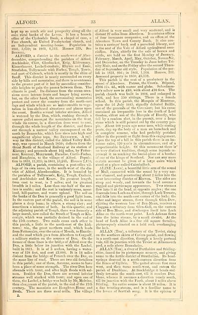
ALFOED.
33
ALLAN.
kept up so much stir and prosperity along all the
once rural hanks of the Leven. It has a branch
office of the Clydesdale Bank, a chapel of ease, a
Free church, ail United Presbyterian church, and
an Independent meeting-house. Population in
1841, 3,039; in 1801, 4,2*2. Houses 339. See
Bo.nhill.
ALFOKD, a district in the south-west of Aber-
deenshire, comprehending the parishes of Alford,
Auchindoir, Clatt, Glenbueket, Keig, Kildrmnmy,
Kinnethmont, Loehell-cushnie, Ehynie and Essie,
Strathdon, Tullynessle with Forbes, Tough, Towic,
and part of Cabrach, which is mostly in the shire of
Banff. This district is nearly surrounded on every
side by hills and mountains, and there is no entrance
to the greater part of it but by ascending consider-
able heights to gain the passes between them. The
climate is good. Its distance from the ocean occa-
sions more intense frosts and longer lying snows;
hut, on the other hand, the surrounding mountains
protect and cover the country from the north-east
fogs and winds which are so unfavourable to vege-
tation in less-sheltered situations and places upon
the coast. Besides several inferior streams, Alford
is watered by the Don, which, rushing through a
narrow gullet amongst the mountains on the west,
winds its course, in a direction from west to east,
through the whole length of the district, and flows
out through a narrow valley encompassed on the
north by Bennochie, which here rises into high and
magnificent alpine tops. See Bexxochie. A rail-
way for this district, called the Alford Valley Rail-
way, was opened in March 1859; deflects from the
Great North of Scotland Railway at its station of
Kintore; and proceeds about 16J miles, by Fetter-
near, Kemnay, Mqnymusk, Paradise, Castle-Forbes,
and Haughton, to the village of Alford. Popula-
tion in 1831, 11,923; in 1861,13,241. Houses 2,470.
ALFOED, a parish, containing a post-office vil-
lage of its own name, in the south-west of the dis-
trict of Alford, Aberdeenshire. It is bounded by-
the parishes of Tullynessle, Keig, Tough, Cuslmie,
and Auchindoir and Keara. Its greatest length,
from east to west, is 7 miles; and its greatest
breadth is 3 miles. Less than one-half of the sur-
face is arable; and the rest is variously moss, moor-
land, hill-pasture, and waste upland. The soil on
the banks of the Don is generally a good light loam.
In the eastern part of the palish, the soil is in some
places a deep loam ; in others, a strong clay ; and
sometimes a mixture of both. In this quarter, and
the adjoining parish of Tough, there was formerly a
large marsh, now called the Strath of Tough or Kin-
craigie, which was partially drained in the end of
the 17th century. Two roads cross each other in
this parish, a little to the north-east of the kirk-
town: viz., the great northern road, which leads
from Fettercaim , over the cairn of Month, to Huntly ;
and the road which goes from Aberdeen to Corgarff,
a military station on the sources of Don. On the
former of these lines is the bridue of Alford over the
Don, a little below its junction with the Lochel,
built in 1811. It is of 3 arches, having a water-
way of 128 feet, and cost £2,000. It is 14 miles
distant from the bridge of Potarch over the Dee, on
the same line of road. There are two old fortalices
in this parish; one of them, Astoune, seems to have
been a place of some strength. The river Don here
abounds with trout, and after high floods with sal-
mon. Besides the Don, there are several inferior
streams well stocked with trout; and upon one of
them, the Loehel, a bridge was built by Mr. Melvine,
then clergyman of the parish, in the end of the 17th
century. The mansions are Haughton-House and
Breda. There are three meal-mills. The village
of Alford is very small and very scattered, ami iB
distant 27 miles "from Aberdeen. It contains offices
of four insurance companies, and an office ol the
Aberdeen Town and County Bank. It also con-
tains a savings' bank and a parochial library, and
is the seat of the Vale of Alford agricultural asso-
ciation. Fairs, chiefly for the sale of horses and
cattle, are held on the first Monday of January,
February, March, April, May, October, NovemBer,
and December, on the Tuesday in June before Tri-
nity Muir, and on the Friday after the second Thurs-
day of September old style. Population of the par-
ish in 1831, 894; in 1861, 1,264. Houses, 217.
Assessed property in 1860, £5,752.
This parish is the seat of a presbytery in. the
synod of Aberdeen. Patron, the Crown. Stipend,
£206 17s. 4d., with manse and glebe. Schoolmas-
ter's salary now is £40, with about £10 fees. The.
parish church was built in 1804, and enlarged in
1826, and has 500 sittings. There is a female
school. In this parish, the Marquis of Montrose,
upon the 2d July 1645, signally defeated Baillie,
one of the generals of the Covenant; but his cause
sustained an irreparable loss in the death of Lord
Gordon, eldest son of the Marquis of Huntly, who
fell by a random shot, in the pursuit, near a large
stone which is still pointed out by the country peo-
ple. About 100 years ago some men, while casting
peats, dug up the body of a man on horseback and
in complete armour, "who had probably perished
either in the pursuit or flight from this engagement.
Upon the top of a hill in this parish there is an im-
mense cairn. 120 yards in circumference, and of a
proportionable height. Of this monument there is
no veiy distinct tradition, though some legends re-
present it as marking the burial-place of a brother
of one of the kings of Scotland. Nor can any more
certain account be given of a large cairn which
stood at a place called Caimballoch.
ALINE (Loch), a beautiful little arm of the sound
of Mull, connected with the sound by a very nar-
row channel, and penetrating about 2 miles into the
most interesting district of Morven. The sides are
steep and woody, and towards the head assume a
nigged and picturesque appearance. Two streams
flow into it at the head, at opposite angles ; the one
descends from Loch-na-Cuim, through Loch Temate,
and falls into the north-east corner of the loch; the
other and larger stream, flows through Glen-Dow,
skirting the western base of Ben-Mean, receives at
Claggan a tributary from Glen-Gell, on the eastern
side of Ben-Mean, and discharges itself into Loch
Aline on the north-west point. Loch Arienas flows
into the latter stream, by a small rivulet. At the
head of Loch Aline is a fine old square fortalice,
picturesquely situated on a bold rock overhanging
the loch.
ALLAN (The), a tributary of the Teviot, rising
on the southern skirts of Cavers parish, and flowing
in a north-east direction, through a lovely pastoral
vale, till its junction with the Teviot at Allanmouth
peel, a mile above Branxhohn.
ALLAN (The), a river of Perthshire and Stirling-
shire, famed for its picturesque scenery, and giving
name to the fertile district of Strathallan. Its head-
springs descend in a south-eastern direction from
the Braes of Ogilvie. The united stream first runs
west, and then turns south-west, and enters the
parish of Dunblane. At Stockbridge it bends sud-
denly towards the south-east, till it reaches Dun
blane, whence it assumes a direction nearly south,
till its junction with the Forth, about 2 miles above
Stirling. Its entire course is about 18 miles. It is
a fine trouting-stream, and is a familiar name to
the lovers of Scottish song. It is the opinion of
n
Set display mode to: Large image | Transcription
Images and transcriptions on this page, including medium image downloads, may be used under the Creative Commons Attribution 4.0 International Licence unless otherwise stated. ![]()
| Gazetteers of Scotland, 1803-1901 > Imperial gazeteer of Scotland, or, Dictionary of Scottish topography > Volume 1 > (123) Page 33 |
|---|
| Permanent URL | https://digital.nls.uk/97460606 |
|---|
| Description | Volume I: Aan-Gordon. |
|---|---|
| Attribution and copyright: |
|

