Topographical, statistical, and historical gazetteer of Scotland > Volume 2
(699) Page 679 - SOL
Download files
Complete book:
Individual page:
Thumbnail gallery: Grid view | List view

SOLWAY FRITH.
67i»
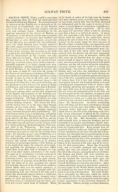
SOLWAY FRITH (The), a gulf or very large
bay, projecting from the Irish sea north-eastward
between Scotland and England. Its commencement
or entrance on the English side is obviously at St.
Bee's-head in Cumberland; but, on the Scottish
side, is far from being distinctly marked, and has
been very variously stated. Burrowbead, at the
southern extremity of the district of Machars in
Wigtonshire, is the furthest and the most commonly
assigned entrance ; yet between that headland and
Balmae-head or even Balcarry-point, respectively
14 and 24i miles in a straight line east-north-east-
ward, the whole Scottish coast directly confronts
the entire expanse of the Irish sea. Measured from
Burrowbead, it extends about 5S miles in length and
37 miles at the entrance; but measured, as we think
it ought to be, from Balcarry-point, it is little more
half the measurement at the entrance, and only
about 33£ miles in length. From Balcarry-point to
the little estuary of the Pow in the parish of Cum-
mertrees, it extends nearly direct north-eastward, —
gradually contracts in its limits, though with occa-
sional expansions, — and has a breadth in the maximum
of about 19 miles, in the minimum of about 8, and
in the mean of about 13; and from the estuary of
the Pow to its termination — a distance of 12 miles —
it extends, in an easterly direction, and has a varying
breadth of from H mile to 3f miles, and a mean
breadth of about 2*, — the maximum being at the
estuary of the Pow and in the parish of Gretna, and
the minimum in a line between the parish of Annan
and Bowness, and in the short space east of Redkirk-
point. The frith's marine expansions, and its re-
ceptions of running water, are few and unimportant
on the English side compared to the Scottish, and,
such as they are, belong to the hydrographical topo-
graphy of England. The Sark, the Kirtle, and some
smaller streams enter it on the Dumfries-shire coast,
without forming estuaries. The Annan, the Pow,
and the Lochar enter it on the same coast through
estuaries of but small extent. The Nith, before
entering it, forms a long and gradually expanding
estuary between Dumfries-shire and Galloway. The
chief streams which enter it in Galloway, calculating
to the extreme point of Burrowhead, are the South-
wick, the Urr, the Dee, the Fleet, the Cree, and the
Bladenoch; and its principal marine expansions with-
in the same range of sea-board, are the estuary of the
Urr, Auchencairn-bay, Kirkcudbright-bay, Fieet-bav,
and, chief of all, Wigton-bay. The coast along
Dumfries-shire is low and sandy, and ascends by an
exceedingly low gradient from the line of high-water
mark ; but along the greater part of Galloway it is
bold and rocky, and exhibits cliffs, caverns, pinna-
cles, isolated rocks, and a variegated rampart in such
frequent and curious combinations as to produce
abundance of picturesque scenery. — >The Solway, as
to the depth of its water, the character of its beach,
and especially the phenomena of its tides, differs
widely from every other frith in Scotland, or even
from every other marine indentation in the world.
The cause of its peculiarities is briefly explained in
the section, ' Marine waters,' in our general in-
troductory article, and needs not be again noticed.
Over a distance of probably about 20 miles from its
head, the whole of its bed, excepting the narrow
and canal-like channels of the Nith and the confluent
waters which enter near the eastern extremity, is
alternately a surgy brown sea, tinctured with silt,
and oscillating with the rebound of the tide, and a
naked, flat, unrelieved expanse of sand, a wilderness
ot desolation, a miniature Sahara, strangely inter-
posing its dark and dreary projection between the
blooming slopes of Cumberland and the finely out-
lined and warmly tinted lands of Scotland. Much
of its beach, or rather of its bed, even its broader
and more seaward parts, is of the same character ;
so very much, indeed, that were the frith estimated
or admeasured only by the space it covers at low-
water, it would figure in comparative insignificance,
or exceedingly limited proportions. All its tides
are rapid, and constitute rather a rush or careering
race than a flow or a current of waters, A spring
tide, but especially a tide which runs before a stiif
breeze from the south or the south-west, careers
along at the rate of from 8 to 10 miles an hour; it
is heard by the people along the shore upwards of
20 miles before it reaches them, and approaches with
a hoarse and loud roar, and with a brilliance of phe-
nomena and demonstration, incomparably more sub-
lime than if the wide sandy waste were densely
scoured with the fleetest and the most gorgeously
appointed invading army of horsemen ; before the
first wave can be descried from the shore, a long
cloud or bank of spray is seen, as if whirling on an
axis, and evanescently zoned and gemmed with mimic
rainbows, and the rich tintings of partial refractions,
sweeping onward with the speed of a strong and
steady breeze; then follows a long curved white and
flowing surf; and when the magnificent banner of
spray, and this surfy pioneer have made distinct an-
nouncement, finally and suddenly appears the majestic
van of the tide, a speckled and deeply dimpled body
of waters, from 3 to 6 feet high a-breast, rolling
impetuously forward, and bringing elosely in its rear
a tumbling and tempestuated mass of marine vales
and hillocks, glittering and gorgeous all over with
the most fitful play of the prismatic colours. As
the tide enters the contracted parts of the frith and
the lower parts of the side estuaries, it acquires such
additional features of romance and novelty as render
it altogether an object per se, and one of the most
interesting that can form a main feature of any land-
scape : See Glencaple. Accidents occasionally
occur with ships, and have been very frequent, though
much less so of lute years than before, with persons
venturing within high-water mark. The rivers
which traverse the bed of the frith being easily ford-
able, strong inducement is offered by the shortness
of the path to cross the sands to England during the
recess of the tide. But Scotchmen, even when
well-mounted, have, in numerous instances, and oc-
casionally to an amount constituting a literal catas-
trophe, been overtaken and drowned, while returning
from the Cumberland fairs. Even persons best ac-
quainted with the locality are liable to be mistaken
in their calculations of the time when the tide will ap-
proach; and, when they have proceeded partly across,
may hear the appalling sound of the watery invasion
so near and menacing, that a clear atmosphere, a good
steed, much self-collectedness, and a steady remem-
brance of the direction of the path, may all be neces-
sary for their preservation. Dense fogs frequently
arise, and so bewilder professed and experienced
guides, that they can proceed in safety only with
the aid of the compass; and quicksands are occasion-
ally formed, and fitfully shift their localities, ob-
scurely but awfully menacing every intruder who
has not watched the impressions made upon the
ground by almost every successive tide. — The fish-
eries of the Solway are extensive and various. Some
curious particulars respecting their former condition,
as every reader of Sir Walter Scott's novels knows,
are worked into the tissue of the most stirring inci-
dents in the tale of Redgauntlet. The mode of fish-
ing is principally by stake-nets, which are wholly
submerged by the tide, and which, when the tide is
out, contribute their lank proportions and thoroughly
prosaic appearances to the pervading dreariness of
the landscape. Salmon, herling, sea-trout, flounders,
Set display mode to: Large image | Transcription
Images and transcriptions on this page, including medium image downloads, may be used under the Creative Commons Attribution 4.0 International Licence unless otherwise stated. ![]()
| Gazetteers of Scotland, 1803-1901 > Topographical, statistical, and historical gazetteer of Scotland > Volume 2 > (699) Page 679 - SOL |
|---|
| Permanent URL | https://digital.nls.uk/97456978 |
|---|
| Description | Volume second: I-Z. |
|---|---|
| Shelfmark | Map Room Ref.2 |
| Attribution and copyright: |
|

