Topographical, statistical, and historical gazetteer of Scotland > Volume 1
(212) Page 132
Download files
Complete book:
Individual page:
Thumbnail gallery: Grid view | List view
132
BERWICKSHIRE.
mariners, and is seen at sea at the distance of 15
leagues.
BERWICKSHIRE. The county of Berwick
forms the south-east extremity of Scotland, and lies
on the coast of the German ocean, and along- the
tiorth-east horder of England. Its principal division
was anciently called The Merse, or March, a name
which it still retains, and which probably signifies
the Border-district, or frontier-province.* But this
district seems formerly to have included a consider-
able portion of the eastern lowlands of Teviotdale,
as Roxburgh castle was anciently called March-
mount, or the Castle of the March or Merse. This
denomination, the Merse, is still often used, loosely,
for the whole county. The modern name, Berwick-
shire, is derived from the town of Berwick-upon-
Tweed, once its chief burgh or county-town; but
which, after the demise of Elizabeth, and the acces-
sion of James VI. of Scotland to the English throne,
was constituted a peculiar jurisdiction, hypotheti-
cally separate from both kingdoms, and virtually
forming a distinct county.
Berwickshire is bounded on the east by the Ger-
man ocean; along which, from the boundaries of
Berwick township to St. Abb's Head, its coast trends
north-north-west for 8 J miles. The shore then
takes a west-north-west direction, for other 9 miles,
till its junction with East Lothian at Duuglass
bridge ; and, by the revenue laws, this latter part
of the coast is considered as being within the limits
of the frith of Forth. Almost the whole of this
coast consists of bold rocky precipices of consider-
able altitude; and is nearly inaccessible, except at
Eyemouth and Coldingham bays, and two or three
other places, which are accessible to fishing-boats,
at sandy or gravel beaches at the foot of the rocks.
The whole irregular northern boundary skirts with
East Lothian, along the mountain-range of Lammer-
moor. But, within this line, Berwickshire entirely
surrounds a detached portion of one of the East
Lothian parishes; while the most northerly part of
this county is situated beyond, or to the north of,
the Lammermoor hills, and is continuous with the
extensive and fertile vale of the Lothians. Clint-
hill, one of the highest of the Lammermoor chain,
in the parish of Cbannelkirk, at the north-western
extremity of the county, rises 1,544 feet above the
level of the ocean. Lammerlaw, in the parish of
Lauder, has an altitude of 1,500 feet. The general
range of these mountains declines as it approaches
the sea, averaging about 1,000 feet in perpendicular
elevation, and it terminates in three precipitous pro-
montories, at Fast-castle, Ernscleugh, and St. Abb's
Head ; which last is detached from the extremity of
the chain by a deep narrow dell almost level with
high water mark at spring-tides. The western irre-
gular limit of Berwickshire is partly with Mid-Lo-
thian, towards the north, but chiefly with Roxburgh-
shire, from which it is partly divided, on that side,
by the lower and principal stream of the Leader
water, to its junction with the river Tweed near
Melrose.
Excepting a portion of Roxburghshire adjoining
Kelso, and the township of Berwick, both of which
are on the north side of the Tweed, that beautiful
river, in a meandering course of about 40 miles, forms
the southern boundary of this county, dividing it
from Roxburghshire on the west, Northumberland
in the middle, and North Durham on the east, of
this line of division. North Durham is a detached
portion of the English bishopric and county-palatine
of Durham, having the whole extent of Northumber-
land interposed between it and the main body of the
* Chalmers thinks it more probable it was so called from the
Anglo-Saxon merse, a marsh ; or Iron) mariscus, a naked plain.
patrimony of St. Cuthbert, which once held exten-
sive possessions in Scotland also. From Berwick
township, Berwickshire is divided by a semilunar
dry march, consisting partly of a ruinous dry stone
wall called the Bound dyke, and partly of a narrow-
lane called the Bound road; this boundary extends
from Marshal- Meadows on the sea-shore on the east,
to the Tweed on the west, crossing the Whitadder
in its course.
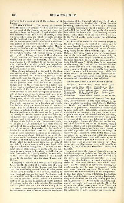
Mr. Blackadder estimates the extreme length of
the county, from east to west, at 31^ miles, and its
extreme breadth, from north to south, at 19i miles;
the mean length at 26^ miles, and the mean "breadth
at 17 miles; and the total contents at 235,440 acres.
But, Mr. Kerr says, "from a very careful considera-
tion of the map itself, attentively measured by its
own scale, the mean length appears to be 28 miles,
the mean breadth 17 miles, and the consequent con-
tents 304,640 acres." Of the three former reporters
on this county, Mr. Low and Mr. Bruce differ from
Mr. Blackadder, and from each other, in the fore-
going enumerated particulars, probably from having
trusted to some old inaccurate maps, while Mr.
Home adopts the measures of Mr. Blackadder im-
plicitly. A comparative enumeration of the several
measures and computations is here subjoined:
COMPARATIVE TABLE OF ESTIMATED EXTENT.
Particulars. Blackad. Low. Bruce. Home. Kerr.
Extreme length, 3li m. 274 m. Omitted 314. m. 84 in.
Extreme breadth, I9| do. lyj do. Omitted 17 do. 21 do.
Mean length, 2fi± do. Omitted 30 m. Omitted 23 do.
Mean breadth, 17 do. Omitted 17 m. Omitted 17 do.
Square miles, Omitted 431. 510. 44A 47fi.
Statute acres, 285,410. 276,000. 326,400. 285,000. 304,fi40.
Since the dismemberment of Berwick from Scot-
land, Lauder remains the only royal borough in the
county ; and, in conjunction with Jedburgh, Hadding-
ton, Dunbar, and North-Berwick, sends one repre-
sentative to parliament. Greenlaw, a small village
37 miles south-east of Edinburgh, in an inconvenient
situation for the purpose, is the county-town, where
all public meetings of the freeholders are convened,
where the sheriff and commissary courts and quar-
ter-sessions of the peace are held, and in which is
the county-jail. Dunse and Coldstream, small towns,
are the only places of any size in the county, though
neither of them are of much importance. But Dunse
is much better fitted — from being more central to
the chief population — than Greenlaw, for being the
county-town. Eyemouth, little better than a fish-
ing village, is the only sea-port within the county.
Small debt sheriff courts are held thrice a-year at
Lauder; six times a-year at Coldstream; at Ayton
thrice a-year; and at Dunse, six times a-year. Jus-
tice of peace small debt courts are held monthly at
Dunse, Ayton, Coldstream, Greenlaw, Lauder, and
Earlston.
In ancient times, the shire of Berwick seems to
have been a separate jurisdiction from the bailliary
of Lauderdale, and to have been itself divided into
the Merse and Lammermoor districts. It is not
easy to say what had been the exact boundaries and
extent of these three divisions, now almost obso-
lete. For the purposes of agricultural inquiry, the
whole county may be very conveniently consid-
ered under two districts, — the Merse and Lam-
mermoor ; the former including all the comparative-
ly low land along Tweed, Whitadder, Blackadder,
and Eye; and the latter comprehending Lauderdale,
along with the more eastern hilly country peculiarly
called Lammermoor. According to the general divi-
sion of the county just pointed out, the Merse de-
signates the whole lower ground from Tweed up
the cultivated slopes of the lower southern range of
the Lammermoor hills, including the western par-
BERWICKSHIRE.
mariners, and is seen at sea at the distance of 15
leagues.
BERWICKSHIRE. The county of Berwick
forms the south-east extremity of Scotland, and lies
on the coast of the German ocean, and along- the
tiorth-east horder of England. Its principal division
was anciently called The Merse, or March, a name
which it still retains, and which probably signifies
the Border-district, or frontier-province.* But this
district seems formerly to have included a consider-
able portion of the eastern lowlands of Teviotdale,
as Roxburgh castle was anciently called March-
mount, or the Castle of the March or Merse. This
denomination, the Merse, is still often used, loosely,
for the whole county. The modern name, Berwick-
shire, is derived from the town of Berwick-upon-
Tweed, once its chief burgh or county-town; but
which, after the demise of Elizabeth, and the acces-
sion of James VI. of Scotland to the English throne,
was constituted a peculiar jurisdiction, hypotheti-
cally separate from both kingdoms, and virtually
forming a distinct county.
Berwickshire is bounded on the east by the Ger-
man ocean; along which, from the boundaries of
Berwick township to St. Abb's Head, its coast trends
north-north-west for 8 J miles. The shore then
takes a west-north-west direction, for other 9 miles,
till its junction with East Lothian at Duuglass
bridge ; and, by the revenue laws, this latter part
of the coast is considered as being within the limits
of the frith of Forth. Almost the whole of this
coast consists of bold rocky precipices of consider-
able altitude; and is nearly inaccessible, except at
Eyemouth and Coldingham bays, and two or three
other places, which are accessible to fishing-boats,
at sandy or gravel beaches at the foot of the rocks.
The whole irregular northern boundary skirts with
East Lothian, along the mountain-range of Lammer-
moor. But, within this line, Berwickshire entirely
surrounds a detached portion of one of the East
Lothian parishes; while the most northerly part of
this county is situated beyond, or to the north of,
the Lammermoor hills, and is continuous with the
extensive and fertile vale of the Lothians. Clint-
hill, one of the highest of the Lammermoor chain,
in the parish of Cbannelkirk, at the north-western
extremity of the county, rises 1,544 feet above the
level of the ocean. Lammerlaw, in the parish of
Lauder, has an altitude of 1,500 feet. The general
range of these mountains declines as it approaches
the sea, averaging about 1,000 feet in perpendicular
elevation, and it terminates in three precipitous pro-
montories, at Fast-castle, Ernscleugh, and St. Abb's
Head ; which last is detached from the extremity of
the chain by a deep narrow dell almost level with
high water mark at spring-tides. The western irre-
gular limit of Berwickshire is partly with Mid-Lo-
thian, towards the north, but chiefly with Roxburgh-
shire, from which it is partly divided, on that side,
by the lower and principal stream of the Leader
water, to its junction with the river Tweed near
Melrose.
Excepting a portion of Roxburghshire adjoining
Kelso, and the township of Berwick, both of which
are on the north side of the Tweed, that beautiful
river, in a meandering course of about 40 miles, forms
the southern boundary of this county, dividing it
from Roxburghshire on the west, Northumberland
in the middle, and North Durham on the east, of
this line of division. North Durham is a detached
portion of the English bishopric and county-palatine
of Durham, having the whole extent of Northumber-
land interposed between it and the main body of the
* Chalmers thinks it more probable it was so called from the
Anglo-Saxon merse, a marsh ; or Iron) mariscus, a naked plain.
patrimony of St. Cuthbert, which once held exten-
sive possessions in Scotland also. From Berwick
township, Berwickshire is divided by a semilunar
dry march, consisting partly of a ruinous dry stone
wall called the Bound dyke, and partly of a narrow-
lane called the Bound road; this boundary extends
from Marshal- Meadows on the sea-shore on the east,
to the Tweed on the west, crossing the Whitadder
in its course.
Mr. Blackadder estimates the extreme length of
the county, from east to west, at 31^ miles, and its
extreme breadth, from north to south, at 19i miles;
the mean length at 26^ miles, and the mean "breadth
at 17 miles; and the total contents at 235,440 acres.
But, Mr. Kerr says, "from a very careful considera-
tion of the map itself, attentively measured by its
own scale, the mean length appears to be 28 miles,
the mean breadth 17 miles, and the consequent con-
tents 304,640 acres." Of the three former reporters
on this county, Mr. Low and Mr. Bruce differ from
Mr. Blackadder, and from each other, in the fore-
going enumerated particulars, probably from having
trusted to some old inaccurate maps, while Mr.
Home adopts the measures of Mr. Blackadder im-
plicitly. A comparative enumeration of the several
measures and computations is here subjoined:
COMPARATIVE TABLE OF ESTIMATED EXTENT.
Particulars. Blackad. Low. Bruce. Home. Kerr.
Extreme length, 3li m. 274 m. Omitted 314. m. 84 in.
Extreme breadth, I9| do. lyj do. Omitted 17 do. 21 do.
Mean length, 2fi± do. Omitted 30 m. Omitted 23 do.
Mean breadth, 17 do. Omitted 17 m. Omitted 17 do.
Square miles, Omitted 431. 510. 44A 47fi.
Statute acres, 285,410. 276,000. 326,400. 285,000. 304,fi40.
Since the dismemberment of Berwick from Scot-
land, Lauder remains the only royal borough in the
county ; and, in conjunction with Jedburgh, Hadding-
ton, Dunbar, and North-Berwick, sends one repre-
sentative to parliament. Greenlaw, a small village
37 miles south-east of Edinburgh, in an inconvenient
situation for the purpose, is the county-town, where
all public meetings of the freeholders are convened,
where the sheriff and commissary courts and quar-
ter-sessions of the peace are held, and in which is
the county-jail. Dunse and Coldstream, small towns,
are the only places of any size in the county, though
neither of them are of much importance. But Dunse
is much better fitted — from being more central to
the chief population — than Greenlaw, for being the
county-town. Eyemouth, little better than a fish-
ing village, is the only sea-port within the county.
Small debt sheriff courts are held thrice a-year at
Lauder; six times a-year at Coldstream; at Ayton
thrice a-year; and at Dunse, six times a-year. Jus-
tice of peace small debt courts are held monthly at
Dunse, Ayton, Coldstream, Greenlaw, Lauder, and
Earlston.
In ancient times, the shire of Berwick seems to
have been a separate jurisdiction from the bailliary
of Lauderdale, and to have been itself divided into
the Merse and Lammermoor districts. It is not
easy to say what had been the exact boundaries and
extent of these three divisions, now almost obso-
lete. For the purposes of agricultural inquiry, the
whole county may be very conveniently consid-
ered under two districts, — the Merse and Lam-
mermoor ; the former including all the comparative-
ly low land along Tweed, Whitadder, Blackadder,
and Eye; and the latter comprehending Lauderdale,
along with the more eastern hilly country peculiarly
called Lammermoor. According to the general divi-
sion of the county just pointed out, the Merse de-
signates the whole lower ground from Tweed up
the cultivated slopes of the lower southern range of
the Lammermoor hills, including the western par-
Set display mode to: Large image | Transcription
Images and transcriptions on this page, including medium image downloads, may be used under the Creative Commons Attribution 4.0 International Licence unless otherwise stated. ![]()
| Gazetteers of Scotland, 1803-1901 > Topographical, statistical, and historical gazetteer of Scotland > Volume 1 > (212) Page 132 |
|---|
| Permanent URL | https://digital.nls.uk/97440090 |
|---|
| Description | Volume first. A-H. |
|---|---|
| Attribution and copyright: |
|
| Description | Glasgow: A. Fullarton & Co., 1842. 2 volumes. Volume 1. A-H.--Volume. 2. I-Z. |
|---|---|
| Shelfmark | Map Room |
| Additional NLS resources: | |
| Description | 20 volumes of the most popular descriptive gazetteers of Scotland, providing a comprehensive geographical encyclopaedia of Scotland in the 19th century. Principal places in Scotland, including towns, counties, castles, glens, antiquities and parishes, are listed alphabetically. Each entry includes detailed historical and geographical information about each place. |
|---|---|