Gazetteer of Scotland > Volume 2
(419) Page 899
Download files
Complete book:
Individual page:
Thumbnail gallery: Grid view | List view

ROXBURGHSHIRE.
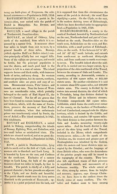
Deing uie birth-place of Fergusson, the cele-
brated astronomer — Population in 1821, 1154.
ROTHIEMURCHUS, a parish in In-
verness-shire, now united with the parish of
Duthil in Morayshire. See Duthil and
ROTHIEMURCHUS-
ROUCAN, a small village in the parish
of Torthorwald, Dumfries-shire.
ROUS AY, an island of Orkney, lying
north of the mainland, from which it is se-
parated by a narrow firth. It measures about
four miles in length from east to west, by a
general breadth of three miles. Rousay,
(which signifies Rolf's or Rollo's island,) con-
sists principally of lofty but not rugged hills.
Some of the valleys are picturesque, and would
be fertile, but the principal population is
near the shores, and much good land in the
interior is left in a state of nature. The island
supports horses and black cattle, with immense
herds of swine, and many sheep. Its western
shores are precipitous, but its eastern, northern,
and southern sides are green and easy of ac-
cess. Monumental stones, Picts' houses, and
tumuli, are not rare. Near the house of West-
ness are considerable ruins, which probably
belonged to the castle of Earl Sigard II., the
hero of Clontarf. Not far off are graves that
have been found to contain human bones, arms,
and trinkets, which, with the name of Swein-
drow, preserve the memory of Earl Paul's
faithful attendants, "when that unfortunate
prince was treacherously seized by Swein, the
son of Aslief. — The island contained, in 1821,
834 inhabitants.
ROUSAY and E GILS HAY, a united
parish in Orkney, comprehending the islands
of Rousay, Egilshay, Weir, and Enhallow,with
two small holms or uninhabited islets. The
whole are situated north of, and at no great dis-
tance from, the mainland. — Population in 1821,
1151.
ROW, a parish in Dumbartonshire, lying
with its south end to the firth of Clyde, and its
western side to Gareloch and Loch Long. It
is bounded by Luss on the east, and Cardross
on the south-east. Exclusive of a narrow
stripe on Loch Long, the bulk of the parish
measures about ten miles in length, by four in
breadth. The parish is chiefly of a hilly and
pastoral character ; the low grounds are adjacent
to the Clyde, and are fertile and beautiful.
The parish church stands near the ferry across
Gareloch to the peninsula of Roseneath ; op-
posite it is a point projected into the loch, and
it is supposed that from this circumstance the
name of the parish is derived ; the word Row
signifying a point. On the Clyde, to the east,
is the modem thriving town of Helensburgh,
which has been described under its appropriate
head.— Population in 1821, 1759.
ROXBURGHSHIRE, a county in the
south of Scotland, bounded by Northumberland
on the east, Northumberland and part of Cum-
berland on the south, Dumfries-shire on the
south-west, Selkirkshire on the west, and Ber-
wickshire, with a small portion of Edinburgh-
shire, on the north. It lies between 55° 6 ' 40",
and 55° 42' 52," north latitude, and extends
from south-west to north-east thirty-eight
miles, and from south-east to north-west twen-
ty-seven. The breadth indeed about the mid-
dle of it, is carried out to a larger extent, by a
projection of the shire northward of the Tweed,
between the streams of Gala and Leader. The
county, according to Arrowsmith, contains a
superficies of 696 square miles, or 445,440
statute acres. By another calculation it is said
to contain about 672 square miles, and 430,000
statute acres. The county is divided by its
waters into several districts, the chief of which
is Tiviotdale, being that division drained by
the river Tiviot and its tributary streams.
Tiviotdale comprehends 521 square miles.
Liddisdale, which forms the south-west corner
of the county, on the borders of Northumber-
land and Cumberland, comprehends the Alpine
territory, which is drained by the Liddle, and
its tributaries, and contains 120 square miles.
The third division is that portion between the
Gala and Leader, measuring twenty-eight
square miles. And the fourth district is that
part of the shire lying north of the Tweed,
included in the Merse, which comprehends
twenty-seven miles. — At the epoch of the
Christian era, the western and greater part of
Roxburghshire was inhabited by the Gadeni,
while the eastern and lesser districts were oc-
cupied by the Ottadini ; and the language of
those British tribes, who were the descendants
of the pristine people may still be traced in
the topography of the country. They have
also left significant traces of their presence
in sepulchral tumuli, and monuments of a
barbarous worship. The whole extent of
the shire, strong by nature, from its heights
and recesses, appears, says George Chalm-
ers, to have been in the earliest times the
bioody scene of many conflicts. The Ot-
tadini and Gadeni seem to have secured
Set display mode to: Large image | Transcription
Images and transcriptions on this page, including medium image downloads, may be used under the Creative Commons Attribution 4.0 International Licence unless otherwise stated. ![]()
| Gazetteers of Scotland, 1803-1901 > Gazetteer of Scotland > Volume 2 > (419) Page 899 |
|---|
| Permanent URL | https://digital.nls.uk/97435850 |
|---|
| Description | Volume II: Glenbanchor to Zetland. |
|---|---|
| Attribution and copyright: |
|
| Description | By Robert Chambers and William Chambers. Glasgow: Blackie & Son, 1838. 2 volumes. |
|---|---|
| Shelfmark | NF.1461.g.7 |
| Additional NLS resources: | |

