Gazetteer of Scotland > Volume 2
(287) Page 771
Download files
Complete book:
Individual page:
Thumbnail gallery: Grid view | List view

METHVEN.
771
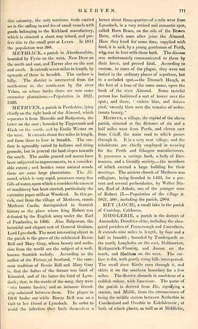
this calamity, the only maritime trade carried
on is the sailing to and fro of small vessels with
goods belonging to the Kirkland manufactory,
which is situated a short way inland, and pre-
fers this to the small port at Leven. In 1811
the population was 388.
METHLICK, a parish in Aberdeenshire,
bounded by Fyvie on the west, New Deer on
the north and east, and Tarves also on the east
and south. It extends seven miles in length, by
upwards of three in breadth. The surface is
hilly. The district is intersected from the
north-west to the south-east by the river
Ythan, on whose banks there are now some
extensive plantations. — Population in 1821,
1320.
METHVEN, a parish in Perthshire, lying
chiefly on the right bank of the Almond, which
separates it from Monedie and Redgorton, the
latter on the east ; bounded by Tippermuir and
Gask on the south, and by Foulis Wester on
the west. It extends about five miles in length,
and from three to four in breadth. The sur-
face is agreeably varied by hollows and rising
grounds, but in general the land slopes towards
the south. The arable ground and moors have
been subjected to improvements, to a consider-
able extent ; and besides some natural woods
there are some large plantations. The Al-
mond, which is very rapid, possesses many fine
falls of water, upon which a considerable amount
of machinery has been erected, particularly the
extensive paper mills at Woodend. In this pa-
rish, east from the village of Methven, stands
Methven Castle, distinguished in Scottish
history as the place where king Robert was
defeated by the English army under the Earl
of Pembroke, in 1306. Also Balgowan, the
beautiful and elegant seat of General Graham,
Lord Lynedoch. The most interesting object in
the parish is the grave of the celebrated Bessie
Bell and Mary Gray, whose beauty and seclu-
sion from the world are the subject of a well-
known Scottish melody. According to the
author of the Picture >f Scotland, " the com-
mon tradition of Bessie Bell and Mary Gray
is, that the father of the former was laird of
Kinnaird, and of the latter the laird of Lyne-
doch ; that, in the words of the song, they were
' twa bonnie lassies,' and an intimate friend-
ship subsisted between them. The plague in
16ti6 broke out while Bessie Bell was on a
visit to her friend at Lynedoch. In order to
avoid the infection they built themselves a
bower about three-quarters of a mile west from
Lynedoch, in a very retired and romantic spot,
called Burn Braes, on the side of the Brawn
Burn, which soon after joins the Almond.
Here they lived for some time, supplied with
food, it is said, by a young gentleman of Perth,
wh$.was in love with them both. The disease
was unfortunately communicated to them by
their lover, and proved fatal. According to
custom, in cases of the plague, they were not
buried in the ordinary places of sepulture, but
in a secluded spot,— the Dronach Haugh, at
the foot of a brae of the same name, upon the
bank of the river Almond. Some tasteful
person has fashioned a sort of bower over the
spot; and there, ' violets blue, and daisies
pied,' sweetly blow over the^ remains of unfor-
tunate beauty."
Methven, a village, the capital of the above
parish, situated at the distance of six and a
half miles west from Perth, and eleven east
from CriefF, the main road to which passes
through it. It is a very neat village, and the
inhabitants are chiefly employed in weaving
for the Perth and Glasgow manufacturers.
It possesses a savings bank, a body of free-
masons, and a friendly society, — the members
of which erected a large building for their
meetings. The ancient church of Methven was
collegiate, being founded in 1433, for a pro-
vost and several prebendaries, by Walter Stu-
art, Earl of Athole, one of the younger sons
of Robert II. — Population of the village ir;
1821, 500; including the parish, 2904.
MEY (LOCH), a small lake in the parish
of Canisbay, Caithness.
MIDDLEBIE, a parish in the district of
Annandale, Dumfries-shire, including the abro-
gated parishes of Pennersaugh and Carruthers.
It extends nine miles in length, by four and a
half in breadth ; bounded by Tundergarth on
the north, Langholm on the east, Halfmorton,
Kirkpatrick- Fleming, and Annan on the
south, and Hoddana on the west. The sur-
face is flat, with gently rising hills interspersed.
The small river Kirtle runs through it, and
skirts it on the southern boundary for a few
miles. The district abounds in sandstone of a
reddish colour, with limestone. The name of
the parish is derived from Bie, signifying a
station, and Middle, from the circumstance of
being the middle station between Netherbie in
Cumberland and Overbie in Eskdalemuir ; at
both of which places, as well as at Middlebie,
Set display mode to: Large image | Transcription
Images and transcriptions on this page, including medium image downloads, may be used under the Creative Commons Attribution 4.0 International Licence unless otherwise stated. ![]()
| Gazetteers of Scotland, 1803-1901 > Gazetteer of Scotland > Volume 2 > (287) Page 771 |
|---|
| Permanent URL | https://digital.nls.uk/97434266 |
|---|
| Description | Volume II: Glenbanchor to Zetland. |
|---|---|
| Attribution and copyright: |
|
| Description | By Robert Chambers and William Chambers. Glasgow: Blackie & Son, 1838. 2 volumes. |
|---|---|
| Shelfmark | NF.1461.g.7 |
| Additional NLS resources: | |

